
Photo by TJ aka Teej
Mount Katahdin marks the northern extreme of the Appalachian Trail and is established in the American consciousness through its place in US literature.
Name: Mount Katahdin or Katahdin.
Height: 1,606 m (5,269 ft)
Location: In Baxter State Park, Maine, USA
First Climbed: 13 August 1804 by Charles Turner, Jr. and Zackery Adley.
Climb Time: 8-10 hours
Best Time to Climb: June-September
INTRODUCTION TO MOUNT KATAHDIN
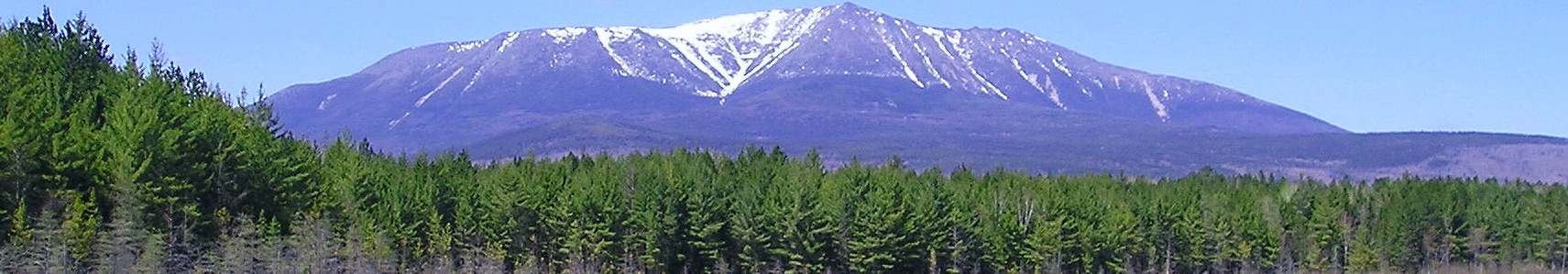
Maine’s highest peak and the focal point of Baxter State Park, Mount Katahdin (1,606 m/ 5,269 ft) lives up to its name, at least locally.
The Greatest Mountain is more commonly known as simply, Katahdin. Home to a thrilling ridgeline challenge in the Knife Edge, and more hikes than you could possibly complete in one visit. Katahdin makes sure no-one is left out, providing hiking challenges across a range of levels.
Jump to Climbing or Hiking Guide
This mountain marks the northern extreme of that great American hike, the Appalachian Trail (AT). It is also embedded in the American consciousness through the writings of Henry David Thoreau during the 19th Century and numerous other artistic responses to its towering form that makes it appear larger than its measurements suggest.
National Geographic described Katahdin as, potentially: “the most inspiring peak in all of eastern North America”, and who would want to argue with that?
HISTORY OF MOUNT KATAHDIN
First encountered by Europeans in 1689, Katahdin’s history with the indigenous Native American population stretches back much further. But it is not all positive: Abenaki tribes believed the mountain is home to the bird spirit Pamola.
Pamola is the storm god/god of thunder and protector of the mountain. He had the head of a moose, the body of a man and the wings and feet of an eagle. As such, many avoided the area for fear of provoking cold weather, or encountering such an ill-proportioned creature!
Yet even for the more recent arrivals to the area, the connection to this mountain has clearly been woven deeply. A former governor of Maine, after whom the state park is named, Percival B Baxter commented: “Katahdin in all its glory, forever shall remain the Mountain of the People of Maine”.
The name Katahdin comes from Penobscot, the language of Maine Native Americans. As mentioned above, it means ‘The Greatest Mountain’.
Early writings referred to similar names, suggesting this has been the name used as far as anyone could remember. But for some time these differed in spelling: Ktaddn was proposed by Thoreau; Catardin was the name used by the first to climb it in 1804; while Teddon was the name used by the first European to see it, John Gyles in 1689.
It was officially named (and spelled, presumably) Mount Katahdin in 1893.

Two US Navy ships have been named after the mountain (perhaps best not to ask what happened to the first), as has a potato, certified in 1932 and still popular today!
Katahdin’s role as a muse of the artistic world is also well established. It has inspired paintings, such as Frederic Edwin Church’s from 1860 that recently sold for $3.1 million. It even has a short piano sonata written for it.
Thoreau, a writer indelibly linked to the American wilderness in general and this mountain in particular, explored the area in detail during 1846. He climbed the peak in order to “come face-to-face with the raw soul of nature”. There, he wrote:
“The tops of mountain are among the unfinished parts of the globe,
whither it is a slight insult to the gods to climb and pry into their secrets,
and try their effect on humanity.
Only daring and insolent men, perchance, go there…
Pamola is always angry with those who climb to the summit of Ktaddn”.
GEOGRAPHY OF MOUNT KATAHDIN.
Katahdin is located in Maine, a north-eastern US State. The summit is 96.5 km (60 miles) south-east of the Canadian border near Quebec. It has a significant prominence (1,307 m/ 4,288 ft), standing as a tall, exposed massif above the landscape.
Katahdin has five summits, none of which are named Mount Katahdin. The highest of these, which stands above the rest of the US State of Maine at 1,606 m (5,269 ft), is Baxter Peak.
Kathdin’s summit area is on a horseshoe-shaped ridgeline, linking the various satellite peaks.
It curves from Pamola Peak (1,494 m/ 4,902 ft) in the south-east, heads west to Chimney Peak (1,441 m/ 4,728 ft) and Baxter Peak then heads north to Hamlin Peak (1,450 m/ 4,756 ft). Here the ridgeline splits, one descending to the east, the other continuing north to the two Howe Peaks (1,443 m/ 4,734 ft and 1,406 m/ 4,612 ft).
To the west of Baxter Peak is another ridgeline, by which the summit is often gained (see below). To the south of this is Thoreau Spring, another wilderness landmark named after the writer.
The mountain itself was formed as a granite intrusion. In this type of orogeny, lava is pushed up between two layers of sedimentary rock, forcing them apart and one upwards. As the softer rock is worn away, the tough granite is exposed.
The horseshoe and steep-sided formation was carved out by monumental glacial activity in the distant past. It has left almost sheer mountain faces and one of the most famous, and daunting, ridgeline adventures in the world (see below).
At the centre of the horseshoe is the Great Basin, containing evidence of the glacial past (such as moraines and cirques) and Chimney Pond, the site of an often-used campground. Ponds like this are typical in the area, where numerous small rivers flow away from the mountain into the green landscape of Baxter State Park.
Baxter State Park preserves a large area of wilderness, containing numerous mountains, valleys and lush green landscape. It was formed from 1931 onwards through donations of land by governor Baxter, who bought land and gifted it to the state in order to protect it from logging.
What extends south from Katahdin, through and beyond the State Park, is the Hundred Mile Wilderness. This notorious section of the AT heads through uninhabited land with no places to resupply. You can read about just how wild this section of hiking is here.
Pamola Peak preserves the name of the eponymous Abenaki god who is said to reside on the mountain, though is better known these days for being one end of the tight wire that is the Knife Edge.
WILDLIFE OF MOUNT KATAHDIN
Flora.
The environment around Mount Katahdin is extremely vulnerable to human influence, particularly above the treeline during the shoulder seasons of spring and autumn. Yet the park rangers clearly trust nature to lead the way, stating (in relation to closing the AT): “nature determines when the Trail closes, not us”.
The flora around Mount Katahdin is typical of New England.
Up to 914 m (3,000 ft), a mixed coniferous forest containing beech, maple, spruce, fir and hemlock creates a thick covering. It is from this dense green that Katahdin rises, like an island in the sky.
From 914 m (3,000 ft) to the tree line at 1,280 m (4,200 ft), these trees become stunted by the increasingly difficult conditions for growth. Many poke out from cracks between boulders and grow to relatively unimpressive forms. Yet, with so little competition for places, some trees should be revered for having survived there for a very long time.
Above the tree line, alpine conditions are found in an area known as the Tableland Tundra. This name reflects the flora and conditions that are comparable to the Arctic Tundra, although this starts several hundred miles north of here.
Some of the delicate flowers found in this area include mountain sandworts, bigelow’s sedge, black crowberry, three-forked rush and bilberry. These, or relatives of them, are only found at these heights or in the tundra far to the north.
The summit area, defined as above 1,524 m (5,000 ft), only contains lichen and bare rock.
Fauna.
Typical of New England wilderness, the fauna found near Katahdin reads like a who’s who of this region. Black bears, deer and moose are the largest of the regulars, but it is the smaller inhabitants in which we find some uniqueness for Katahdin.
Black flies are, incredibly, a popular sight on the mountain (though this refers to their numbers rather than their appeal). More enticing is the mountain’s own indigenous butterfly.
The Katahdin Arctic butterfly is endemic to the mountain. With dark grey/brown wings with orange patches, and a wingspan of 33-51 mm, you’ll do well to spot one of these fluttering by. Moreso given their current endangered status.
FIRST ASCENT OF MOUNT KATAHDIN
Two surveyors from Massachusetts, Charles Turner, Jr. and Zackery Adley, were the first to record a summit of Katahdin, on 13 August 1804.
They completed the summit ascent within a day. Turner wrote: “at 8 o’clock we left our canoes at the head of the boat waters….at 5 o’clock we reached the summit of the mountain.”
Turner was coming to end of a successful career in the military and had recently been elected into the House of Representatives. He went on to serve in the Senate, yet his first ascent of Katahdin ranks with these achievements in his biography.
CLIMBING GUIDE FOR MOUNT KATAHDIN
The best time to climb Katahdin is between June and September, as snow can be found from the tree line and higher between October and May.
The most popular route up Katahdin is the Hunt trail. Gaining 1,277 m (4,188 ft) in 8.5 km (5.2 miles, one-way), the route begins at a trailhead to the south of the peak in Katahdin Stream Campground.
It is a route used by the Appalachian Trail, and must be a pretty daunting finish to such an epic adventure. For those who have not trekked across most of America, it is simply a thrilling, long day-hike.
The first 1.75 km (1.1 miles) is leisurely walking, passing streams and waterfalls. Passing the junction with the Owl Trail, you cross a bridge and approach Katahdin Stream Falls—one highlight of this adventure.
Reaching the treeline, the terrain changes to large boulders. Traversed using metal bars, chains and ladders, this is the most difficult part of the climb, though more of a physical challenge than a technical one.
Cresting the Hunt Spur, there is one more small ascent to reach Tableland, the tundra-like plateau that leads to the summit. This last climb can be exposed but is not nearly as narrow as the Knife Edge (see below).
Tableland passes above Thoreau Spring around 2 km (1.4 miles) from the summit and this is where the Abol Trail joins. Easy walking from here to the summit finishes an ascent in around 5-6 hours.
Allow 8-10 hours for the return (last departures are regulated by the park for safety).
Another trail from the south of the mountain is the Abol Trail. At 7 km (4.3 miles, one-way) it is shorter than the Hunt Trail and faster as a result. It also doesn’t have the same amount of traffic as it is not used for the Appalachian Trail.
The trail departs from the Abol Campground, ascending the south face of Katahdin. It is described as “monotonously steep”, joining the more moderate Hunt Trail 1.5 km (1 mile) from the summit.
The original route has been partly replaced by newer switchbacks, extending the length but reducing the risk. This process closed the trail from 2014-2016, but it is now open again.
As much of the route is comparable to climbing up a steep stony beach, the risk of sliding down further than you climb up is always present. So this is a route for those wishing to channel patience too!
But the most famous route has to be the one that traverses the Knife Edge. This ridge, stretching between Pamola and Baxter Peaks, has claimed 23 lives since 1963 so should certainly not be taken lightly.
This trail needs to be reached by one of the other trails, beginning as it does on one of the two peaks. It is 1.75 km (1.1 miles) in length. For around 600 m (1,969 ft) of this it is only 2 ft (0.6 m) wide, and with sheer drops either side, it has the potential to be fatally unforgiving.
Other trails on the mountain include:
• Helen Taylor: A 5 km (3.2 mile) route to Pamola Peak, ascending from the east of the mountain.
• Saddle Trail: An ascent from the ‘front’ (inside the horseshoe) of the mountain to Baxter Peak. An easier option, without any large boulders. 3.5 km (2.2 miles)
• Cathedral Trail: A short, steep trail up the front of the mountain, this 2.75 km (1.7 mile) hike passes three giant granite towers, known as Cathedrals 1, 2 and 3.
• Hamlin Ridge: a shorter trail to the Hamlin Peak in the north of the massif.
• Dudley Trail: A 2 km (1.3 mile) approach to Pamola Peak from the north of the mountain, known for its boulders that must be climbed through rather than over. This route includes Index Rock: a jutting formation around 100 m (330 ft) long, seen in many spectacular photos taken by hikers.
INFORMATION ON TREKKING AROUND MOUNT KATAHDIN
There is one very important point to consider when planning a hike up or near Mount Katahdin. The number of hikers permitted in Baxter State Park are regulated by controlling the number of cars that can enter the park each day. Best to register online for entry and arrive early on the day.
As the northern terminus of the 3,541 km (2,200-mile) Appalachian Trail, the first place to head from Mount Katahdin would be south. You’ll be in the minority though; most thru-hikers begin in the south and use Katahdin as their finish line.
The first legs of the Appalachian Trail south from Katahdin are tough, heading through the notorious Hundred Mile Wilderness. But if you navigate this then the expanse of route that lies ahead of you means your adventure could run for (almost) as long as you would wish to go for!
Closer by is the surrounding wilderness of Baxter State Park. This area is open year-round, though be aware of the restrictions on camping and car entry.
As the Baxter State Park website tells us, the 322 km (200 miles) of hiking trails are the “heart and soul” of the place.
The pinnacle of these day hikes are the ascents of Katahdin, but offer a variety of challenges through the landscape of forests, rivers, lakes and waterfalls, as well as those mountains! These include Big and Little Niagara Falls (no, not the Niagara Falls but they are still pretty nice!)
Just underneath the summits of Katahdin is a short trail around Chimney Pond. It is used to access the mountain from the ‘front side’ but is also an enjoyable trail passing many lakes, ponds, streams and waterfalls. At 5.5 km (3.3 miles) and pretty flat going, this is one of the easier adventure options near the mountain and can lead you back to a night spent in the shadow of the greatest mountain.