
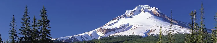
On the opposite side of the Columbia river from Mount Rainier (4,392 m/14,411 ft) lies a mountain with an explosive history and an uncertain height. Mount Hood, a volcano last active a hundred years ago, is a popular destination for skiers and hikers alike.
Name: Mount Hood.
Other name: Wy’east (Native American).
Height: 3,429 m (11,249 ft)
Location: In the Cascade Volcanic Arc in northern Oregon, USA.
First Climbed: 11 July 1857 by Henry Pittock (disputed)
Climb Time: Most of a day.
Best Time to Climb: May to July.
INTRODUCTION TO MOUNT HOOD.
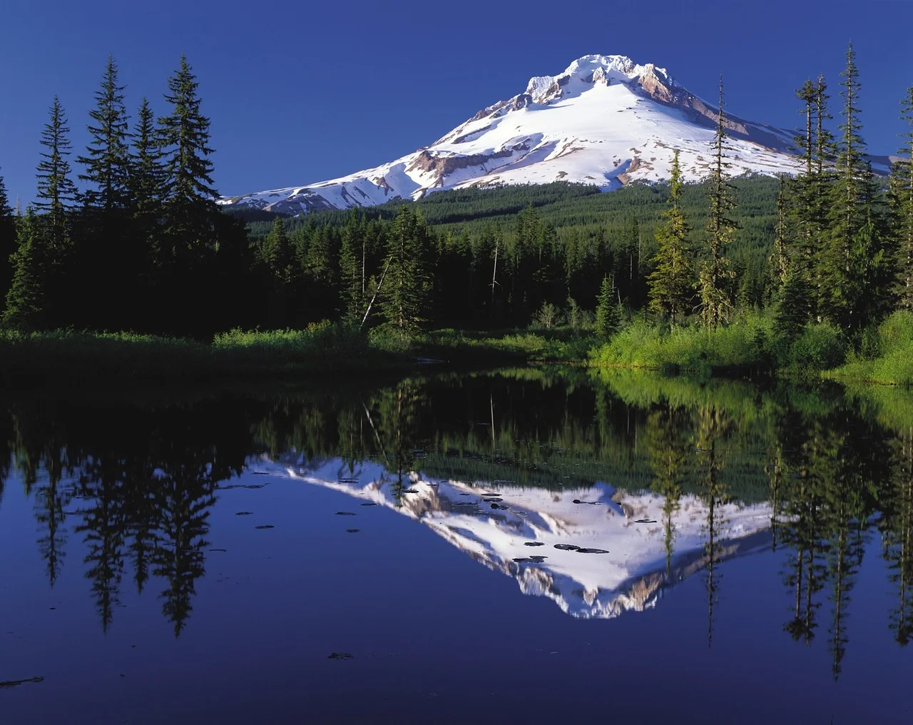
Located in the lush Mount Hood National Forest, and surrounded by an enviable array of wildlife, the tallest mountain in Oregon offers ice, snow and rock adventures to climbers and hikers. With 12 glaciers lining its white slopes, Mount Hood is one of the first of the alpine challenges available, as you travel up the west coast of the US towards Canada and Alaska.
Posing the potential for genuine challenge, while also having gently curving slopes, typical of its formation, Mount Hood can offer a desirable mountain adventure to almost anyone.
Jump to Hiking & Adventure Guide
HISTORY OF MOUNT HOOD.
Mount Hood was named on 29 October 1792 by Lieutenant William Broughton, part of Captain George Vancouver’s discovery expedition. The mountain was named after Samuel Hood, a British Admiral influential in the American Revolutionary war among other campaigns.
However, the name given to it by the local indigenous people is Wy’east. In Native American mythology, this mountain is strongly linked to nearby peaks Pahto (Mount Adams), Si Yett/Lavelatla/Loowitlatka (Mount St Helens) and Klickitat (Mount Rainier).
Myths, from various tribes including the Multnomah, Yakima, Klickikat and Puyallup tribes share variations of a similar myth.
They are centred on an ancient bridge, formed by enormous landslides that poured into the Columbia river. In the centre of this bridge, so the myths go, was the only fire in the world, protected by the old woman Loowitlatkla, meaning the ‘Lady of Fire’.
She was so kind to the Native Americans who came to light their own fires from hers that one chief gave her the gift of eternal life and his two sons, Wy’east and Klickitat. But she wished to young and beautiful too, so he granted this also.
But when his sons arrived from the south and north respectively, they fought for her love and her beauty. Such was their mutual destruction of the surrounding landscape, the chief, Sahale, destroyed the bridge and killed all three of them. Where each of them fell, he grew a great mountain.
Mount Hood.
There have been some calls recently for this mountain to adopt its original name, like Denali in Alaska. However, no definite moves to this effect appear in motion.
Mount Hood’s uncertain elevation…
Reading the history of the elevation of Mount Hood would make you believe its summit is a moveable yo-yo.
The measurement we have used is the official height endorsed by the US National Geodetic Survey at 3,429 m (11,249 ft), set in 1991 from a measurement made in 1986. However, there are two other commonly quoted heights, 11,240 ft and 11,239 ft (both 3,426 m).
However, back in the mid-19th Century, estimates varied far wider, between 3,421 m (11,253 ft) in 1867 and 5,900 m (19,400 ft) in 1854!
This upper estimation was made by an ambitious Mr Belden, who claimed that ‘pores oozed blood, eyes bled and blood rushed from ears’ near the summit. It is not clear whether he was in ill health on his ascent, overly sensitive to altitude or simply a fan of drama and publicity.
Yet because of these accounts, there have been periods where it has been believed that Mount Hood was the highest point in all North America. Now it is ranked outside the top 200.
Caution on the slopes.
While there have been a huge number of successful ascents, Mount Hood has also seen over 130 deaths since records began in 1896. Most are due to hypothermia or falls, with incidents in 1986, 2006 and 2009 receiving significant public interest.
The worst incident was in May 1986, when seven students and two teachers froze to death during an annual Oregon Episcopal School climb.
GEOGRAPHY OF MOUNT HOOD.
Mount Hood is the tallest mountain in Oregon, 230 m (755 ft) taller than Mount Jefferson. However, it is nearly a kilometre lower than Mount Rainier in Washington State and doesn’t feature in the top 200 North American mountains.
Mount Hood is a stratovolcano, with some debate surrounding whether it is still active. The last period of eruptions, from high up on the south-west flank, is estimated to have occurred between 220-170 years ago. This consisted of numerous pyroclastic flows (lava), but there is no evidence that they were particularly explosive eruptions.
In total, in the past 1,800 years, it is believed the volcano has erupted during three short periods, with one further period of eruption in the 13,000 preceding years. The last minor activity was observed in 1907.
So, it appears there’s no need to move the nearby populations away from the mountain too soon, or indeed delay your adventure to the mountain!
Mount Hood’s gently curved sides invite over 10,000 summit attempts per year, making it one of the most climbed mountains in the world. It is located in Mount Hood National Forest, 4,318 km2 (1,667 sq miles) of wilderness area east of Portland.
Some 36 km (22.5 miles) to the north is the Columbia river. At 2,000 km (1,243 miles) long, it is the largest river in the Pacific North-west. During previous eruptions and collapses of sections of the mountain, avalanches and lahars (fast-moving mudflows) have reached this river.
Glaciers.
Mount Hood hosts glaciers along all its flanks, with the highest concentration to the south and west. The largest of the 12 discrete glaciers is the Eliot glacier, covering an area (in 2004) of 395 acres with a thickness of up to 110 m (361 ft). Yet since 1901, it is estimated to have retreated by 680 m (2,230 ft);10 of the other 11 glaciers on Mount Hood have retreated even more than this.
These glaciers have done much to shape the mountain, disrupting the shape of the summit cone and leaving moraines all along the south-east flanks. Some of these deposits date back over 140,000 years.
The majority of the glaciers today are found above 1,800 m (6,000 ft), which is also the level of the tree line. In fact, more than 80% of glacial surface area is found above 2,100 m (7,000 ft). The most visited ice river is the Palmer glacier, on the south south-west slopes. This hosts of a number of trails and a ski area.
The last melt waters from the previous Ice Age (around 10,000 years ago) did much to smooth and flatten the surrounding Upper Hood river valley. These glaciers, at their largest, stretched over 15 km (9.3 miles) from the summit.
WILDLIFE OF MOUNT HOOD.
Flora.
Many trees are found around Mount Hood, whose tree line stretches up to 1,800 m (6,000 ft). The range of species of trees is quite amazing with Mount Hood representing much of the tree diversity of the whole north-west of the US.
At the lower reaches, Engelmann spruce, northern oak, American elm and red maple are found. This last tree is more associated with Canada, with its distinctive leaves that turn a vibrant red each autumn (fall).
Further up the slopes, in the Canadian zone, from 600-1,500 m (2,000-5,000 ft), western larch, lyall’s larch, and lodgepole and tamarack pine, are all found.
At the tree line varieties of hemlock, and alpine and silver firs are found. Above this point, the near 80% coverage of glaciers makes plant life all but impossible.
Fauna.
There are numerous amphibians and reptiles found on Mount Hood. These include the garter and milk snakes, the hard-to-see spotted salamander and the less-than-desirable American toad.
There are also large snapping turtles found near freshwater lakes. Don’t get too close to them though; they are renowned to be combative when out of water.
Animals you’re more likely to spot include foxes, red squirrels, raccoons and chipmunks, along with turkeys, bats and 150 other bird species.
A harder spot would be the eastern coyotes, though if you see one you’ll see likely see another as they hunt in pairs. They are hybrids of wolves and coyotes, with a genome that also contains domestic dog DNA.
Finally, the oddly named fisher cat is not a cat at all, but rather a type of marten. It is a small carnivorous animal found in woodland and is native to North America.
FIRST ASCENT OF MOUNT HOOD.
The accepted first ascent occurred on 11 July 1857 by Henry Pittock and three others. He provided a well-documented account, allowing Pittock to claim that his clear knowledge of the whole ascent was proof enough of the accolade.
The disputed first ascent of Mount Hood occurred on 8 August 1854 by Thomas Dryer.
His account reflects discoveries of fumaroles (volcanic vents) on the volcano, revealing activity in the mountain that was previously not known. But his account of the ascent is not as detailed as the Pittock ascent, perhaps missing details of the mountain’s higher reaches.
The account of a Dryer team member, Liddell, notes how many of the team dropped out en route, so it is possible that this created some doubt too. If so, it is thought they only reached a point a few hundred feet short of the summit, and this is the reasoning that remains today.
CLIMBING GUIDE TO MOUNT HOOD.
Climbing is recommended May-July, between the avalanche season (winter) and the opening up of crevasses (mid-summer). While climbing is available year-round, the chances of avalanches or falls increase significantly outside of these few months.
There are a number of climbing routes found around the whole mountain, as well as several sites for sport climbing, ranging up to Hard Very Severe climbs (US Grade 5.9+).
Hogback route.
The most popular route is the Hogsback route on the south side of the mountain. This is a day-long walk with some sections of snow climbing up 45º, but is estimated to be no more than class II difficulty.
The route begins at a National Historical Landmark, Timberline Lodge (1,817 m/ 5,960 ft), built in 1938.
The trail starts with 3 km (2 miles) of hiking up the east (right) of the ski trails to the top of the ski lift (2,621 m/ 8,600 ft). Heading toward Crater Rock along the ridge, you enter and pass through this landmark, again staying to the eastern side.
Taking the snow ridge, known as Hogsback (3,231 m/ 10,600 ft), hike up to the bergschrund, crossing the crevasse via a snow bridge, or walking around it. The summit ascent is best navigated through the Pearly Gates, rock towers that line a gully, leading to the summit ridge, followed by the summit.
Descent usually follows the same route, this time to the left of Crater Rock. However, in bad weather, be sure not to follow the distinctive fall line, a line that defines the border between upland and lowland.
On the other side of this will be potentials for fatal falls into the Zig Zag canyons below.
Cooper Spur route.
Another route is the Cooper Spur route, a class II hike to the north-east of the mountain.
The Cooper Spur is a huge moraine to the south-east of the Eliot glacier, which finishes around 2,590 m (8,500 ft), at a point known as Tie in Rock.
The route, marked Timberline trail 600, follows along a ridgeline from here to the south of the Eliot glacier, and the summit is in view for most of the climb.
Permanent snow and ice covers the route above 2,743 m (9,000 ft), with steadily increasing steepness up the slopes. These reach 50º near the summit. In the summer, the upper reaches above 3,200 m (10,500 ft) are also snow free, as they are exposed to the sun, revealing the loose rock and gravel surface underneath.
This is also the area with the largest range of rock and ice climbing, including on the Eliot, Coe and Newton Clark glaciers. The routes have ominous names including the Black Widow, Arachnophobia and The Devil’s Ramp.
Sandy Glacier Headwall route.
For a more challenging and, by all accounts, enthralling adventure, try the Sandy Glacier Headwall route. This route requires several days, with bivouacs on the mountain. It is known as an alpine route, meaning there’s a combination of climbing and hiking over both rock and ice.
The approach crosses from the Timberline Lodge to the south across the west of the mountain to reach Sandy glacier on the north side. The climb then proceeds up the centre of the glacier until an open bowl is met. Head east through a gully from here to reach Cathedral Ridge from where you can gain the summit.
Descent normally uses the Hogsback route. It is advised to follow this route up in preparation too before attempting this alpine climb, as the descent can occur late in the day and, in bad weather conditions, a lack of knowledge may force an extra, unnecessary night on the mountain.
INFORMATION ON ADVENTURES AROUND MOUNT HOOD.
Skiing and Snowboarding.
Mount Hood is a popular ski and snowboard destination. While Mount Hood village is located due east of the mountain, the main destination for adventurers is Government camp, further south-east along the Route 26.
With 430 inches of annual snowfall (almost 2 m) and 85 ski runs up to 5 km (3 miles) in length, it offers good ski options at the southern edge of one of the finest ski regions in the world. 400 km (250 miles) north is the Canadian border, near Vancouver.
Day-hikes.
There are also numerous short day-hike trails, around the area surrounding Mount Hood. As is typical of the highly structured approach to the wilderness in the US National Parks and Forests, these trails are conveniently divided into summer trails and winter trails, all beginning from Government Camp/Mount Hood’s Alpine Village, 10 km (6 miles) south-west of the summit.
The longest summer trail is the one-way Pioneer Bridle trail. The trail drops 634 m (2,080 ft) over the course 13 km (8.2 miles).
This hike takes you from Government Camp to the town of Rhododendron to the west. The trail follows the Barlow road, which is part of the historical Oregon trail. Pioneers and their wagon trains would use this trail to arrive in Oregon without rafting the wagons down the Columbia river.
The winter trails are designed for cross-country skiing and snowshoe walking, as with the significant snowfall they become too difficult to hike.
Other trails, including numerous waterfall and lake circuits, can be found here. All the trails are numbered and named, with signage en route to keep you easily on track. They are designed for a recreational adventure rather than particularly strenuous challenges!