
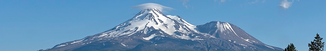
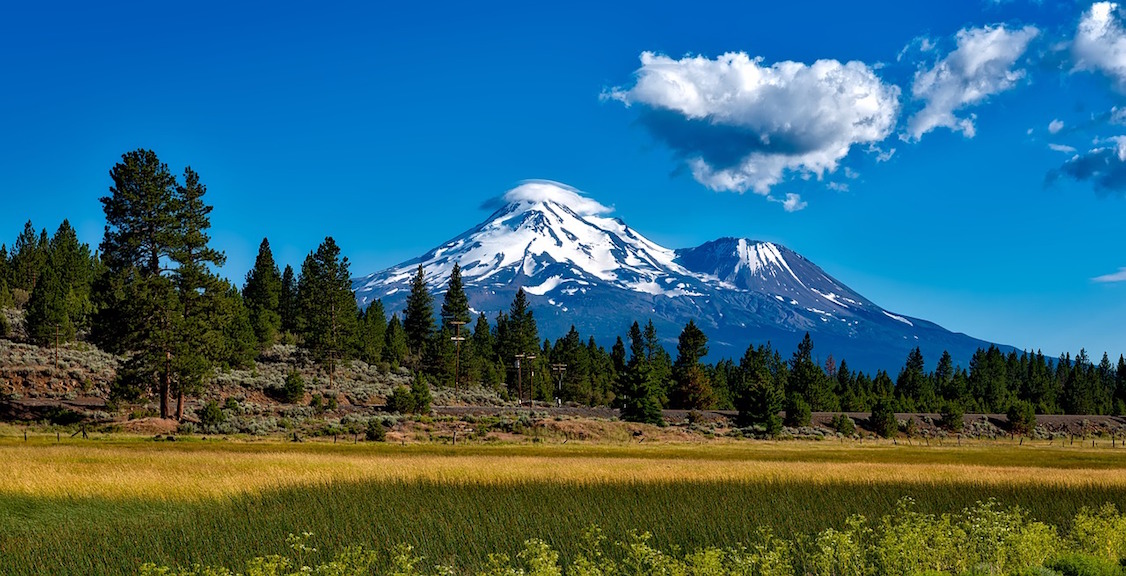
A National Natural Landmark, an explosive threat to those living nearby and a great invitation for summer or winter hiking: Mount Shasta (4,322m/ 14,179 ft) offers plenty of drama for real or imagined adventures alike.
Name: Mount Shasta
Height: 4,322 m (14,179 ft)
Location: Part of the Cascade Range in Siskiyou County, northern California, USA.
First Climbed: 14 August 1854 by Captain Pearce and four other climbers.
Climb Time: 1-2 days
Best Time to Climb: May to October
Introduction to Mt. Shasta.
Mount Shasta is the fifth highest in California and the second highest peak in the Cascade Range. It’s also a volcano, with increasingly regular eruptions occurring every 600 years, (don’t worry, the next isn’t due until the year 2386!).
Offering a range of routes, from the non-technical to the very technical, Mount Shasta can likely offer exactly the challenge you’re searching for. With year-round snow at its peak, this is also one adventure you’ll need your crampons and ice axe for.
With views over northern California, the Cascade Mountains to the north and the Sierra Nevada to the south, Mount Shasta promises and delivers a powerful and exciting adventure punch.
History of Mount Shasta.
Archaeological records show humans have lived near Mount Shasta throughout the last 5,000 years, and possibly as far back as 7,000 years ago. When European explorers came to the area, nine different Native American tribes lived here, including the Shasta tribe.
Another local Native American tribe, the Karuk, knew the the mountain as Útaahkoo, meaning ‘White Mountain’. View any pictures of the mountain and you’ll quickly work out why.
Mount Shasta is the site of a fascinating myth.
Skell, the Spirit of the Above-World, is said to have descended to this mountain top in order to fight Liao, the Spirit of the Below-World. In this battle of above and below (and good and evil perhaps), it is said they threw hot rocks and lava, no doubt referencing the volcano’s violent eruptions.
Shasta minute! Its beautiful.
Mount Shasta continues to be a centre of attention of New Age movements worldwide. A Buddhist monastery was established on Mount Shasta in 1971.
The history of the modern name ‘Shasta’ is disputed. Some reports state that it comes from the Russian Tchastal meaning ‘Pure White Mountain’. Others claim it is directly named after the local tribe the Shasta, though others contest this point, claiming instead that it was the tribe who was named after the mountain.
The early usage of Shasta was also confused. The first westernised usage was in the reports of by a Hudson’s Bay Company fur trapper, Peter Skene Ogden, in 1827. He referred to a mountain, tribe and river variously as Sasty, Sistise, Castice and Sastice. However, it’s believed he was actually referring to to the nearby Mount McLoughlin (2,895m/ 9,499 ft).
But the Wilkes expedition of 1842 referred to modern-day Mount Shasta by Ogden’s names (and some four other variants), and so named it as such. So for a while Mount Shasta had an identity crisis!
- Read about other important US & North American mountains in our Mountain Info Page
- Read our Introduction to the Colorado 14ers
In 1850, the modern name Mount Shasta finally stuck, with the ‘a’ at the end thought to be chosen to reflect the similar Spanish names of other local geographical features.
A traditional Native American trade and travel route passes the foot of Mount Shasta. This is part of a sprawling network of former river valley routes navigating between San Francisco in central California and Portland in the Pacific Northwest.
This route became known by early european settlers as the Siskiyou Trail, named after the Siskiyou Mountains of southern Oregon through which it passes. This route was adopted by early fur trappers and traders and allowed them move efficiently along the west coast. Nowadays, it is mainly covered by the somewhat less idyllic Interstate 5.
Geography of Mount Shasta.
Mount Shasta is located in its own 155 km2 (60 sq mile) wilderness area within the Shasta-Trinity National Forest, just south of the Oregon border. Its significant prominence, more than two-thirds of its full height (2,994 m/ 9,822 ft, 96th largest in the world), allows it to be seen on a clear day from the Central Valley, some 230 km (143 miles) to the south.
Mount Shasta is an active stratovolcano. It lies at the southern end of the 1,300 km (808 mile) Cascade Range, which extends from southern British Colombia down to northern California. The range includes 20 significant volcanos, including Mount Shasta, Mount Rainier (4,394 m/ 14,417 ft) and Mount St Helens (which, after 1980 eruption, was reduced to 2,549 m/ 8,363 ft), and is known as the Cascade Arc.
The formation of Mount Shasta is etched into its slopes. Viewed from above, the mountain looks as if it were still molten, covered with deep crevices and lines of material from former pyroclastic flows that stretch from mountain top to valley floor.
You can witness Mount Shasta’s active state in the numerous fumaroles (from the Latin word for smoke ‘fumus’ and representing the steam that shoots out from deep underground) and the sulphur springs on its western side. The mountain consists of four overlapping volcanic cones, which explains its appearance of having multiple peaks.
It first began to form approximately 593,000 years ago as eruptions began along what is now Mount Shasta’s west flank. Sometime between 360,000 and 300,000 years ago, the north side of the volcano collapsed, creating one of the largest known landslides. 6.5 km3 of mountain debris poured down into the Shasta valley to the north-west. Between eruptions and landslides, Mount Shasta has now spread itself out; its current base diameter exceeds 27.5 km (17 miles).
After Mount Shasta’s trye summit, the largest of these other peaks is Shastina, standing at 3,760 m (12,336 ft). We know this summit was formed after the last ice age as its summit crater is fully intact. The last eruptions from this cone are thought to have occurred around 9,400 years ago.
The most recently active and most recently formed cone is the Hotlum Cone to the north, named after the glacier that runs down its northern flank. It began to erupt around 8,000 years ago, and was the site of the last eruption which occurred around 1786, as was (disputably) seen by the explorer La Pérouse as he sailed along the Californian coast.
The most intriguingly named cone is Misery Hill (4,231 m/ 13,880 ft). This is known amongst hikers as being a cruel tease of a false summit, lying some distance from the true summit. This cone is older than Shastina, pre-dating the last ice age to around 15,000 years ago.
While an eruption anytime is always a possibility, assuming it continues to follow its most recent eruption cycle, it is predicted that it won’t blow for several hundred years more. When it does, it could be similar to the recent eruption of another Cascade Mountain, that of Mount St. Helens on 18 May 1980, which had devastating consequences for nearby populations.
Glaciers run down most of the sides and into the valleys surrounding Mount Shasta.
Of the seven named glaciers on the mountain, Whitney is the longest and only valley glacier in California (3.2 km (2 miles) long and 38 m (125 ft) thick), while Hotlum is the most voluminous in the state. Unusually in global trends, the glaciers on Mount Shasta are expanding, with Whitney and Hotlum doubling in size between 1951-2002.
The largest glacial valley, known ominously as Avalanche Gulch, is a classic glacier-carved U-shaped valley that runs parallel with Mount Shasta’s Sargent's Ridge. However, it currently lacks a glacier of its own.
Wildlife of Mount Shasta.
Flora.
Predictably for the region, the forested areas surrounding Mount Shasta’s higher reaches are filled with firs (white and Douglas), sugar pine and cedar. Higher up and you’ll meet the western white pine or California mountain pine, found only along the west coast of the US.
More noteworthy are the high-altitude-hardy juniper and mountain mahogany which have grown in the conditions created by northwestern lava flows. While not a true mahogany (disappointing news for carpenters), this twisted, shrub-like tree was used by Native American to make bows, spearheads and utility sticks, as well as being a good fuel source by early settlers.
There are a number of rare plants and flowers found on the mountain’s slopes and in the wider wilderness area. The Shasta owl’s clover, an annual herb, is so rare that it was believed to be extinct until eight specimens were found in 1996.
The Giant Red Paintbrush, a plant with multiple red flowers growing out from its stem, is also endemic to this area. It is believed to have been used traditionally to soothe burned skin and the bites of centipedes.
Fauna.
As foreign and wild as the image they conjure may be to British readers, the black bear is an ubiquitous resident in this region. As the world’s most common bear species, with large populations throughout the US, you may well come across evidence or (hopefully) a distant sighting of one of these iconic creatures.
Out over the flatter ground, you may catch sight of those great hunters of the sky the prairie falcon or the golden eagle. Also found throughout the western US, these birds cover territories of up to 200km2 (77 sq miles).
Other animals that can be seen include the striped skunk (lower elevations), red fox (around and above the tree line), mountain coyote (rare, but found sometimes around Mud Creek) and the pacific mink (near rivers).
First Ascent of Mount Shasta.
On the 14 August 1854, Captain Elias D Pearce, along with a team of eight other climbers, first officially reached the summit. It must have been a moment of great relief for the group, as his account of the trip includes this revealing passage:
‘Believe me when I say, that each one of the party, when scaling the dizzy heights, turned deathly pale, and I assure you that most of the pale faces were of long duration.’
Once at the summit, the patriotic Pearce somewhat needlessly erected an American flag (it’s unlikely it would be contested!).
The first women followed two years later, when Harriet Eddy, Mary Campbell McCloud and their team ascended Mount Shasta in 1856. The first to hike up and ski down were Fletcher Hoyt and four others in December 1947, following the Avalanche Gulch Route (see below).
Another famous early ascent came from John Muir, who first circumnavigated and climbed Mount Shasta in 1874 (giving his name to the route also known as the Avalanche Gulch Route). Three years later, another expedition almost ended in disaster as Muir was caught in a storm. Thanks to the hot sulphur springs, he was able to see out the freezing storm by lying down next to a spring for 17 hours until the weather cleared sufficiently to make it back down to base camp.
Climbing guide to Mount Shasta.
While not a difficult mountain to climb, Mount Shasta requires decent preparedness. Its lofty elevation and year-round snow means climbing alone should only be done by the very experienced, and winter kit (crampons, ice axes and rope) are required by all.
Typically, regardless of the route, allow two days. While some experienced climbers might wish to complete the ascent return within a day, for many the elevation gain and length of the climbs would be too much.
The mountain can be approached from a range of directions, with popular routes scattered to north, north-east, east and south-west. They range from Grade I to III (some are rated as high as Grade IV), and gain between 1,951-2,610 m (6,400-8,562 ft), and many involve stretches of walking up snow, ice and glaciers.
The Avalanche Gulch / John Muir route can be climbed in a day, or over two days with an overnight at Helen Lake. A wide and inviting hike over snow with the top (actually the false summit, Misery Hill) in sight for most of the adventure.
From the Bunny Flat trailhead (2,115 m/ 6,939 ft), head up the Horse Camp trail, following directions to Horse Camp 2,408 m (7,900 ft) and on for another 1.6 km (1 mile) to reach the base of Avalanche Gulch. The terrain gets steeper from here, so you’ll be glad to reach the next landmark, Helen lake (or Lake Helen) the recommended site for overnight camping.
The route from Helen lake heads up the right of Avalanche Gulch and to the right of the Heart (a heart-shaped rock formation) to the Red Banks (named after the colour of the rock found here). Depending on the time of the season, these are either climbed through (late season) or navigated around (early season).
The following plateau eventually climbs up Misery Hill (that false summit we mentioned) from which you finally get a sight of the true summit. Typically the descent retraces this route back down.
At the other end of the scale is the Hotlum Glacier Route.
A technical route requiring some prior experience of ice climbing, this route actually covers a number of possible variations. This allows you to pick a variation that suits your experience, and desire for challenge on your adventure. It averages at a 22.5 km (14 mile) return. It is best climbed early in the season, as with all the glacier-based routes, as the crevasses are less pronounced.
The route is approached by the Brewer Creek trailhead on the north-east of the mountain. Following a marked trail of switchbacks to the tree line, head up towards a large moraine that is visible almost directly above you.
Here, you have options to climb a steep rock face or head up an easier, sandy route, before continuing up the mountain to typical camping spots, several of which are found between 3,080-3,260 m (10,105-10,696 ft).
From this point, you continue to head up the glacier, though increasingly the route shifts from hiking to ice climbing. After reaching the summit, many descend via the Hotlum-Winton ridge, which is a safer and less technical option (this is also an option for the ascent if ice climbing is undesirable).
When it comes to the descent from this mountain in general, one adventure option is to glissade at least some of the way. We’ll let Captain Pearce explain what glissade means, and how not to go about it. This passage followed the first ascent, so perhaps it can be called the first descent of Mount Shasta:
‘…we sat ourselves down on our unmentionables, feet foremost to regulate our speed and our walking sticks for rudders… Some unshipped their rudders before reaching the quarter (there was no such thing as stopping), some broached to and went stern foremost making wry faces, while others, too eager to be first down, got up too much steam and went end over end… In short, it was a spirited race… for in a thrice we found ourselves in a snug pile at the foot of the snow, gasping for breath.’
Information on Hiking or trekking around Mount Shasta.
As a designated wilderness area, the area around Mount Shasta is well set up for hikes across and around as well as up.
Most trails are open from June until late October, and closed after this because of snow. Suggested routes range from the very short (less than an hour) to day hikes, which can be linked to make multi-day adventures.
One good half-day option is the McCloud river falls walk, where you get to walk alongside three levels of falls between the rocky overlook at the Upper Falls to the calm pool of the Lower Falls.
For panoramic views to all but the north (the mountain crowds that view), the Grey Butte trail is another interesting option.
A little under 5 km (3 miles), this route takes you up the west flank of Grey Butte before revealing its view at the point where they house the earthquake sensors (so if something starts rumbling, at least you’ll be the first to know!).