
Photo by wwoods
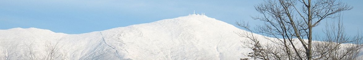
The highest peak in the White Mountains and the most prominent peak east of the Mississippi, Mount Washington is affectionately known as the ‘the Rock Pile’, thanks to the large, loose rocks that make up the summit.
Name: Mount Washington
Height: 1,917 m (6,288 ft)
Location: Part of the Presidential Range of the White Mountains, New Hampshire, USA.
First Climbed: June 1642 by Darby Field and two Native Americans.
Climb Time: 8-12 hours (all listed routes can be completed within a day).
Best Time to Climb: May to August (for summer hiking), October to March (for winter climbing).
Introduction to Mt. Washington
But Mount Washington is probably best known for its extreme and erratic weather. The US Forestry Service even erects signs on the mountain warning hikers of the ‘worst weather in America’ The White Mountains, the larger range in which Mount Washington resides, were described by early explorers as ‘a vast howling wilderness’. Inviting!
Jump to Hiking / Trekking and Climbing Guide
Most notable among its meteorological claims to fame are its record-breaking wind speeds. But less well known is the mountain summit’s status as one of the snowiest places in the eastern United States and that it’s colder on average than Mount Rainier (4,392m/ 14,411 ft), despite being nearly 2,477m (8,127 ft) shorter!
Named after the US’s first president, George Washington, the mountain sits amongst esteemed company. Included the same range is: Mount Adams (1,766 m/ 5,793 ft), Mount Jefferson (1,741 m/ 5,712 ft), Mount Franklin (1,525m/ 5,003 ft) and Mount Eisenhower (1,450 m/ 4,760 ft).
History of Mount Washington.
The Native American name for Mount Washington is ‘Agiocochook’, meaning ‘Home of the Great Spirit’ or, perhaps more appropriately, ‘Mother Goddess of the Storm’.
The Algonquian Indians called it ‘Waumbik’, simply meaning ‘white rocks’. Another name offered for the mountain is ‘Kodaak Wadjo’, meaning ‘the top is hidden’. Both of these names reflect the presence of the weather in the nature of this mountain.
Mount Washington, as we know it, was named after the first US president George Washington, though the exact date of this name is unclear.
Mount Washington is in the meteorological record books. One of the highest wind velocities ever recorded occurred at the summit on 12 April 1934: 372 k/mh (231 mph).
It is only one of the fastest as remote sensors on Barrow Island clocked 407 k/mh (253 mph) winds during Typhoon Olivia. However, Mount Washington’s record gust is the fastest ever observed by man and the fastest ever recorded in the northern and western hemispheres.
Geography of Mount Washington.
Located within the White Mountain National Forest, Mount Washington is the highest point in New Hampshire and of the White Mountains.
It sits within the 30-mile long Presidential Range; also home to the next four highest mountains in New England and consisting of mountains named after former US presidents. Previously, this stretch was simply known as the Mount Washington Massif.
The White Mountains are a 140 km (87 mile) segment of the 3,200 km (2,000 mile) Appalachian Mountains. This huge range stretches from north-east Canada all the way to Alabama, and the White Mountains sit about a third of the way down the chain.
The Appalachian’s are a very old mountain range, with various theories stating they are anywhere from 310 million to 650 million years old.
It is thought most likely that they first formed while part of the ancient supercontinent Pangaea, when the lapetus oceanic plate subducted under the North American plate. Subsequent erosion and further plate and volcanic activity has meant the range has changed shape and height regularly over time, with the current mountains part of activity that occurred during the last 66 million years (Cainozoic Era).
Mt. Washington is mainly formed of New Hampshire quartzite and mica shist. These are both hard, course, granular rock types formed by extremely high temperatures and pressures. These rocks are easily observed at the bottom of ravines, notches and at the summit, where they are scattered in such a way as to inspired the mountain’s nickname: ‘The Rock Pile’.
Mount Washington has a treeless summit, thanks to the strong winds and heavy snowfall preventing any trees from getting a foothold. The buildings at the summit, including an observatory, are all strongly, and necessarily, anchored against the high winds.
Though less evident on the ground, Mount Washington receives heavy snowfall, averaging 6.6 m (21.75 ft) per year. Most of this snow is promptly blown off into the ravines below the summit, much to the delight of skiers and snowboarders enjoying the slopes below.
A local term ‘notches’ describes the glacier-carved ravines and valleys that run down and around the slopes of Mount Washington. The best-known notches near Mount Washington are Crawford (south-west) and Pinkham (south-east), the latter dividing this range from the Wildcat range.
Other well-known notches, such as Dixville, Franconia and Kinsman, are found to the north and east in the White Mountains.
Mount Washington feeds three rivers: the Androscoggin, the Connecticut and the Saco. The Androscoggin winds a 280 km (175 mile) course south and east to the Atlantic Ocean. Its name comes from an Algonquian Indian word meaning ‘fish-curing place’.
Wildlife of Mount Washington.
Flora.
Mt. Washington is part of the White Mountain National Forest. That flora exists in the higher reaches of this mountain at all is testament to their determined adaptations. Many of those species found in the alpine zone are only found again hundreds of miles to the north on the tundra.
At the base of the mountain, deciduous forests are populated by sugar maple, American beech and yellow birch. Red maple, red oak, black cherry, paper birch, white pine and hemlock (though not to be confused with the poison drunk by Socrates) are also scattered through this area.
Above 800 m (approx. 2,650 ft) the make-up of the forests change to spruce, fir and evergreen conifers, before changing to balsam fir around 1,200 m (4,000 ft).
At the tree line, more unusual trees are found, reflecting the extreme weather they experience.
Known as Krummholz or ‘crooked wood’, mainly dwarf and misshapen trees grow. Those that grow vertically have branches only on one side while many form prostrate mats, growing more like bushes, as if ducking to avoid the fierce wind.
Above this, in excess of 115 plant species are surprisingly found in the hostile alpine zone.
One of the endemic species found here is the Dwarf cinquefoil or Robbins’ cinquefoil. A member of the rose family, these fragile yellow flowers are protected following their appearance on the endangered list from 1980 to 2002. They are only found near the summit of Mount Washington.
The best time of year to visit – from a botanical perspective – is early summer (June / July) when the majority of flowers bloom for their short season.
Fauna.
As with the flora, the animals that live on Mount Washington are hardy types. The largest of them are moose and black bears.
The moose, with their huge antlers (males only) and long faces, are a symbol of the northern reaches of North America. However, their population is in decline, falling by 40% over the past decade. Heat and disease are having major impacts on these huge but fragile creatures, so any sightings on Mount Washington are becoming increasingly valuable.
The black bear is found mainly in the forested areas, although some have also wandered into nearby towns! It has a varied diet that, as is common across the US, includes scavenging food left in bags and cars. Heed the warning and carry your food with you, leaving it in bear-proof lockers overnight.
White-tailed deer can also be found on at a range of elevations. Deer in general are populous throughout this region and are one of the most popular animals hunted. The hunting season lasts between September and December.
Wild ducks and geese can be seen during the summer months in the forests, the surrounding lakes or flying in organised V’s overhead.
First Ascent of Mount Washington.
The first ascent of Mount Washington was very early compared to many other peaks. With the majority of peaks first climbed in the 19th and early 20th Centuries, Mount Washington could be seen as an alpine forerunner!
In June 1642, Darby Field, along with two Native Americans, climbed Mount Washington.
His expedition in no small way politically motivated. He wanted to prove to the local Abenaki chief Passaconaway that he was not subject to the same rules as the indigenous peoples.
The locals didn’t climb to the summit of mountains, as they believed the summits were the realms of their gods. By climbing the mountain, Field seemed to assist the colonists’ northern expansion, and their dismissal of any indigenous beliefs as important.
He summitted again in October of the same year to draw the maps of the local area, maps and write more accurate accounts. These were subsequently used by the handful of other adventurers who attempted the climb over the following 150 years.
Climbing guide to Mt. Washington.
Perhaps because of the uneven rocks on this rock pile, winter is a popular option for heading up this mountain. Heavy snowfall evens the ground out somewhat (though necessitating crampons) and allows for the possibility of ice climbing and skiing too.
Whatever time of year you visit, Mount Washington’s weather is something you’d be wise not to underestimate or challenge. Stay up-to-date with current conditions via Mount Washington observatory’s website.
Between 1849 and 2010, 137 people have died on these slopes. While it is far from the world’s deadliest mountain (that dubious honour goes to Annapurna with its 35% death rate), it’s also one to still treat with due respect.
There are a number different hiking trails listed in the area, alongside rock and ice climbing locations and popular ski slopes. Trails criss-cross the mountain, allowing for you to design circular routes as well as the straightforward returns we list below.
Three of the main routes approach Mount Washington from the south-east, beginning at the trailhead located at the Pinkham Notch visitor centre.
The Tuckerman Ravine trail is a 13.5km (8.4 mile) day-return hike from Pinkham Notch.
It begins with a ‘moderate but relentless climb’ of 3.8 km (2.4 miles) to Hermit Lake (1,181 m/ 3875 ft) during which 557 m (1,825 ft) is gained. From here, you head straight up the trail on the west side of the ravine, passed the vibrant green (or white in winter) Tuckerman Bowl, to climb the headwall.
After 1.9 km (1.2 miles) you reach Tuckerman junction, where five different routes intersect. Head north for the final part of the climb, bounding over the boulders that mark out this final ascent section.
During winter, this ravine has a high risk of avalanches, so while doable, this route is recommended more as an adventure for summer.
The Lion Head trail is a favoured winter climbing option, rated at Class 2. It begins by following the Tuckerman Ravine trail before taking the Lion Head route at Huntington Fire road. This begins flat but becomes steep, remaining so for much of the climb up to the top of Lion Head: a rocky outcrop on the right of Tuckerman Ravine.
From here it is a gentler hike along the north rim of the Tuckerman Ravine to re-join the Tuckerman Ravine trail for the final kilometre to the summit.
A straight return is a little less than 14 km (8.6 miles), so allow for a full day of hiking.
The Huntington Ravine trail is a more challenging prospect altogether.
It is considered one of the most difficult hikes in the White Mountains, sometimes referred to as more of a non-technical rock climb than a hike. With good reason: there are sections that follow very minimal paths, narrow ledges and a Class 3 climb up a big slab (though ropes are rarely necessary).
The Huntington Ravine trail begins 2.1 km (1.3 miles) up the Tuckerman Ravine trail, where it branches off to the right. After a further 2.4 km (1.5 miles) of rocks and bushes, you reach the boulder field at the bottom of the ravine. The trail is not difficult and is followed via the painted marks on the rocks, leading to a steeper slope with loose rocks known as the Fan.
This leads to the Class 3 section that, while not technically difficult, does involve heading more-or-less straight up the rock face. At the top, you reach the Alpine Garden plateau, with a variety of routes to pick to get to the summit (approx. 200 m/ 700 ft of further elevation).
Again, this trail is one for summer as the ravine has a high avalanche risk in winter. However, ice climbing is also a popular winter activity in this mountain ravine. Be aware that the exposed top of the ravine can be very dangerous, (climbers have been known to literally be blown off the mountain here, which is no joke).
The summit is also accessible by the Mount Washington Auto Road, a 12.2 km (7.6 mile) road from Highway 16 at Pinkham North to the summit. Various vehicle and sports events happen on this road annually. Note that a permit is required to drive up and restrictions to vehicles and times apply.
A cog railway, built in 1869 and known locally as ’the Cog’, runs from northeast of Crawford Notch. As a three-hour return (an hour each way and an hour spent on the summit), this is a definite tourist activity, with commentary and history accompanying the spectacular views.
Information on HIking around Mount Washington.
As the majority of mountains in the wider White Mountains barely reach above the tree line, there are a plethora of options for trekking throughout the region, whatever level of challenge you’re after.
Many of the trails below the tree line will be called ‘nature trails’. There are over 1,600 km (1,000 miles) of these winding throughout the White Mountains.
Plenty of campsites also make the logistics of a multi-day adventure a simple affair. As the area is a favourite summer vacation destination, be sure to check when and where is busiest and plan accordingly.
For more challenging hikes, the White Mountains are full of excellent ascents, looped routes and hikes. The Franconia Ridge loop (14.5 km/ 9 miles) is seen as a classic White Mountain hike: climb up through a notch to walk along a ridge line, collect a couple of summits and enjoy some spectacular views.
For a shorter option, the Welch-Dickey loop (7.25 km/ 4.5 miles) climbs up to two summits (half a kilometre apart) which offer great views to the south and west, and is suitable to attempt year-round.
The southern Presidential Range, the range in which Mount Washington sits, has some other high peaks with a variety of traverse and hut-to-hut options alongside straightforward ascents.
One option is the Presi Traverse, a day-long hike where at least nine of the range’s summits are reached. Starting at 4am, this hike is something of a race against daylight – one most often won around the summer solstice (June). Estimated times for this vary between 14 to 17 hours.