

One of the Colorado 14ers, Snowmass Mountain is also home to crystal clear lakes and some great backcountry hiking options.
Name: Snowmass Mountain
Height: 4,295 m (14,092 ft)
Location: Elk Mountains in Colorado, USA
First Climbed: 7 August 1873 by W Byers, W Rideling and J Gardner.
Climb Time: 1-2 days
Best Time to Climb: April-June or June-September, depending on route.
INTRODUCTION TO SNOWMASS MOUNTAIN
Snowmass Mountain (4,295 m/ 14,092 ft) is an isolated peak in central Colorado, flanked by the enormous snowfield that gave it its name.
Known to the Ute people as the Cold Woman, this mountain’s summit is often shrouded in cloud, apparently divining the next downpour. Away to the north-east is the famous ski town of Aspen, surrounded by resorts that draw thousands to the slopes each winter.
Jump to Climbing and Hiking Guide
With challenging hiking and climbing on and around this mountain, ranging from class III-V, Snowmass is an adventure mountain that’ll have you scrambling time and again to gain those panoramic summit views.
From this mountain top, stare out on a rugged landscape in all directions that will undoubtedly take your breath away.
HISTORY OF SNOWMASS MOUNTAIN
Today, Snowmass Mountain is more commonly confused by sight and name with other prominent features that reside nearby.
Snowmass Peak lies to the south. With a more prominent, steep summit and a close proximity to the popular camping spot of Snowmass Lake, it is often confused with its taller neighbour.
Equally, Snowmass ski resort lies some distance to the north-east of the mountain near Aspen, the hub of world-class skiing in the area. This resort is far closer to Burnt Mountain (3,541 m/ 11,617 ft), though no doubt borrows the Snowmass name for its obvious appeal to vacationing skiers.
Finally, there are two places called Snowmass, one a village and the other a town. Both lie to the north-east with the village being a popular ski destination. To confuse things further, one village website reads “the town of Snowmass village”.
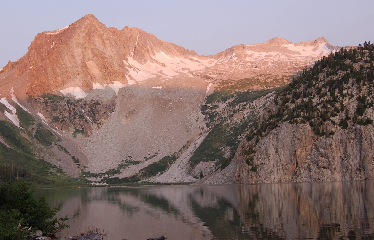
Hagerman Peak on the left and Snowmass Mountain on the right.
Should you visit the area, do take extra care to end up in the place you intended to!
The mountain was named by surveyors of the Hayden Survey who made the peak’s first recorded ascent (see below). It is named after the vast snowfield that covers the massif’s eastern flanks, leading down to Snowmass Lake.
Yet other names for the peak existed before this. Early pioneers called it The Twins, due to its appearance as having two distinct summits (the other being today’s Snowmass Peak).
The local indigenous population, the Utes, called it Cold Woman, blaming the mountain whose summit is regularly shrouded in cloud, for bad weather in the region.
Surrounding the peak, the Maroon Bells-Snowmass Wilderness area (see below) is one of the most visited wilderness areas in Colorado. It is centred around a north to south line of peaks from Capitol Peak down to Maroon Peak and contains numerous wooded valleys, ponds, lakes and, of course, mountains.
GEOGRAPHY OF SNOWMASS MOUNTAIN
Snowmass Mountain is one of the most isolated of the Colorado 14ers. It cannot be seen from any road and to reach the trailhead for the most popular hike, for example, you must first hike 13 km (8.1 miles) up Snowmass Creek from the nearest car park to reach Snowmass Lake.
A regular victim of mistaken identity, Snowmass Mountain is often confused with its near neighbours: Snowmass Peak (4,151 m/ 13,620 ft) and Hagerman Peak (4,219 m/ 13,841 ft). Both of these peaks are arguably more striking in appearance, and when viewed from Snowmass Lake, both appear higher than Snowmass Mountain.
And yet Snowmass Mountain is higher than both, as well as most of the Elk Mountains. This range is part of the long Rocky Mountains range, the collection of ranges that runs across much of central USA and on into Canada.
These were formed around the time of the dinosaurs’ extinction, rising the ancestral Rockies up out of the sea bed where they had lain for some time. You can read more on the formation of these peaks in our Rocky Mountains article.
Elk Mountains
Snowmass Mountain is the fourth highest peak in the rugged Elk Mountains and ranks 31st in the Colorado fourteeners. Of the multiple ranges (between six and twelve depending on the definition you follow) on the 14ers, the Elk Mountains are the most north-westerly, nearest to the long Sawatch Range.
The other fourteeners in the Elk Range are:
• Castle Peak: 4,348 m (14,265 ft)
• Maroon Peak: 4,315 m (14,156 ft)
• Capitol Peak: 4,307 m (14,130 ft)
• Pyramid Peak: 4,273 m (14,018 ft)
• North Maroon Peak: 4,271 m (14,014 ft)
Maroon Peak lies 8 km (5 miles) to the south-east at the opposite end of Snowmass Creek, while Capitol Peak lies 3.2 km (2 miles) to the north-east, accessible via a frighteningly thin ridgeline. This can be crossed via a thrilling class V traverse.
Snowmass Snowfield and Wilderness Area
On the eastern side of Snowmass mountain lies a sprawling snowfield, after which this mountain is named. It is one of the largest in Colorado and is used for the majority of the typical ascent route to the summit. This area is covered in snow from October-June each year, and stretches from the summit of Snowmass Mountain to within touching distance of Snowmass Lake.
Snowmass Mountain lies with the Maroon Bells-Snowmass Wilderness of central Colorado. Established in 1980, it contains over 160 km (99.5 miles) of hiking trails, six fourteeners and nine mountain passes above 3,700 m (12,140 ft). All hikers must register with the US Forest Service on entry, though no fees are charged (they use the data simply to track usage of the area).
To the south-west of the mountain lies Geneva Lake and to the south-east is Snowmass Lake, a larger lake often used as the overnight stop on summit hikes. These lakes feature prominently on hiking routes, and are linked via the Trail Rider Pass to the south of the massif.
WILDLIFE OF SNOWMASS MOUNTAIN
Flora.
In the valleys below Snowmass Mountain, Engelmann spruce predominates, living in the rich soil that is fed by the regular rains, snowmelt and flowing rivers. Depending on the time of year, some of the valley floors can be once almost marsh-like, so be sure to check before heading out (or you’ll be testing out how waterproof those new boots are!)
Higher up, subalpine firs take over with gaps between them populated by alpine meadows. Eventually, this passes into the alpine tundra of the upper mountain slopes.
The steep sides of these peaks don’t allow much to grow on the higher reaches. Equally, the eastern slopes, snow covered for much of the year, have a very limited amount of flora present.
Yet below the mountain, surrounding the lakes and running through the valleys and creeks, are a wide array of colourful wildflowers, which bloom in the spring when most hikers prefer to adventure here. Blue columbine, Indian paintbrush and alpine sunflowers all find a footing and decorate the trekkers’ days.
Smaller plants such as moss pink campion, alpine sandwort and alpine forget-me-not are also found across the valleys and lower slopes. American bistort is distinctive with its white seed pods that are wind dispersed, very similar to the common British dandelion.
Fauna.
Typical of the wider area, the fauna of Snowmass Mountain and its wilderness area, contains a typical mix of American mountain fauna.
Mule deer, moose, elk, black bears, mountain lions and coyotes are some of the larger creatures, while bighorn sheep are easily spotted on the slopes. In summer, marmots and pikas can be spotted running swiftly between their hiding places.
In nearby Aspen and Snowmass village, bear sightings are big news, though this is certainly not always positive.
Drawn to the town during periods when the snow lies longer on the ground and food resources are scarce in nature, they scavenge leftovers and rubbish. Generally avoiding humans, several bears still have to be ‘euthanised’ each year for coming a little too close to those all-conquering invaders of their territory—us.
Yet moose potentially pose an even larger problem to humans. Threatened by wolves in nature, they are known to attack domestic dogs as well as their human owners, recognising the allegiance as a type of pack.
As such, wildlife education is something that locals take very seriously. You’d be advised to listen to carefully, and follow guidelines, when you visit.
FIRST ASCENT OF SNOWMASS MOUNTAIN
Snowmass Mountain was first climbed by William Byers, W Rideling and James Gardner on the 7 August 1873.
The three of them were surveyors for the Hayden Geological Survey, which began in Yellowstone in 1871. This survey helped define Yellowstone National Park, which was designated the following year, before it headed down to map out wild Colorado.
It is from these first summiteers that the mountain got its name, ignoring the offerings from the local people or early pioneers (see above).
CLIMBING GUIDE FOR SNOWMASS MOUNTAIN
Hiking on Snowmass is better taken in the spring and early summer (April-June), when the snowfield still covers much of the route. As such, an ice axe and crampons are recommended when climbing Snowmass Mountain.
Later in the summer, the melted snow reveals a scree-covered route and the risk of rockfall increases. This makes the route more strenuous and more treacherous. You would be advised to consider alternative routes up the mountain from mid-summer onwards.
Approaches
The Snowmass Creek approach is the typical route taken to arrive at the base of most summit attempts. It is a 13 km (8.1 miles) trail beginning at the Snowmass Creek trailhead, found in a well signposted car park at the end of Snowmass CreekRoad. To reach Snowmass Lake, you follow signs for the Maroon-Snowmass Trail.
A more strenuous, though shorter option is the Buckskin Pass approach, crossing one of the highest passes in the area. Beginning at the Maroon Lake trailhead in the south-east, head to Crater Lake then head up the Minnehaha Gulch to reach Buckskin Pass, and descend and cross over Snowmass Creek to reach Snowmass Lake.
- Browse a list of books about the Colorado 14ers
- Read our profile of the Colorado 14ers.
- Top Long-Distance Hikes in North America.
Hiking Routes
The Normal Route, beginning at Snowmass Lake, is the easiest of the routes up the mountain, yet is still rated as a class III climb. It climbs the eastern slopes from Snowmass Lake and is, more or less, a straight shot from lake to summit.
From the campsite, head along the south of the lake, following the route around to the western shore, with the mountains to your left. If you continue straight along the trail from the south of the lake and begin climbing, then you’re headed from Trail Rider Pass, which leads across the south of the massif.
Once on the slope (wether its a snowfield or scree), keep to the left of the gully and head for the summit directly above you. The route is marked by cairns in the summer and by the visible end point in spring. In the final part of the ascent, choose between the more difficult but shorter direct route straight up the gully or a longer route around to the left of the summit.
The shorter route requires some scrambling up 45º slopes. On snow, use an ice axe, or on scree, wear a helmet. The longer route is the normal route, and gains the summit ridgeline 400 m (1,312 ft) to the south. The final part of this ascent is a sustained class III effort along a very narrow ridgeline. So, whichever choice you make, challenges will abound.
The Normal Route is an 8-10 hour return at 10.5 km (6.5 miles), with the descent route the same as the ascent.
A less difficult prospect, also rated at class III, and much shorter than the Normal Route, is the S Ridge Route.
A 14.5 km (9-mile) return from Lead King Basin trailhead, which is reachable by car, it is a more stable route and a better choice for mid- to late summer hiking.
Beginning at the trailhead (2,966 m/ 9,730 ft), head north to reach Geneva Lake, with the ridgeline in view up ahead of you. Follow the western shore of Geneva Lake and begin climbing a series of small hills, following directions for Camp #4, eventually reaching Little Gem Lake.
A direct route is then taken, off-trail, toward the summit of Snowmass Mountain. Crossing the valley floor, you then begin climbing up the rocky gully that begins Snowmass’ western face. Towards the top, head right and traverse the rocky slope to gain the next gullies.
Taking either gully, you gain the southern end of the ridgeline and begin a classic class III scramble north, following the ridgeline all the way to the Snowmass Mountain summit. Stay as close to the centre of the ridge as possible, as straying off the ridgeline leads to loose rock and an increased risk of falling.
Descend via the same route, or alternatively follow the Normal Route down to Snowmass Lake.
A far less trodden route climbs the western flanks of Snowmass Mountain, beginning at the diminutive Geneva Lake to the summit’s south-west. This is accessed via the North Fork of the Crystal river, and could be added on to the Four Pass Loop hike (see below) or follow the Lead King Basin approach, beginning at the Crystal trailhead.
This follows a similar approach to the S Ridge Route, but climbs the more challenging West Rib and West Face, directly towards the summit. This scrambling is tougher and borders on requiring some decent bouldering skills.
INFORMATION ON HiKING AROUND SNOWMASS MOUNTAIN
In the Maroon Bells-Snowmass Wilderness area, one of the more challenging but more thrilling hikes is called the Four Pass Loop. Surprisingly enough, this five day circuit passes over some of the highest passes in the region, reaching a high point of 3,798 m (12,462 ft) at Buckskin Pass.
The route passes closest to Snowmass Mountain via the Trail Rider Pass, to the south-east of the massif, before skirting the south of Snowmass Lake. It tours by waterfalls, wildflower valleys and the temptingly-named Crystal River, beginning and ending the trek at Maroon Lake.
- Browse a list of books about the Colorado 14ers
- Top Long-Distance Hikes in North America.
- What to take on a hike?
In terms of other mountains to climb in the Elk Mountiains, only Castle Peak is rated as easier, a class II hike. Many are rated equal to or above Snowmass Mountain, reflecting the rugged, challenging landscape in which it stands. Nearby Capitol Peak, for example, is a class IV ascent and the traverse between these summits is rated as class V.
Further afield, the Colorado 14ers do contain a few easier ascents. Mount Elbert (4,401 m/ 14,440 ft), the group’s highest peak, is only a class II hike, essentially a walk-up. Mount Bierstadt (4,286 m/ 14,060 ft) and Grays Peak (4,350 m/ 14,270 ft) are simpler still, both offering a class I option. The simplest Colorado ascent of all is Pikes Peak (4,302 m/ 14,155 ft), where you can drive straight to the summit!
With such a vast range of trekking and climbing options in Colorado, centred around this special group of high peaks, you’ll never be short of adventure near Snowmass Mountain