
Xinjiang Tianshan comprises four components—Tomur, Kalajun-Kuerdening, Bayinbukuke and Bogda. They are part of the Tianshan mountain system of Central Asia, one of the largest mountain ranges in the world.
Name: Tian Shan (Also known as the Tengri Tagh)
Height: 7,439 metres (24,406 ft)
Location: Central Asia (extends through western China, Kazakhstan, and Kyrgyzstan)
Climb Time: Around 21 days
Best Time to Climb: Spring and early summer during foaling season
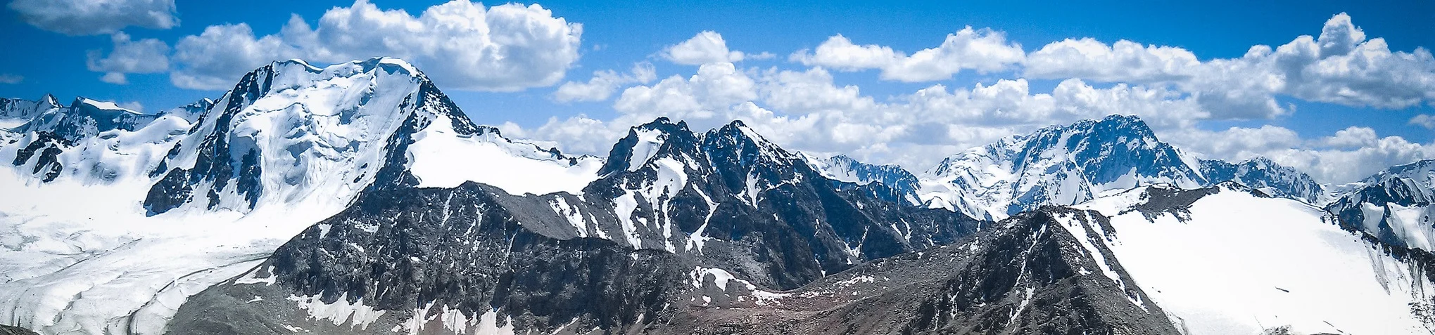
The Tian Shan, also known as the Tengri Tagh, meaning the Mountains of Heaven or the Heavenly Mountain, is a large system of mountain ranges located in Central Asia. It extends through western China, Kazakhstan, and Kyrgyzstan.
Tian Shan is 2,800 kilometres (1,700 mi) long, and up to 7,400 metres (24,300 ft) high. Throughout the Tian Shan there are several intermountain basins separated by high ranges. Plate tectonic theory makes the assumption that deformation is concentrated along plate boundaries. However, active deformation is observed in the Tian Shan, far from plate boundaries. This apparent contradiction of plate tectonic theory makes the Tian Shan a key place to study the dynamics of intracontinental deformation.
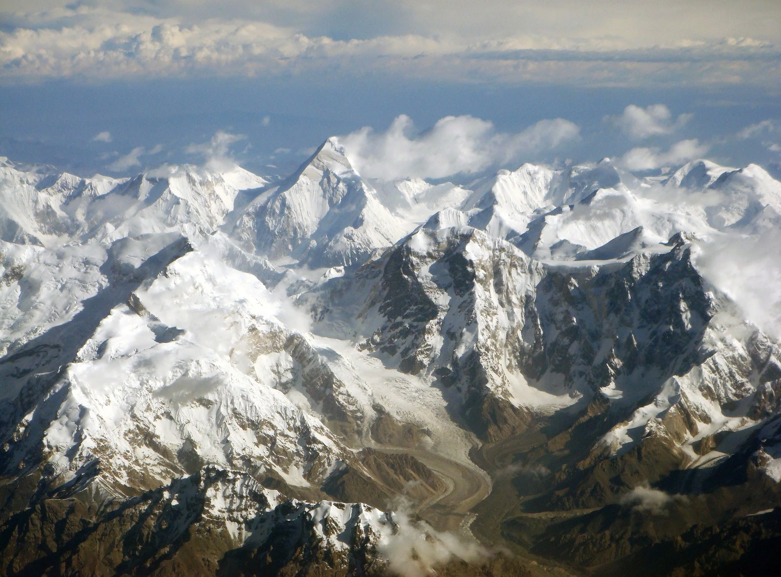
Jengish Chokusu ( More known as Пик Победы: Victory Peak) is the highest mountain in the Tian Shan mountain system at 7,439 metres (24,406 ft). It lays on the Kyrgyzstan–China border, in the Kakshaal Too, the highest part of the Tien Shan, southeast of lake Issyk Kul.
The Khan Tengri was believed to be the highest peak in the range until Jengish Chokusu's survey in 1946, where it was found that Jengish Chokusu was 400 meters (1312.34 ft) higher then Khan Tengri .
A large-scale attempt on the Jengish Chokusu peak in 1955 was disastrous, when 11 expedition members were killed in a blizzard. Jengish Chokusu's first indisputably verified ascent was in 1956 by Vitaly Abalakov's party. A Chinese expedition climbed the peak from the Chinese side in 1977.
The Tian Shan, also known as the Tengri Tagh, meaning the Mountains of Heaven or the Heavenly Mountain, is a large system of mountain ranges located in Central Asia. It extends through western China, Kazakhstan, and Kyrgyzstan.
Tian Shan is 2,800 kilometres (1,700 mi) long, and up to 7,400 metres (24,300 ft) high. Throughout the Tian Shan there are several intermountain basins separated by high ranges. Plate tectonic theory makes the assumption that deformation is concentrated along plate boundaries. However, active deformation is observed in the Tian Shan, far from plate boundaries. This apparent contradiction of plate tectonic theory makes the Tian Shan a key place to study the dynamics of intracontinental deformation.
Jengish Chokusu ( More known as Пик Победы: Victory Peak) is the highest mountain in the Tian Shan mountain system at 7,439 metres (24,406 ft). It lays on the Kyrgyzstan–China border, in the Kakshaal Too, the highest part of the Tien Shan, southeast of lake Issyk Kul.
The Khan Tengri was believed to be the highest peak in the range until Jengish Chokusu's survey in 1946, where it was found that Jengish Chokusu was 400 meters (1312.34 ft) higher then Khan Tengri .
A large-scale attempt on the Jengish Chokusu peak in 1955 was disastrous, when 11 expedition members were killed in a blizzard. Jengish Chokusu's first indisputably verified ascent was in 1956 by Vitaly Abalakov's party. A Chinese expedition climbed the peak from the Chinese side in 1977.
Among all the other peaks of the grand Tien Shan mountain range Pobeda Peak overranges them with more than 400 meters. Having complex and broad structure, this peak produces the most reverential impression on people. Climbing this mountain is not an easy task as it is considered the “ the coldest mountain on earth". Most routes up start from the Northwest and West and in fact it’s one of the northest 7000 peaks in the world. Because of all these factors climbers experience an additional difficulty in reaching it.
Second highest is Khan Tengri the other peak over 7000m. These two are the northest mountains of this elevation. There are many other high border peaks, which can be climbed from the Chinese side. It's a very uncommon option and be prepared for a pioneering feeling heading into this seldom visited range.
The central part consists of two parallel ranges, with a lush green high plateau in between. All peaks here are below 6000m. There are very few roads crossing the plateau and off these, you have to go with 4x4 or on horseback. Despite this, travelling is quite straight forward as most areas consist of huge plains of grass. When in the actual ranges, the topography is rugged and deep valleys and steep mountain sides effectively blocks the way for anyone but the most determined.
Tien Shan Mountains is also one of the few places in the world where you can spot the highly endangered and incredibly elusive snow leopard. If you see one it just might be for a second, so keep your eyes out for this animal, since people who see them are considered very lucky to have seen one in their entire lifetime.
Climbing guide:
Peaks below 6000 meters (19685.04ft):
Most peaks can be climbed without a permit, but you do have to pay a $50 fee for climbing any peak below 6000m. There is a very strange situation for this rule since this rule only applies for the peaks that are "mountains"(?) But usually you only need a permit for the highest peaks in the Bogda Shan.
Peaks over 6000 meters (19685.04ft):
For all the peaks over 6000 meters you need a permit which you can get at CMA - Chinese Mountaineering Association.
The price for the highest peak (Pik Pobede) is around $1080. The price is based on a 12 person group.
You may also encounter some fees for nature preservation in some areas.
Hiking guide:
Tian Shan is one of the best places to go hiking if you want some solitude.
You can go hiking for days or even weeks without seeing a single person, but it is not recommended to go without a guide since there are many stories of people getting lost, never to return. Unlike other mountain ranges, like the Alps in Europe, many trails in the Tien Shan Mountains are not well signed or marked!
Tian Shan is much more isolated then other mountains so getting help can take days or even weeks for another person to appear.
For more information about travelling and trekking in Tian Shan check out these links:
https://silkroadexplore.com/trekking-tour-contrasts-of-tien-shan/
http://www.tien-shan.com/

LATEST BLOG POSTS
I quit the rat-race to live a more adventurous life. This is my journey.