
If you were to stand on top of Chimborazo (6,310 m/ 20,702 ft) in the Andes of South America, you would be as far from the Earth’s centre as it is possible to be; farther even than the mighty Mount Everest.
Name: Chimborazo
Height: 6,310 m (20,702 ft) (contested)
Location: In the northern Andes, Ecuador, South America.
First Climbed: 4 January 1880 by E Whymper and the Carrel brothers.
Climb Time: 2 - 3 days.
Best Time to Climb: June-July and December-January.
INTRODUCTION TO CHIMBORAZO.
Head north from Chimborazo through the Americas and you will not find a higher peak. This mountain is offers challenges of altitude and ice trekking, with heavily glaciated slopes lining the route to the summit, whichever direction you choose for your approach.
Jump to Climbing or Trekking Guide
With some fascinating stories from recent history, and one traditional industry that is sadly in decline along with the glaciers, Chimborazo is worth putting on the South American bucket list. Its lesser popularity when compared to other Andean peaks like Aconcagua (6,959 m/ 22,831 ft) makes it an unusual and rewarding boast for any would-be adventurer.
HISTORY OF CHIMBORAZO.
The name Chimborazo translates as ‘the snow on the other side’ or ‘women of ice’. Another name for the peak is Urcurazu, which means ‘mountain of ice’. The exact origins of Chimborazo and its meaning are unclear, with some attributing it to the Cayapa language, while others believe it is Quechuan or Spanish.
In the highlands of Chimborazo, the indigenous Quechua, or Quichua, people vastly pre-date the arrival of the Spanish in the late 15th Century. Quechua is actually the name of the language shared by a number of tribes across the region. In their mythology, Chimborazo represents the divine Father, Taita, while nearby Mount Tungurahua (5,023 m/ 16,480 ft) is the Mother, Mama.
- Read our Guide to the Andes
- Browse a list of books and guidebooks on the Andes
- Read our Guide to Aconcagua
If these indigenous people are anything like the Incas, who mainly lived farther the south, they may well have been the first to summit of Chimborazo. There is accepted evidence that the Incas climbed Llullaillaco (6,739 m/ 22,110 ft), long before the arrival of Columbus. This stratovolcano is found on the border between Chile and Argentina, as many of the Andean mountains are.

The ice from the glaciers was traditionally mined by hand and carried from the mountain to be sold at market. Thishas been a common practice across many of the glaciated peaks of Equador, carried out by Hierleros, a name derived from the Spanish word for ice, Hielo.
However, in recent years the practice has become less common, as the demand for such ice has decreased with advances in technology making ice-making machines so easily and cheaply available. This article describes a meeting with one of the last ice merchants, as he attempts to maintain what is bound to soon become a lost tradition.
On 10 November 1993, Chimborazo was the site of one of Ecuador’s worst climbing disasters. Seven French climbers and three Ecuadorian guides were caught in a devastating avalanche, which are common on this peak of ice and snow. Most of the climbers were defined as missing, presumed dead as many of the bodies weren’t recovered. However, in 2015, three of those missing were recovered and identified, found frozen in ice on the slopes 12 years after their falls.
It is also the site of a missing flight, which disappeared in August 1976. SAETA flight 232 left on its daily journey south from Quito to Cuenca, but never arrived. The fate of the 59 people onboard was only revealed when the wreckage was found in 2002, finally revealed by the glaciers which had encased it.
GEOGRAPHY OF CHIMBORAZO.
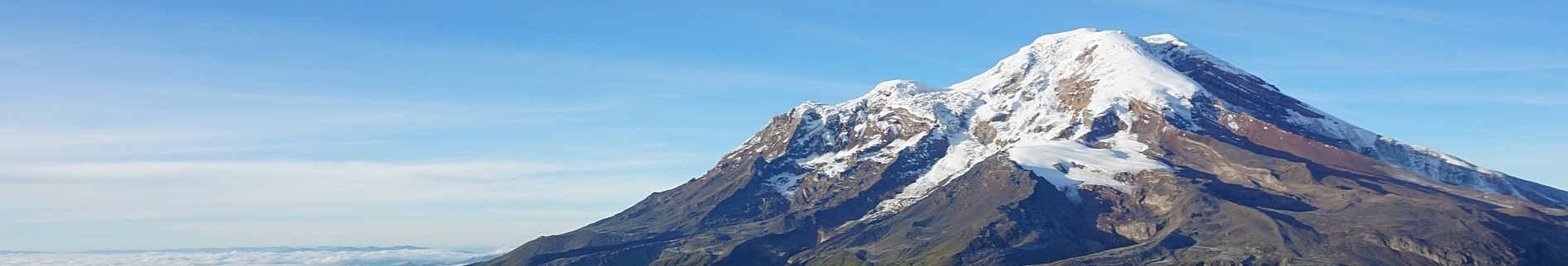
Considered an inactive, though not extinct, stratovolcano, Chimborazo is a something of a record breaker, though lacking in the fame this might afford it.
The mountaintop is covered in glaciers, with the 18th highest prominence in the world. Its slopes are largely barren, yet it rises as a magnificent centrepiece as the highest point in Ecuador’s Andes mountains.
Around 35,000 years ago, the volcano collapsed in on itself. Masses of debris was sent tumbling from the mountain and spread many kilometres from the peak. Its current footprint has a diameter of approximately 48 km (30 miles). More recently, Chimborazo has erupted across at least seven periods in the last 10,000 years, with the last eruption occurring around 500AD. These allowed it to regain some of the height lost in the previous collapse.
It has five summits, the central one being the true summit. Its ridge-line runs east to west, with a saddle between the central and easterly summits dropping around 400 m (1,300 ft) below the high point. The high point is Cumbre Whymper/Maxima, though the often quoted summit height taken in 1993 actually refers to the second highest point, Cumbre Veintimilla. We have used the accepted, though not unofficial, higher measurement in this report (6,310 m/ 20,702 ft).
Highest point on Earth.
The most extraordinary fact about Chimborazo is its status as the farthest point from the centre of the Earth. But as it is not even the highest point in the Andes, how can this be?
While the idea of the Earth being flat has long since been disproved, the shape many of us might hold in our minds is of the earth as a perfect sphere. But not so.
The Earth is actually an oblate spheroid, making it somewhere between a sphere to an egg shape. As such, the Earth is fattest around the equator, so the mountains lying near to this latitude are consequently farther away from the Earth’s molten centre.
Chimaborazo, being only one degree south of the Equator, pokes out of the Earth almost at its thickest part. This makes its summit 2,163 m (7,096 ft) farther from the Earth’s core than Everest, despite being 2,585 m (8,481 ft) lower in normal elevation measurements, which are taken from sea level.
And that is how Chimborazo is, by one measurement, the tallest peak on Earth!
The Andes.
The Andes, a mountain range that runs like a spine down the west coast of South America, is divided in to two main ranges as it crosses Ecuador: the Cordillera Occidental and the Cordillera Real or Central. Chimborazo is a member of the first of these and is the range’s highest peak.
It is also part of the northern Andean Volcanic Arc, and marks the south-west end of the Avenida de los Volcanes (Avenue of Volcanoes). Its nearest neighbour along either of these arcs is Carihuairazo (5,018 m/ 16,463 ft), which lies 9.3 km (5.8 miles) away to the north-east.
Chimborazo has a permanent snow-line at 4,700 m (15,420 ft), has a thick ice cap and is lined with glaciers that reach a little farther down the slopes. These are supported by high rates of precipitation, so the water supply for nearby populations in Ecuador and Bolivia shouldn’t run out anytime soon. The rivers that drain from the mountain are the Ambato, the Chimbo and the Chambo, all of which feed the larger Pastaza river.
So, if you do attempt the challenge of climbing the mountain, you will need an ice axe and crampons in order to safely reach the summit.
However, a combination of global warming and the ash from eruptions of nearby Tungurahua has caused the glaciers to melt and retreat in recent years. This pattern is common around the world, and impacts the local communities who rely on the glacial waters for farming.
WILDLIFE OF CHIMBORAZO.
Flora.
The area around the mountain is part of a designated protected reserve, allowing it to flourish with less human interference. And while the mountain itself, with its iced top and desert-like appearance at lower elevations, boasts very little flora, the surrounding reserve reflects a rich moorland that is typical of the Ecuadorian plains.
Plants found in these moorlands include piquiles, pumamaquis, yaguales, quishuares, signes and chuquiraguas. They tend to be low-lying plants that grow amid the grasses of the moorland. They are all native to the Andes, with some found only within this local region.
The chuquiraguas, for example, are low shrubs with spiky, round orange flowers, and are native to Ecuador and Peru.
On the higher slopes, the minimal flora is scattered more irregularly, but one plant that does survive is the Polylepis. This high altitude, Andean specialist typically grows to the size of a small tree with crooked limbs, and is found at heights above 3,500 m (11,500 ft). As such, it is found from this level up to the snow line on Chimborazo.
Fauna.
The fauna around the mountain are more typically recognisable as quintessentially South American. Alpacas, vicuñas and llamas are found on the slopes and, along with mules, can be put to use carrying loads up the mountains.
They are all types of camelid and are all closely related. The vicuña is thought to be the wild ancestor of the domesticated Alpaca, and both are close relatives of the llama. All have very warm wool, which is much in demand for winter clothes.
The vicuña, whose light-brown, long neck contrasts with their white underbelly, is the national emblem of Peru. These creatures were declared endangered in 1974, but have slowly recovered to have a stable population across the north-west of South America since.
Also found on the peak are wolves, deer, marsupial rats and rabbits, though none quite have the national significance of those named above.
FIRST ASCENT OF CHIMBORAZO.
The first explorations on the peak occurred in 1746, when academics from the French Geodesic Mission discerned the shape of the Earth accurately for the first time, in collaboration with a team in Lapland.
The first summit attempts began in earnest at the start of the 19th Century. In 1802, a famous climber, Baron Alexander von Humboldt, reached higher than any European had climbed to date on the slopes of Chimborazo. Unfortunately he didn’t achieve the summit; he had to turn back around a kilometre from the top.
The first successful ascent occurred sometime later, on the 4 January 1880. Edward Whymper and two Italian guides, Louis and Jean-Antoine Carrel, set a new record as the highest European summiteers at that time; they were the first to successfully climb a peak above 6,096 m (20,000 ft).
The route they took is now known as the Whymper or Original route. It follows the south-west ridge and face to reach the summit.
Whymper also made first ascents of half a dozen other Andean peaks. He was there to primarily explore the effects of altitude in the body, however, and drew some of the first significant conclusions about what caused altitude sickness. This work later gained him the Patron’s medal from the Royal Geographical Society.
While still in South America in 1880, some doubts were voiced as to the validity of his first ascent. In reply, he repeated the climb of Chimborazo, cutting a different route as he went, now known as the Pogyos route up the north side. He succeeded this time with with two Ecuadorians as company, which answered his critics conclusively!
Read more about Whymper in our review of his books, as the Armchair Mountaineer (inadvertently) followed in his footsteps.
CLIMBING GUIDE FOR CHIMBORAZO.
There are many routes up the mountain, approaching from all around the peak’s slopes. Although the majority of these are not highly technical, an understanding of trekking over ice and snow is required.
There are also sections of crevasses and a need for some route finding. As such, heading up with a guide is strongly recommended (make sure you check they have good crevasse rescue training).
- Browse a list of Books and Guidebooks on the Andes
- What is the highest Mountain in Chile?
- What is the Highest Mountain in Argentina?
Most climbers will spend some time acclimatising on nearby peaks, such as Cayambe (4,690 m/ 15,387 ft). This process allows you and your guides to see how you cope with the thin air at altitude before attempting on the higher reaches of Chimborazo. After all, a summit attempt from Whymper refuge (5,000 m/ 16,400 ft) is the equivalent of climbing a little higher than Ben Nevis (1,345 m/ 4,411 ft), but beginning from a height a little higher than Mont Blanc (4,810 m/15,872 ft).
There are other dangers, such as the tendency for rock and ice falls and avalanches on the peak that is slowly being ground down by the enormous glaciers. The predictable, consistent weather of Ecuador is in stark contrast with the violent climactic swings on this mountain.
Climbing Chimborazo is made significantly easier by being able to drive to a trailhead around 4,570 m (14,994 ft), half an hour’s hike from the first of two refuges on the route, Carrel refuge (4,799 m/ 15,744 ft). It is also made cheaper by simply arranging a local guide arrival in Ecuador, rather than using a western operator.
Whymper/Normal route
Although this route does not follow the exact path that Whymper and his colleagues took on their first ascent, it is often referred to by the name of the early explorer.
It is by far the most popular route up the mountain, and leads up to the two highest summits: Cumbre Veintimilla (6,268 m/ 20,564 ft) and Cumbre Whymper (estimated at 6,310 m/ 20,702 ft). In the absence of snow, the route becomes more difficult as the uneven terrain is revealed.
From Whymper Hut, you head to meet the west side of the Thielmann glacier, located to the north-west of the hut. Traversing this glacier, you scramble over loose scree to gain the saddle on a ridge-line up to the west, above a rocky outcrop called El Castillo.
From here, the ridge-line, which becomes increasingly ice-covered, takes you up to the first summit, Veintimilla, positioned north-east of the saddle. This climb is tedious and steep, up to 45 degrees. There are also crevasses, which increase as you climb into the less steep glacial sections.
The traverse to Cumbre Whymper is a further hour from Veintimilla, across a snow-filled basin. This is best traversed early in the day while it is still hard. Later in the day, or after fresh snowfall, this section can be an arduous, thigh-deep trudge through snow.
Other routes
Other routes of similar difficulty include: the North Side route, which was the second one used by Whymper in 1880 and another a route up the North Side via Castillo.
Two of the harder routes are the West Face, which contains sections of 85 degree mixed rock and ice climbing, and Arista del Sol. This is considered the hardest route, requiring two days to complete. The first two thirds of the route is entirely rock climbing; it was first cut in 1983, a century after the first ascent of the mountain.
INFORMATION ON TREKKING AROUND CHIMBORAZO.
One popular alternative trek is to visit a number of the local volcanoes as part of a multi-day tour. To the north and north-east are treks around the mountains of Chimborazo are Cotopaxi (5,897 m/ 19,347 ft), Quilotoa (3,914 m/ 12,841 ft) and Carihuairazo (5,018 m/ 16,463 ft). One is the Quilotoa loop, a three to five day tour through the foothills near this peak. The other side of Quito is Cayambe, a peak used for acclimatisation training, but also host to a number of organised treks.
The emphasis on any guided treks is also engaging and understanding more about the local culture. Varying from 5-14 days, these tend to set you back a couple of thousand US dollars.
Two other famous Ecuadorian challenges are the Inca trail, a 3-day, 45 km (28-mile) adventure that does require a guide, and the Condor trek, which finishes in Cotopaxi National Park and was listed in the National Geographic’s Adventure Bucket List 2014.