
Photo by FluttershyIsMagic
With a rich indigenous mythology connecting it to the region’s impressive landscape, Mount Adams finds itself among a celebratory and fascinating view of nature.
Name: Mount Adams
Other Names: Pahto, Klickitat, Paddo (Native American names)
Height: 3,742 m (12,276 ft)
Location: In the Cascade Range, southern Washington, USA.
First Climbed: 1854 by A G Aiken and two others
Climb Time: 1-2 days
Best Time to Climb: May-October
INTRODUCTION TO MOUNT ADAMS.
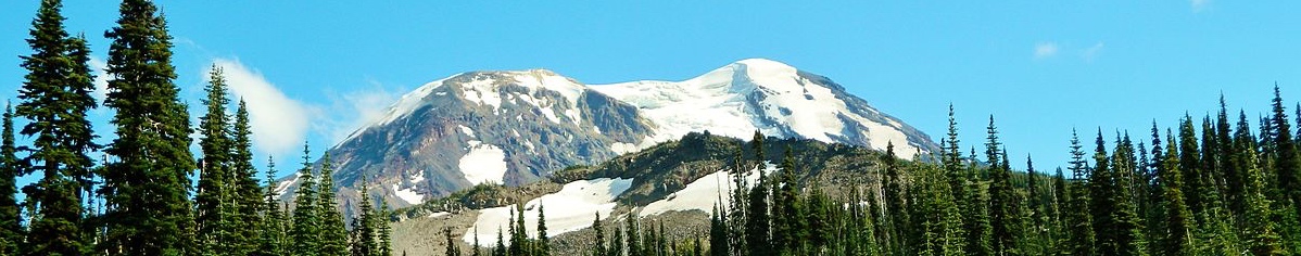
Mount Adams (3,742m/ 12,276 ft) is an almost picture perfect mountain – even if its top seems to been mislaid. It stands as the second largest mountain in the Cascade Range of America’s Pacific Northwest, encircled by Mount Rainier, Mount Hood and Mount St Helens.
Jump to Climbing and Hiking Guide.
Its isolated appearance, similar to those other nearby volcanoes, thrusts this snowy peak far above the lush, green and diverse landscape that wraps around and up from its wide base. Its asymmetric and wide summit plateau, and steep but non-technical ascent routes, make it an inviting prospect for many hikers.
HISTORY OF MOUNT ADAMS.
Another name for Mount Adams is Pahto, meaning ‘high up’ or ‘high sloping mountain’. It is the name given to it in various Native American myths. Paddo and Klickitat (also the name of a local tribe) are other names given in Native American histories, with the latter translating as ‘beyond’.
Mount Adams received its official name in 1853, though it came via some confusion.
Named after President John Adams, this name was originally destined for Mount Hood (3,429 m/ 11,249 ft) . But it appears that the location of Mount Hood was (deliberately or accidentally) plotted incorrectly on the map, designating a peak north of the Columbia river. As it happens, this was exactly where Mount Adams stood and the error was never righted!
The Yakama (or Yakima) Nation was formed in 1855, when the first Chief signed an accord with the white settlers (though a war followed for the next three years within the groups of the tribe). Chief Yah-pa-shah (‘Sharp Shooter’) thus did what few other Native American tribes did – he retained, or regained, Native American land rights in the eyes of the white settlers.
The Yakama Nation covers an area from the Cascade Range in the west to Route 82 in the east. This is a federally-recognised Native American Reservation, and is home to around 32,000 people belonging to seven different tribes.
In various Native American myths, Mount Adams (Pahto) is related to nearby mountains Mount Hood (Wy’east), Mount Rainier and Mount St Helens (Loowitlatkla). Variations on the myth surround different battling love affair scenarios.
One of the more entertaining myths comes from the Cowlitz tribes:
Mount Rainier had an argument with Mount St Helens and Mount Adams, who were his two wives. Whatever the argument was about made Mount St Helens terribly jealous and she erupted, knocking the head of Mount Rainier in the process!
The logic for this narrative is clearly found in the geography: Mount St Helens is an active volcano (last erupting in 1980) and Mount Rainier does seem to be missing a chunk of its summit!
However, the flat top of Pahto can be explained through another myth:
When the beauty chose Pahto over Wy’east, the latter brother struck Pahto on his head, leaving him square and squat. In yet another myth, Pahto is said to be simply hanging his head in grief after his lover died.
GEOGRAPHY OF MOUNT ADAMS.
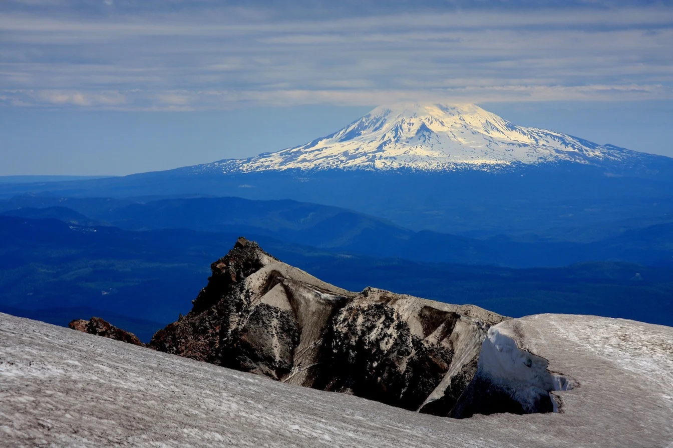
Located 52 km (32 miles) north of the Columbia river, 54 km (33.5 miles) east of Mount St Helens and 74 km (46 miles) south south east of Mount Rainier, Mount Adams sits at the centre of some stunning landscape. Its nearest major city is Portland, the centre of which lies 120 km (74.5 miles) to the mountain peak’s south-west.
These explosive neighbours are worth mentioning further.
Mount Rainier (4,392 m/ 14,411 ft) and Mount St Helens (2,549 m/ 8,363 ft) are both active volcanoes, in the northern section of the west coast Cascade Range. This is less a clear range and more an arc of volcanoes, often separated by some distance.
They are also part of the larger ring of fire, a stretch of volcanoes that encircle the Pacific Ocean. They run along the rim of the Pacific tectonic plate, where it meets other plates with dramatic consequences! Around 75% of the world’s active and dormant volcanoes lie within this ring.
Mount Adams is also still considered an active volcano, even though its last eruption was over 1,000 years ago. It is ice capped and has a towering prominence of 2,474 m (8,116 ft, 37th in North America), dominating the surrounding landscape. Clouds wrap its square peak, which even in the summer is covered in the white streaks of its permanent snowpack.
Its summit is asymmetrical and, from some views, the peak appears almost like a cube. Its unusual shape and flat surface is the result of cone-building eruptions through separate vents. This also leads to prominent, square ridges down much of the mountain’s slopes, including the aptly named North Cleaver which drops from the top of the North Face.
It began building around 520,000 years ago through multiple eruptions, creating a footprint with a diameter of 29 km (18 miles). It is the second largest volcano in the Cascade range (by volume), with the largest being Mount Shasta (4,322 m/ 14,179 ft).
Its wide flat summit slopes gently to its true summit on the northern rim. It has a false summit 800 m (2,625 ft) away to the south, which is known as Pikers Peak (3,553 m/ 11,657 ft).
Its geography is divided between the Mount Adams Wilderness area (upper and western sections) and the Yakima Nation (eastern flank). It sits over the Cascade Crest, in line with similar Cascade volcanoes in Oregon and further south, but further east than the others found in Washington.
While the mountain is covered with only 24 km2 (9.3 sq miles) of glaciers today, nearly 90% it was covered by ice in the past. The western slopes tend to be the most consistently glaciated, while the east slopes show the effects of previous glaciation with deeply-carved and ominously-named canyons: Hellroaring canyon and Avalanche valley.
The largest group of glaciers begin on the summit ice cap. They encircle the mountain: Adams (north-west), Klickitat (south-east), Lyman (north-east) and White Salmon (south-west)
These four are lined by a number of other lesser glaciers, with 12 glaciers during down Mount Adams slopes in total. The level of the glaciers has remained relatively constant for the past 60 years, breaking the pattern of retreat seen on so many mountains around the world.
Two major rivers and two other significant river systems begin on these slopes. The Lewis river (153 km/ 95 miles long) and the White Salmon river (71 km / 44 mile) flow from the glaciers, and both are tributaries of the Columbia river, found to the south. The Cispus and Klickitat river systems originate in the many glacial streams too.
WILDLIFE OF MOUNT ADAMS.
Flora
Mount Adams, and the surrounding recreation area, is a fantastic example of the flora found across the Pacific Northwest. With a more diverse environment than found around many of its neighbours, this mountain supports 843 species that live above 1,220 m (4,000 ft) alone.
This abundance is supported in large part by the expansive meadows that dominate the mid-level of the mountain. The Bird Creek Meadows, a series of alcoves that stretch all along the southern rim, are some of the best known, while the Wetland Grand and other swamp meadows support different kinds of plant life.
Some of the more fascinatingly named plants found in these meadows include: monkeyflowers, magenta paintbrush, bog blueberry and the ever-so-elegant, flatleaf badderwort!
Higher up, the subalpine meadows are smaller. These are found in the highest concentration on the colder north and west sides of the mountain.
In terms of trees, the progression of the coniferous forest is typical of the region.
Lower elevations contain ponderosa pine and douglas firs; at mid-elevations lodgepole pine and silver firs take over; and at subalpine levels, mountain hemlock and whitebark pine predominate. There are 18 species of trees in total found on Mount Adams.
Recent changes to the forest structure have been attributed to global warming. This has led to meadows decreasing in size as the trees take over more of the space, while the tree populations are suffering from epidemics of pests. Logging on the lower slopes has also impacted the wildlife, ‘for better or for worse’.
Fauna
Again, Mount Adams is a prime example of the fauna found in the mountainous regions of the Pacific Northwest.
Rocky Mountain elk, deer, black bears and coyotes are all common to many of these areas. Bobcats, who are from the lynx family, also live in the forested areas of Mount Adams. The most common wildcat in North America, its common name describes its squat tail.
Also found on these slopes is the majestic cougar. Like a house cat but realised on a far grander scale, these sleek creatures are sometimes referred to as pumas or mountain lions. They are North America’s second largest feline.
However, their prey are largely on the decline. Pika and marmot numbers have decreased substantially in recent years, reflecting their shared sensitivity to even subtle temperature changes. Douglas squirrels (found higher up) and the Cascade golden-mantelet ground squirrel are still doing well, though if predation on them increases, another population bottleneck may not be far away.
Up above, crows, raven, Stellar’s jays, Clarks nutcracker and Canada jays can be spotted, along with predators like the peregrine falcon and sharp-shinned hawk. Various species of grouse can also be found in the meadows and higher up the mountain, though the white-tailed ptarmigan seem to have left the area.
FIRST ASCENT OF MOUNT ADAMS.
Mount Adams was first climbed in the fervent era of railroad and road building, which began connecting the vast space of the US. As such, the first summiteers were not mountain men but railroad workers, who happened to be camped to the mountain’s north-east.
They were building a military road from the Columbia river in the south to Puget Sound in the north-west, passing through Naches Pass (east of Mount Rainier).
These men were A G Aiken, Edward J Allen and Andrew J Burge. Little else is known about their feat, with the facts of this account being known only through a book written by George Himes in 1907.
It is likely they followed the North Cleaver route (see below), given where their camp is thought to have been set.
CLIMBING GUIDE FOR MOUNT ADAMS.
There are many routes up to Mount Adams' summit. In total 26-30 routes are listed, and these vary from class 2 hikes to Grade IV climbs.
However, there are other headwall routes that have been climbed once and once only. As these are susceptible to rockfalls, either a section of the route has been destroyed while climbing or the climbers simply marked it as unviable.
Given the mountain’s height, weather is always a factor, with the potential for treacherous weather, sudden storms and variable temperatures present throughout the year.
Despite this, Mount Adams has a relatively long climbing season. It stretches from the ice and snow climbing of spring (March-May) to the peak climbing season of May-October.
The most popular route is the South Spur route. This is recommended as a two-day hike, with an overnight at the Lunch Counter 2,865 m (9,400 ft).
Also known as the South Climb, South Side or South Rib route, this is thought the easiest and most direct ascent of the mountain. It navigates a path from directly south of the peak, and although there are a lot of switchbacks, its path doesn’t meander from its lofty goal very much.
It is only 10 km (6.2 miles) from the trailhead to the summit, but the elevation gained in this distance is 2,035 m (6,676 ft). As such, while not technically difficult, it is a trail recommended for experienced hikers, comfortable with ice axes and crampons over ice and snow.
From the Cold Springs Campground 1,707 m (5,600 ft), take the trailhead up the switchbacks before following the old road track. The first landmark is the Round-The-Mountain-South trail junction, also the site of an old campground.
You’ll be heading straight up into the Mount Adams Wilderness area from here. Follow the trail as it steadily steepens. First you pass creeks before heading up around the Crescent glacier via the numerous switchbacks that run alongside it. After gaining the snowfield above the glacier, you’ll soon reach the plateau of the Lunch Counter.
There is a choice of two routes from here: head straight up the snow, or scramble around on the rocky surface to gain the Suksdorf Ridge. The ridge leads you to the false summit of Pikers Peak (3,553 m/ 11,657 ft), or you can traverse around it via its southern slope.
Drop down into the saddle next before the steep final ascent to the true summit. This is first identified by the old lookout building perched near the edge.
Descent normally follows the same route, with the goal of completing the return in two days usually very manageable.
Of the other routes available, the North Ridge or North Cleaver isanother popular class 2 hike. It departs from Killeen Creek, where many other climbing routes begin. Bird Creek, also home to some of the more impressive meadows, hosts a good number of the climbing challenges too.
INFORMATION ON HIKING AROUND MOUNT ADAMS.
The protected wilderness area around Mount Adams is criss-crossed with hiking routes, so even if the summit doesn’t tempt you, surely some of these adventures will!
The Mount Adams Wilderness area offers routes through the surrounding areas as well as around the mountain. Trail #9 is known as the Round-The-Mountain trail and, predictably, it’s a circuit loop of the peak.
Stretching 13.5 km (8.3 miles) through undulating terrain, it connects the Pacific Crest Trail with the Yakama Indian Reservation Tract D. A permit is required for these eastern sections of the walk through the reservation. It is obtainable from the rangers at Bird Lake.
The Pacific Crest trail stretches 4,265 km (2,650 miles) along the whole west coast of the United States. It connects Mexico to Canada via California, Oregon and Washington.
It passes to the west of Mount Adams, and it is common for individuals to cherry-pick day or multi-day sections from this long trail. These could lead you north or south to some of the other stunning mountains found in the area.
But this is also a mountain that supports a faster descent!
In winter, though with conditions actually best during the spring, ski descents are popular along the south-west slopes of Mount Adams. Known as the South-west Chutes, the typical route taken zig-zags down the mountain, cutting west and south to avoid the rocky sections found in certain places.
It certainly beats a long downhill walk.