

Up and down North America, some of the world’s great long distance hikes challenge hikers to walk the length and breadth of the continent.
From circuits around stunning natural features, to full traverses of the USA, below we have gathered five of the best shoe-breaking, awe-inspiring trails to get you planning an all-American (and Canadian!) adventure.
So, whether you want to be a day, section or thru-hiker (walking the whole length of the epic trails) read on.
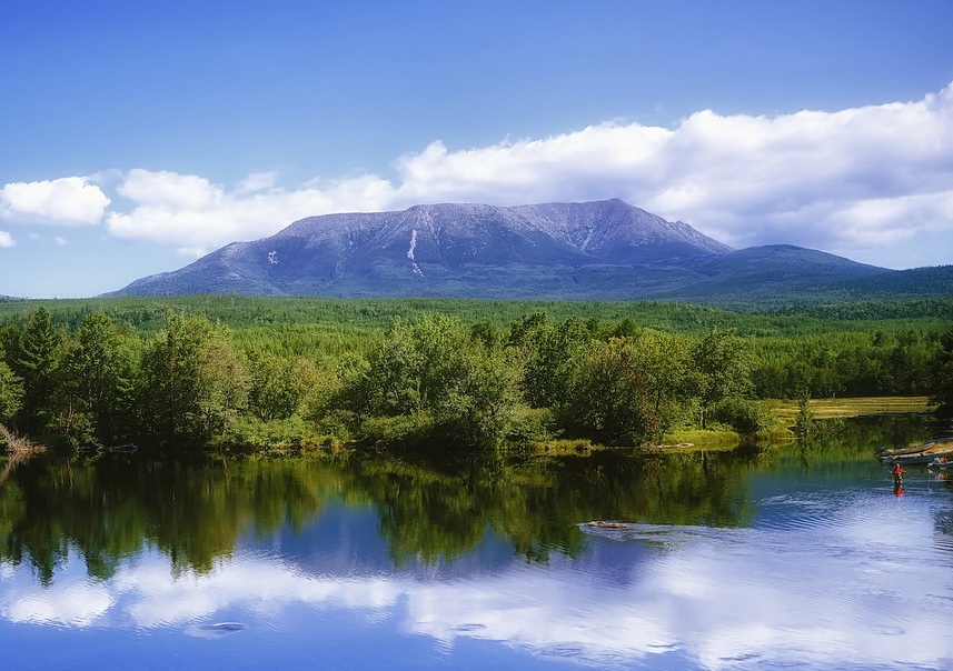
Appalachian Trail
From/to: Springer Mountain (Georgia) to Mount Katahdin (Maine)
Distance: 3,525 km (2,190 miles)
Walk time: 165 days (around six months)
When to walk: March-September
Short description: The world’s longest trail exclusively for hiking is a six-month epic adventure, completed by only a fraction of those who attempt it. But as long-distance hiking pilgrimages go, this sits near the top of the list.
Passing through fourteen US States, the epic Appalachian Trail (AT) is visited by more than 3 million visitors annually. Unsurprisingly, few attempt the whole distance, with most following the white dashes through day-hikes and sections.
The AT was first proposed as an antidote to city life by Benton MacKaye in 1921. A former forester, he obviously found himself yearning for the outdoors again from his desk as a newspaper editor. The AT design was not completed until 1937, with maps, trail markings and routes cut by newly formed voluntary trail clubs.
This hiking trail was also the inspiration for the Pennine Way in northern England.
It reaches south-north from Springer Mountain in Chattahoochee National Forest in Georgia to Mount Katahdin in Baxter State Park in Maine. Much of the AT is accessible within a two-hour drive of a population centre.
Generally hanging to the southern and eastern side of the Appalachian Mountains, the AT is divided into four separate sections (south-north): the Southern Mountains, the Virginia Highlands, the Mid-Atlantic Lowlands and New England.
Notable sections include: Clingmans Dome (2,025 m/ 6,643 ft), the AT’s highest point; Bear Mountain State Park, NY (38 m/ 124 ft), the AT’s lowest point; and a famous convenience store located halfway, where the AT tradition is for hikers to eat half a gallon of ice cream!
While thousands attempt the whole trail each year, only 1 in 4 succeed in becoming a true ‘thru-hiker’. Typically the AT is walked south-north from March/April to September. The toughest part is the northern section, so far fewer hikers complete the route north-south, probably discouraged by this difficult start.
If you do succeed to walk the whole of the AT, you’ll experience 141,580 m (464,500 ft) of elevation changes—that’s 16 Mount Everests. Want more motivation? Watch National Geographic’s documentary about the AT thru-hike.

Pacific Crest Trail
From/to: Campo (US border with Mexico) to Manning Park, Canada.
Distance: 4,265 km (2,650 miles)
Walk time: Five months
When to walk: Late April-September
Short description: Travelling between deserts and forest, volcanoes and glaciated mountain slopes, the Pacific Crest Trail takes you through the US west coast’s varied landscape, from Mexico all the way to Canada.
Walked in either direction, the Pacific Crest Trail (PCT) takes an average of five months to walk.
You will walk the entire length of the USA in completing the PCT. This well-marked path takes in the deserts of the south, the mountains of California, Oregon and Washington States and much of the volcanic arc of the Cascades.
Heading northbound is the more popular direction, with 90% of thru-hikers beginning in the south. The southbound route offers great solitude, but this direction misses the short Canadian section. ‘Southbounders’ have to start from Harts Pass in the USA, as it’s illegal to pass the Canadian border via the PCT!
A late April start either way allows you to avoid problematic weather, particularly the risk of mountain snow at either end. En route, you pass close enough to Mount Whitney and Mount Rainier to warrant taking a day out and visiting these magnificent summits.
While most PCT hikers are day or section hikers, 4,661people have made it as true thru-hikers. In the last few years (2014-2016), an average of 542 hikers have achieved this. The first to walk the whole length were June and Don Mulford, back in 1959; it was 1970 before anyone else did.
From Mexico to Canada, here’s what you’ll pass on the PCT:
• Southern California – Campo to Walker Pass – Beginning next to Mexican border, this route takes you through the San Jacinto Mountains, San Bernadino and San Gabriel ranges to the Tehachapi Mountains, ending at the southern end of the Sierra Nevada. Skirting the western edge of the Mojave desert and with views of the LA basin, much of this section’s hiking is in shrubland and forest.
• Central California – Walker Pass to Interstate 80 – Never dipping below its start height (1,599 m/ 5,246 ft) at Walker Pass, this route follows the meadow, forest and mountain landscape of the Sierra Nevada, Sequoia and Yosemite National Parks. Near Mount Whitney (4,421 m/ 14,505 ft), the John Muir Trail joins the PCT at one of its most undulating sections. From deep canyons to the PCT’s high point (Forester Pass, 4,009 m/ 13,153 ft), this is an epic section of the adventure.
• Northern California – Interstate 80 to Siskiyou Summit (1,314 m/ 4,310 ft) – As the Sierra Nevada falls behind you at the north fork of the Feather river, you meet the southern end of the volcanoes of the Cascade range. This winding, indirect route through travels through lush forests fed by rich volcanic soil, wide rivers and an abundance of wildlife, except for a central section that passes by the dry Hat Creek Rim and Mount Shasta (4,322 m/ 14,179 ft).
• Oregon – Siskiyou Summit to Bridge of the Gods (55 m/ 180 ft) – The easiest and shortest section of the PCT. The principal attractions are the mountains of the Cascade range, including the magnificent Mount Hood (3,429 m/ 11,249 ft), as well as the lakes that border the trail.
• Washington – Bridge of the Gods to Manning Park – Beginning in the lowlands of the Columbia river gorge, this final stretch circuits around Mount Adams and Mount Rainier (4,392 m/ 14,411 ft). Strongly undulating through the rugged northern Cascades, exposed sections of private land can make this a challenging finish to a long adventure. The beauty of the early autumn colours help maintain motivation all the way to the end in Canada.
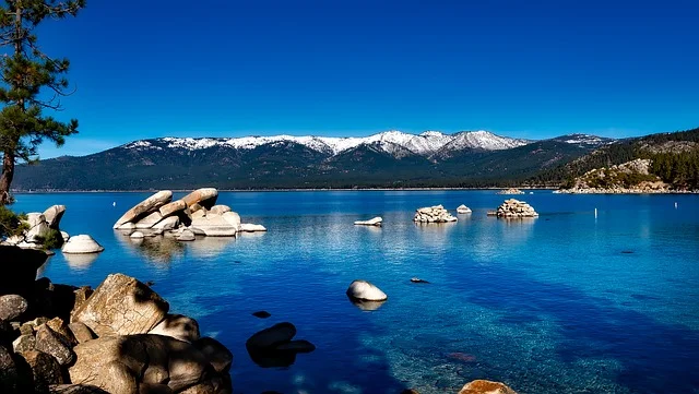
Tahoe Rim Trail
From/to: Various starting points.
Distance: 266 km (165 miles)
Walk time: 10-15 days
When to walk: July-September (open year-round)
Short description: Circling the Lake Tahoe basin through the Sierra Nevada and Carson ranges, this multi-use trail may find you walking alongside horses and mountain bikers on one the country’s most accessible thru-hikes.
Glacial-carved valleys, lush meadows and volcanic formations are mere support acts to the Tahoe Rim Trail’s main attraction—its beautiful alpine lakes.
Despite being shorter than our other epic American walks, this route offers enough variation to challenge the most experienced of thru-hikers. It is often used as a way to test oneself before taking on one of the multi-month hikes, and requires careful planning for food resupply, finding fresh drinking water (ironically!) and getting to the best camping spots. It also tests your gear with downpours thoroughly soaking any ill-prepared adventurer.
The highlight of the journey has to be the walk around the 35 km (22-mile) long 19 km (12-mile) wide Lake Tahoe. The second deepest lake in the USA (501 m/ 1,645 ft in Crystal Bay) beautifully clear, with visibility down 22 m (73 ft). Seen from the ridge line above, it is an idyllic sight.
The eight sections that make up this trail undulate through the terrain, with elevation changes of around 7,400 m (24,278 ft) over the course of the whole trek. Each section, reachable by road, can be taken independently, with most being day-hikes or two-day adventures.
The trail was completed in 2001, but discrete sections have been walked since the early 90s.
Highlights include: the summit of Mount Rose (3,287 m/ 10,785 ft); the views of the lake from Spooner Summit (2,179 m/ 7,150 ft); and the wildflowers of Page Meadows, close to Tahoe City.
The eastern stretches head through Nevada, while the southern and western sections are in California. While most is forested, the north-westerly section is different. Known Desolation Wilderness, its rocky, barren terrain offers up waterfalls, rivers and sparse vistas, making this a totally different experience to the rest of the trail.
Arizona Trail
From/to: Coronado National Memorial (border with Mexico) to Coyote Valley (border with Utah)
Distance: 1,287 km (800 miles)
Walk time: 85-128 days (12 weeks-4 months)
When to walk: April-October
Short description: Walking the length of Arizona, this trail takes you between sky islands, through lowland desert and forest, and on to the world’s most famous canyon.
Newer than other trails listed here, the Arizona Trail (AT) is a National Scenic Trail that was only completed in 2011. It traverses the whole of Arizona from the border with Mexico in the south to the border with Utah in the north.
Over the course of the AT, a landscape of deserts, mountains, plains and canyons lies either side of your path. The sky islands are striking and unusual features rising up from contrasting landscapes. Mount Lemmon is a prime example: barren desert turns to lush vegetation as you climb its slopes.
Another feature of the AT is the wildlife. Grazing cattle herds, mountain lions, burrowing bees and bark scorpions may cross your path, as these AT thru-hikers describe.
Typically walked south-north (though it can be walked in either direction), the trail moves through a number of mountain ranges, including:
• Huachuca Mountains
• Santa Rita Mountains
• Rincon Mountains
• Santa Catalina Mountains
• San Francisco Peaks
In this final range, the trail reaches its high point of 2,900 m (9,514 ft), while it is lowest (520 m/ 1,706 ft) at the start of the central section around the Gila river, which crosses Arizona east to west.
In the southern sections are well known peaks such as Mount Lemmon (2,795 m/ 9,171 ft) and the square ‘Superstitions’, a range of block-like mountains east of Phoenix.
In the northern sections, from the town of Flagstaff on, are Arizona’s highest peaks. Humphrey’s Peak (3,851 m/ 12,637 ft) lies just to east of the path, along with the other towering giants of the San Francisco Peaks.
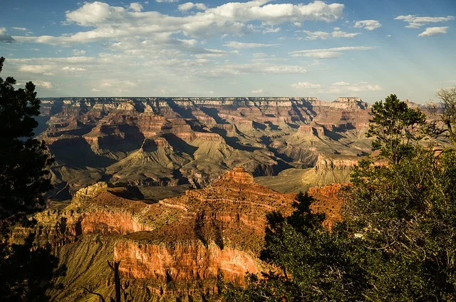
Beyond this is the other great highlight of the trail: the Grand Canyon.
Descending the South Rim via switchbacks, you cross the Colorado river by a suspension bridge before climbing back up to the North Kaibab trailhead and the North Rim. After the pine forests of the central sections of the AT, this is a breathtaking experience, walking through a famous natural landmark.
There are numerous communities, towns and places to touch base with civilisation and restock along the trail. There’s also an app, ‘Arizona Trail’, so you’ll always have the latest weather and trail information close at hand.
The AT is divided into 43 sections that vary from 13.4 km (8.3 miles) to 58 km (36 miles). These offer good day and multi-day options along the length of the AT. The trail is multi-use, so you may also come across runners, horses and mountain bikers.
A typical thru-hike takes between three to four months. The fastest hikers have completed it in under 29 days. Taking your time to smell the wildflowers and take in the views is probably worth arriving a little later than these speed merchants.
The AT is best walked between late spring and mid-autumn.
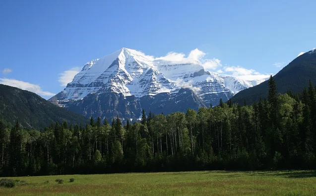
Mount Robson
Great Divide Trail
From/to: Watertown Lakes National Park (south) Kakwa Provincial Park (north)
Distance: 1,200 km (746 miles)
Walk time: 8 weeks
When to walk: July-September
Short description: Travelling north from the US/Canada border, the Great Divide Trail heads straight up the middle of Rockies and into some of Canada’s most famous, epic and challenging landscapes.
On the Great Divide Trail website, it is described as ‘one of the most spectacular and challenging long-distance trails on the planet’. With its epic setting of the Rocky Mountains and long sections of unmarked wilderness, it would be hard to argue with them.
The Great Divide is a fault that runs the length of North America. This trail joins it as it crosses from Montana, USA into Canada. The Great Divide Trail (GDT) passes through five National Parks, seven Provincial Parks, four wilderness areas and five forest districts. So, if you want to get into the Canadian wilderness, this may be just the adventure for you.
Walking through the Canadian Rockies, and criss-crossing the Great Divide between the provinces of Alberta and British Columbia, this trail is strenuous. A physical challenge to the most experienced long-distance hiker, it also requires navigational know-how to avoid the potential hazards found along GDT.
Among these challenges are crossings of glacial streams, summer snowstorms, difficult navigations in the mountains, the general remoteness of the trail, and (oh yes) grizzly bears.
But the rewards more than make it worth the hard work. Snow-capped peaks, shimmering glacial water, panoramic views and lush, diverse wildlife among the Rocky Mountains all greet GDT hikers.
If you have a good tolerance for cold water, you can even refresh yourself en route with a dip in one of the glacial-fed lakes en route.
This GDT was first proposed in 1966, by the Girl Guides of Canada. After a couple of decades of almost and nearly actions, the still undeveloped, unofficial trail, looked doomed to disappear.
But a new guidebook, released in 2000, reignited the GDT and has given it a present and, hopefully, a future. It remains unofficial (according to Parks Canada) but is now enthusiastically maintained and supported by volunteers.
Without official accreditation and funding, it still isn’t as clearly cut as some of our other long-distance hikes. As 40% of the trail sits outside of the Rocky Mountain Parks system it is ften unmarked, and sometimes not even really a trail. So this is our true wilderness entry, not to be attempted without some thorough planning and map-reading practice !
It is a narrow window in which to complete the whole trail. Snow is common underfoot into July, and as it is typically walked south-north, finishing before the autumn weather turns is vital.
All this leads to some sense of who thru-hikes, and who just cherry picks some of the choice day-hikes. Around 20 people complete the journey each year, averaging eight weeks through high summer, while hundreds will walk sections during the season.
One other note for thru-hikers is about camping: when in a park, you must use a designated campground. So, plan your sections ahead to make sure you can get between suitable places in daylight hours.

LATEST BLOG POSTS
I quit the rat-race to live a more adventurous life. This is my journey.