
Photo by Jonwmcinenrey
Mount Monadnock exudes an American pride in the this idyllic north-eastern corner of the US. The mountain is the eponymous star of a book and a film called: “Monadnock: The Mountain that Stands Alone” (2007).
Name: Mount Monadnock
Other Names: Monadnock Mountain (official); Grand Monadnock (various); Monadnoc (Ralph Waldo Emerson).
Height: 965 m (3,165 ft)
Location: Jaffrey and Dublin, New Hampshire, USA.
First Climbed: 1725 by Captain Samuel Willard and 14 other rangers.
Climb Time: 3-7 hours
Best Time to Climb: May-June and September-November. Year-round hiking possible.
INTRODUCTION TO MOUNT MONADNOCK.
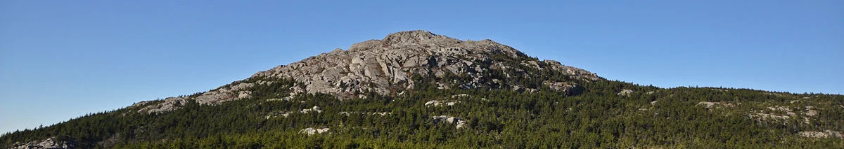
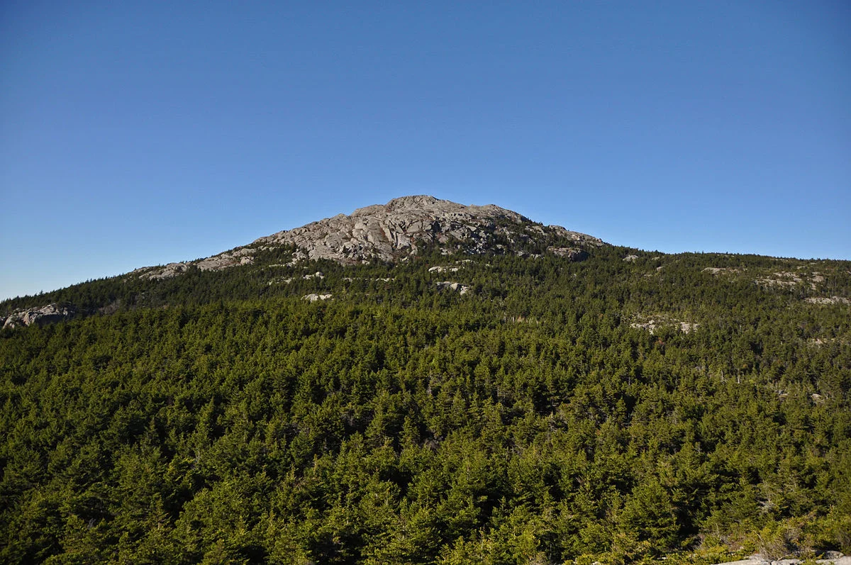
Self-proclaimed as America’s favourite mountain, Mount Monadnock (965 m/ 3,165 ft) is surely never left lonely for too long – even if it is a mountain that stands alone! After all, it is said to be the most climbed mountain in North America and the third most climbed in the world.
With its artificial tree line, numerous trails and interesting histories in hiking, the arts and recreation dating back to the 18th Century, there is plenty of interest on this low-lying peak.
HISTORY OF MOUNT MONADNOCK.
Monadnock means ‘mountain that stands alone’ in the local language. It was a term adopted in the late 19th Century by American geologists as an alternative term for an isolated mountain. The nearest, comparable or higher peak to Mount Monadnock is 48 km (30 miles) away, so it certainly warrants its name.
Another translation of Mount Monadnock is ‘the bare or smooth mountain’, no doubt reflecting its bare upper slopes.
The local people are the Abenaki tribe of Native Americans. They reside across the north-eastern region of the US and into Canada. They call New England Wabanahkik, meaning ‘Dawn Land’; their name Abenaki is thus a reference to them as ‘people of the dawn land’.
They are made up of several groups of Native Americans who share the Algonquian language, and stretch from here up to Québec in Canada. Their customs mean they never claim to own any land, only using it according to the needs of the seasons, rituals and social needs. This approach left them susceptible to domination by the incoming white settlers in the 18th and 19th Century.
Yet, as a culture, they have managed to retain much of their language and customs, even in the face of this domination, population decline and the division of the lands they traditionally used. This is in contrast with other Native American tribes, such as the Tongva who live(d) near Mount Baldy in California.
Mount Monadnock was afforded US National Natural Landmark status in 1987. This recognises its importance as a prime example of particular biological and geological features. It is one of eleven such designations in New Hampshire, including North America’s largest glacial erratic (a rock that was carried by glacial action far from its source), Madison Boulder.
Two prominent American writers of the 19th Century, Henry David Thoreau and Ralph Waldo Emerson, regularly visited the mountain. Both men used trips out into nature to find the solace and inspiration to describe their wilder, simpler alternatives to America’s fledgling identity. Thoreau is also believed to have completed one of the first naturalist inventories of Mount Monadnock.
A lookout near the summit is named after each of these writers. The symbolism of this isn’t missed; views from the mountaintop clearly so important, to them and us since, to understanding the perspectives their words constructed.
As in the old poetic fame
The gods are blind and lame,
And the simular despite
Betrays the more abounding might,
So call not waste that barren cone
Above the floral zone
‘Monadnoc’ by Ralph Waldo Emerson
Some 60 poems, as well as numerous paintings and musical compositions, have been created about the mountain, no doubt inspired by the undeveloped state of the surrounding nature. These come from famous and infamous authors alike, including H P Lovecraft, Amy Lowell and James Pelletier, whose poem ‘Monadnock’ was an important comment made shortly after 9/11.
GEOGRAPHY OF MOUNT MONADNOCK.
The ‘mountain that stands alone’ has a prominence over two thirds of its full height: 660 m (2,150 ft). This causes it to utterly dominate the local landscape. Come winter, the summit has some snow cover, though not nearly enough to remain once the weather starts to heat up by May. Mount Monadnock stands at 965 m (3,165 ft) high, although a sign at its summit declares that it’s a foot taller (the sign is wrong)!
It was formed as a fold nappe. This is where a plate becomes compressed and, rather than giving way at its edge, the crust bulges and folds elsewhere. In this case it has caused an overturned syncline, so instead of the compression creating a valley, it has bulged up and created a mountain.
To understand how this works, place a piece of paper on a table and hold two opposite sides. Slowly move these edges in towards the centre and watch one or two folds bulge up in the middle. This is a simple image of the action that created Mount Monadnock.
Numerous smaller folds, further evidence of this action, can be seen along the faces of the mountain. The schist and quartz rock that Mount Monadnock is formed of dates back around 400 million years.
Three other local peaks share the mountain’s name. Pack Monadnock (700m/ 2,290 ft) and North Pack Monadnock (694m/ 2,276 ft) are 18 km (11 miles) east in the Wapack Range. Little Monadnock Mountain (579 m/ 1,900 ft) is 11 km (7 miles) south-west. Pack is the Native American word for ‘little’. It seems there are a lot of lonely mountains around this region, perhaps they should become acquainted!
On the summit are relics of numerous structures that have stood here in the past. Iron rings reflect the footprints of temporary structures, while a large rectangular hole carved into the summit is the most notable, and curious, construction. Used by hikers now as a helpful wind break, its origin pre-dates a survey of 1861, though no record of its original function has been unearthed.
WILDLIFE OF MOUNT MONADNOCK.
Flora.
Located within Monadnock State Park, the mountain has an artificial tree line, located around 90 m (300 ft) from the summit. This is actually far below the natural tree line in the region. It is the result of fires in the early 19th Century that destroyed much of the soil cover around the summit.
The scattering of trees that occurs the higher you climb is caused by a incrementally decreasing soil depth. While this opens up the excellent views for hikers, it does limit the vegetative diversity on the slopes.
There are three main vegetation zones. At lower elevations, a mixed hardwood forest greets many of the trails. This moves into a spruce forest which changes to a bush-ledge zone near the summit.
The hardwood forest consists of oak, beech and birch, while on the northern slopes some maple species are also found. Pine, hemlock and the occasional balsam tree can be seen along specific trails, such as the Pumpelly trail.
Above the tree line, alpine wildflowers are an unusual presence given the low elevation. They grow partly because of the degree of exposure, as well as the thin spoil in which they thrive better than others. The wildflowers include the tiny white flower clusters of mountain sandwort, alpine goldenrod and the three-toothed cinquefoil. You might even see some mountain cranberries poking out of cracks in the rocks!
Fauna.
As the elevations experienced on this mountain are relatively low, the fauna found on the slopes is typical of central New England, rather than having a specific mountain ecology.
Moose, deer, turkey, fisher cat, porcupine and the red fox are common inhabitants. In winter, the snowshoe hare becomes harder to spot as its white coat blends seamlessly into the background. Black bears do inhabit the mountain and surrounding areas, though interactions with hikers are very rare. Coyotes are also found in the area, though spotting one is certainly not an easy task.
Up above, ravens, turkey vultures, blue jays and black-capped chickadees can be seen.
The turkey vulture is the most widespread vulture found in the Americas, reaching from here all the way to the Caribbean. They are not killers but scavengers, preferring to arrive at recent kills to eat their fill.
This probably how Captain Willard celebrated.
FIRST ASCENT OF MOUNT MONADNOCK.
The first noted ascent occurred in 1725, by Captain Samuel Willard and fourteen fellow rangers. They camped at the summit to keep watch for Native Americans. Little else is known about this ascent, and it seems not to have been more work duty than great adventure.
Many early summiteers are also known to us, as they carved their names into the summit. This was a practice that reflects the conquering pioneer attitude, marking the permanent landscape with personal, momentary achievements. Thankfully this was later discouraged, yet marks from the late 18th and early 19th Century are still clearly visible on the summit.
HISTORY OF MOUNT MONADNOCK’S TRAILS.
The mountain’s status as the third most climbed in the world is debatable. Some local press currently places it as the most climbed mountain in the world, while several other mountains also put themselves in second place behind Mount Fuji (3,766 m/ 12,356 ft).
But neither of these peaks comes close to Tai Shan, China (1,533 m/ 5,030 ft). This peak is reported to be climbed by over 2 million visitors per year, with a reported 6 million visiting in 2015.
For the sake of argument, let’s just say Mount Monadnock is climbed a lot – a sign that solitude is not one of the virtues to be discovered here!
Many of the trails climb the south-west of mountain, and these are relics of trails cut and named by guests of the Halfway House hotel.
This hotel stood on western slopes from 1858 until it burned down in 1954. The trails to and from the hotel were so well-defined that the authorities have continued to maintain them. There is also a requirement that no further trails are cut, and so the northern flanks have far fewer trails.
A series of trails on the mountain that carry the name Smith. These are named after a local industrialist, Scott A Smith, who founded the Monadnock Mountain Association and helped cut many of the trails around the Halfway House.
GUIDE TO HIKING MOUNT MONADNOCK.
While the peak can be hiked year-round, be aware that snowfall in the winter (December-March) and summer thunderstorms can be hazardous on these exposed slopes. Dehydration and heat stroke are the main threats to hiker’s health in the summer.
The best time of year to climb is in spring and autumn, May-June and September-November respectively.
There are numerous routes that climb directly to the summit of Mount Monadnock. Most of the 56 km (35 miles) of trails line the south-west side (see above), with the patchy distribution of trees offering relatively consistent views for much of the route.
The longest direct route is Pumpelly trail at 7.2 km (4.5 miles), while the shortest is the White Dot trail 3.1 km (1.9 miles). None are technically challenging, but some boast a few steep and strenuous sections.
The shortest and most direct route up the mountain, this is the most popular trail. It is marked by painted white dots along the path.
From Monadnock State Park headquarters, follow the well worn path between pines, hardwoods and spruce. At the White Cross trail junction continue straight to arrive at the Cascade Link (1.3 km/ 0.8 miles). The path becomes more exposed and steeper, reaching the Old Ski Trail after 1.9 km (1.2 miles).
Continuing through patches of hardwood and spruce, with a great view of the summit offered on the flat section called the Plateau, the route rejoins the White Cross trail 0.5 km (0.3 miles) from the summit.
Descent usually follows the same route back down.
• White Cross trail
A variation on the above trail, this one offers some steeper hiking through younger forest. It adds on around 200 m (650 ft) in distance to the above route.
The junction at 1 km (0.6 miles) is where the trail detours from the White Dot trail. Heading into young birch forest, this trail follows an area burned in 1953 and, remarkably, it is still recovering.
There are two steep sections: one immediately after leaving the White Dot trail and a second known as the Switchback, whose steps cut into the path to help hikers but certainly help it live up to its name! The grades vary from easy to moderate from here on up, passing the Plateau where you rejoin the White Dot trail.
Views of Bald Rock can be enjoyed across Dingle Dell valley just below the Plateau.
• OId Toll Road / White Arrow trail
A longer, less steep route to the summit than the above trails, there are a number of variations on this route that pass in and around the old Halfway House.
The White Arrow trail is one of the oldest trails on the mountain. It starts at the Halfway House, 1.8 km (1.1 miles) above Route 124. It has been worn away over the years through use to look like it has been carved out by a stream.
From the recently cleared area around The Halfway House, you re-enter the woods and reach a junction where you turn right (it is clearly marked), and another from where the the trail starts to climb. Follow the carved path, being careful in winter that it is often filled with snow, making it unpredictable.
The short final section is over bare rock, offering impressive views from a little before the summit.
• Pumpelly trail
This is a scenic route up the Dublin Ridge, beginning at East Lake road at a trailhead that is not very well marked. It begins on private property, so keep to the marked trail.
An easy first 1.6 km (1 mile) is replaced by switchbacks. The first views arrive around halfway to the summit as you reach the crest of the first crag. Passing through spruce woods, you climb the shoulder of the mountain to reach the Cascade Link junction.
A short, steep section takes you to the great views from Bare Crag, then onto another called Town Line Peak, which can detour you towards this mountain. Instead, head south to the Spellman junction and on uphill to the summit.
This trail crosses several others en route, but is consistently marked with maintained cairns (rock piles) and some painted marks (last refreshed a few years ago)
Some other trails worth considering include:
• Marlboro trail: Difficult road to the trailhead (Shaker Farm road) but offers a ledge halfway to summit with impressive views.
• Dublin trail: From Old Troy road, this is a moderate grade 3.3 km (2.1-mile) trail.
• Red Spot trail: A 5.6 km (3.5-mile) trail with a steep middle section. Joins the Pumpelly trail for the summit section.
No direct route up the mountain should take more than three to seven hours return. The reward for this short hike to the summit is a view stretching some 160 km (100 miles) over parts of all six of New England’s states.
You’ll have to show your canine companions a picture from the summit though; dogs have been banned from the mountain since 1986.