
Photo by Kogo
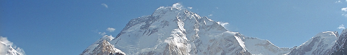
Broad Peak, the world’s 12th highest mountain stands in the company of giants, with their bases snaked around by some of the world’s longest glaciers.
Name: Broad Peak
Height: 8,051 m (26,414 ft)
Location: Part of the Karakoram Range on the Pakistan-China border.
First Climbed: 8 and 9 June 1957 by a four-man Austrian expedition.
Climb Time: 22 days from Base Camp, 7 weeks for whole trip.
Best Time to Climb: June-July
INTRODUCTION TO BROAD PEAK
Broad Peak (8,051 m/ 26,414 ft) stares across to the mighty K2 in one direction, and the imposing Gasherbrum summits in the other.
Below, huge glaciers cross paths at the ‘Throne Room of the Mountain Gods’, while above them, the world’s highest passes offer a sort of safe passage to adventurers.
Jump to Climbing or Trekking Guide
Bordering China and Pakistan, this mountain is typical of the area: high, dangerous but utterly awe-inspiring. Named after a Swiss mountain almost half its height, Broad Peak is part of the greatest sequence of mountains in the world, stretching from the Hindu Kush across to the easternmost point of the Himalayas.
This is an area of genuine superlatives, though each is laced with the toughness required to survive such an extreme environment.
Broad, mighty and challenging, meet Asia’s Broad Peak.
HISTORY OF BROAD PEAK
The name Broad Peak was introduced to the area in 1892 by Martin Conway.
A British explorer, this name is derived from the mountain in Europe, Breithorn (4,165 m/ 13,665 ft) which means ‘broad horn’. This mountain of the Pennine Alps borders Switzerland and Italy. It is a huge triple-headed peak sufficiently broad and isolated to dominate the skyline above the lush European landscape, just like Broad Peak does in Asia’s icy kingdom.
Among the Balti people, the peak is supposedly known as Faichan Kangri. This is a strange bastardisation of the initial translation of Broad Peak into Balti, P’alchan Kangri. Yet, how much this name is actually used is debatable; the Balti language has no f-sounds, no doubt a barrier to pronouncing the name and at least part of the reason for its unpopularity.
This mountain has also been called K3, part of a series of five Karakoram mountains first listed K1-5. Only K2 (8,611 m/ 28,251 ft) has retained this uninspiring name.
Like many such mighty mountains, taking an adventure on these slopes is laced with significant danger.
Deaths have occurred from falls, avalanches, altitude issues and exposure. In total, at least 29 deaths have occurred on these slopes, many simply labelled as a ‘disappearance’. Most have occurred on the West Ridge Route, as this is the route most commonly climbed.
Unlike many Himalayan peaks, but similar to other Karakoram peaks, the death rate on this mountain has increased since 1990 (often given as the watershed moment in mountain climbing popularity). The death rate pre-1990 was 5%, rising to almost 9% since.
Broad Peak’s death rates, comparable to Everest’s, pale in comparison with the world’s deadliest peaks. The death rate on Annapurna (8,091m/ 26,545 ft), is around 27% today, but peaked at 41% back in 2008.
So really, Broad Peak is a pretty safe mountain in this context. Don’t take that as an invitation to take it lightly, however.
GEOGRAPHY OF BROAD PEAK
Broad Peak straddles the Pakistan and China border in a mountainous region where winding glaciers divide peaks like capillaries darting between cells.
In China, to the east, the mountain descends into the Shaksgam Valley, an inhospitable area bound by the Kun Lun Mountains on the opposite side. To the west and south is the Gigit-Baltistan region of Pakistan.
Gasherbrum Mountains
Part of the Gasherbrum group of mountains within the Karakoram Range, this peak is neighbour to two other eight-thousanders: Gasherbrum I and II (8,080 m/ 26,509 ft and 8,035 m/ 26,362 ft respectively). These giant mountains of Asia lie to the south-west, joined by a snaking ridgeline that only descends as low as 6,250 m (20,505 ft).
K2, the world’s second highest peak, lies 9km (5.5 miles) away across the Godwin Austen Glacier to the north-west.
Karakoram Range
The Karakoram Range connects the Hindu Kush with the Himalayan Range, stretching around 500 km (311 miles) across central Asia. It is laced with three of the top five non-polar glaciers in the world: Siachen (76 km/ 47 miles), Biafo (67 km/ 42 miles) and Baltoro (see below).
This range is one of the world’s most geologically active, found at the point where the Indo-Australian and Eurasian plates collide. The former is continuing to push north at a rate of up to 4.5 cm per year, a collision process begun 55 million years ago. As such, many of the mountains of the wider Himalayan region continue to head higher, further extending their rightful place as the world’s tallest range.
Broad Peak’s Many Summits
Broad Peak’s long summit ridge begins in the glaciated valley in north-east (Godwin Austen) and continues south-west to meet the rest of the Gasherbrum group. The mountain has multiple peaks along this summit ridge.
These are, in height order:
• Broad Peak (8,051 m/ 26,414 ft)
• Rocky Summit (8,028 m/ 26,339 ft)
• Broad Peak Central (8,011 m/ 26,283 ft)
• Broad Peak North (7,490 m/ 24,573 ft)
• Kharut Kangri (6,942 m/ 22,776 ft)
A debate has existed for some time about how many true summits exist on the massif. Both Broad Peak and the Central summit could be seen as individual summits, though currently the saddle between them is too high to rank them as separate peaks. But, should the ice on the saddle between them thaw to reveal a larger prominence than previously thought, it may well be that Broad Peak Central will be counted as the 15h eight-thousander, and this massif will become two mountains.
For the record, under current methods of measurement and glaciation, the mountain has one peak and four additional satellite summits.
Glaciers
The Karakoram Range more generally is surrounded by deep glacial valleys that divide the towering, angular mountains.
Between a third and half of the range is glaciated, depending on the time of year. Most are enlarging, protected from thee arming sun by the rubble that coats their surface. Where this rubble doesn’t protect them, they are retreating in ways typical to the current trends.
No other glacier near hear is larger than the Baltoro Glacier. At 63 km (39 miles) in length, it is one of the longest non-polar glacier in the world, currently ranked fifth. All but one of the top five non-polar glaciers are found in Asia, three in this region.
Snaking passed some of the world’s highest peaks, parts of the Baltoro Glacier become icy streams during the day in the summer, before refreezing at night. It passes to the south-west of Broad Peak, where it is fed by the Godwin Austen Glacier at a point called Concordia.
The Godwin Austen Glacier passes between K2 and Broad Peak, flowing south passed the western flanks of the mountain. It is more indelibly linked to K2 than Broad Peak, which is also known as Mount Godwin Austen.
Often used for trekking between these huge mountains, it is named after an early British explorer and begins 33 km (20.5 miles) north of Concordia, near the base of K2.
WILDLIFE OF BROAD PEAK.
Flora.
Suffice it to say, on a peak as ice-covered as this, little flora survives. However, within the wider Central Karakoram National Park, there are valleys where vegetation is abundant. While cold and at high elevations, these valleys are well served by glacial streams and protected by the giant walls around them.
The dominant species in these valleys are the morinda spruce, the Bhutan pine, and the Persian juniper. The latter is a relative of a tree more commonly found in the west across the Caucasus Mountains, while the other two are native to the Himalayan region.
Meanwhile, some hardy shrubs and plants also thrive here, often in close relation with these trees. These include a wormwood shrub known as old woman, a strawberry native to the Himalayas called fragaria nubicola and a delicate pink-flowering plant called poor man’s orchid.
Fauna.
Similarly, animal life is best witnessed through the wider National Park, as the mountain is largely inhospitable to animals. After all, if there is little plant life, there is little to motivate an animal to live there.
One of the most common creatures is the horned Marco Polo sheep, as well as the ubiquitous ibex and the urial, a mountain sheep endemic to central Asia. The elusive snow leopard, lynx, grey wolf and brown and Asian black bears are the main predators for these and smaller animals. Red foxes and mountain weasels will also prey on smaller animals such as pikas and hares.
Birds populations are low here. But some endeavour to survive, including Himalayan monals. This Himalayan pheasant’s males has a rainbow-coloured plumage and is the national bird of nearby Nepal. Above, a vulture would be a rare sight, but possible as a few do inhabit the region.
FIRST ASCENT OF BROAD PEAK
The first ascent of the Broad Peak summits occurred in the decade when most of the mighty mountains of Asia were climbed. On 8 and 9 June 1957, an Austrian expedition reached the main summit of Broad Peak as part of a long mountain conquering quest in the Karakoram Range.
Reaching the summit were Fritz Winterstellar, Marcus Schmuck, Kurt Diemberger and Hermann Buhl.
Rocky Summit was also reached on this same expedition before the true summit, on 29 May by Winterstellar and Diemberger. Aiming at the main summit, they had to be satisfied with this first ascent before making a second attempt on Broad Peak 10 days later. They achieved this first climb without supplementary oxygen, or any support from base camp or mountain porters.
Tragedy befell the group towards the end of the trip. Hermann Buhl, a legend in the mountaineering world for his world-class climbing abilities, fell to his death on Chogolisa (7,654 m/ 25,112 ft) on 27 June 1957. Along with Broad Peak, he also made the first ascent of Nanga Parbat (8,125 m/ 26,658 ft) in 1953, doing so solo.
The first ascent by a woman came in 1983 and was achieved by Krystyna Palmowska. This Polish climber also achieved the first ascent by a woman of Nanga Parbat in 1985.
The first winter ascent wasn’t achieved until 5 March 2013, when a four-member Polish expedition made the summit. Modern pioneers of winter ascents, Polish expeditions have claimed the first winter ascents of 10 of the 12 eight-thousanders so far achieved.
However, during the descent, two members of the group were lost and declared dead three days after reaching the summit. This made it a successful expedition but not a happy one, in the words of climber Krzysztof Wielicki.
CLIMBING GUIDE FOR BROAD PEAK
In total, ten different routes have been cut up Broad Peak, although many of these are rarely used. It is also rarely climbed more than once, with only five people having summitted more than once and none having gone up for a third time. Compare this with Everest and it shows that Broad Peak is quite a different climbing prospect.
The latter part of route of the first ascent is still the most commonly used, while the most recently cut was Route Iran up the South-west Face, in July 2013. This has never been successfully completed however, as the three Iranian climbers all died during their descent during one of the darkest years for climbers in the Karakoram Range.
The list of main routes are:
• Standard Route/West Ridge
• Carsolio Route/West Ridge to South Face
• The Long Summit Ridge Traverse
• South-west Face.
On the Standard Route, the Base Camp is established at 4,900 m (16,076 ft) on the Godwin Austen Glacier to the north-west of the summit. Camp 1 is established at 5,400 m (17,717 ft) with some fixed rope climbing required to gain the beginning of the ridge.
The route to Camp 2 (6,250 m/ 20, 505 ft) is the steepest section of the whole route, demanding ice and rocky steps to be scaled. The reward is the first spectacular views of K2 and the enormous Baltoro Glacier.
Camp 3 and 4 are established at 7,100 m (23,294 ft) and 7,500 m (24,606 ft) respectively. Sometimes Camp 4 is not necessary, if the conditions are good enough to make a summit attempt directly from Camp 3.
The route heads passed the summit on the West Ridge before cutting back (at Camp 4) to the south-east to gain the summit.
On the summit you’ll find a ski pole attached with red and purple rope. This was left here by Hans Kammerlander in 1994 after numerous ‘successful’ ascents actually only reached the fore-summit. Make sure you snap a picture of that man-made marker to prove your summit success!
Descent follows the same route back down to Base Camp.
From Base Camp to summit and back takes around 22 days, with the approach a 10-12 day hike from Skardu, reached by plane from Islamabad. In total, allow seven weeks for this whole adventure.
INFORMATION ON TREKKING AROUND BROAD PEAK
Surrounded by high passes and mighty peaks, the options for trekking in the region rest in the spectacular category of adventures. Many treks are very challenging, crossing high passes and glaciers. For many of these, preparation is required and going with a guide is strongly recommended.
One such long trek is the 26-day, 296 km (184-mile) adventure known as the Great Karakoram Traverse. This route begins at Hushe, south-west of Broad Peak. Initially crossing (arguably) the world’s highest pass, Gondogoro La (5,585 m/ 18,324 ft) you climb to the foot of K2 before backtracking and following the Baltoro Glacier to meet the Biafo Glacier.
The route continues north-west, eventually arriving in Hunza, but not before scaling another giant pass, Hispar La (5,151 m/ 16,900 ft).
- Top 5 Long-Distance Hikes in the Himalayas
- Browse a list of guidebooks for the Himalayas
- Browse a list of books about K2
Aside from an epic journey like this, many people opt for shorter returns, such as those that head to K2 Base Camp, passing by Broad Peak en route.
Most K2 Base Camp treks begin in Askole, a drive from the local airport in Skardu. They head up viaConcordia before crossing over the Gondogoro La Pass and on to Base Camp. Concordia has been described as the ‘Throne Room of the Mountain Gods’, surrounded by eight-thousanders and giant glaciers on all sides.
Aside from these, treks in the area focus on crossing passes or gaining other Base Camps (such as other Gasherbrum peaks), but none are easy hikes. Most who visit this area are here to climb, so treks are catered to support their approaches as much as anything else.
This area is also not well served or developed for hikers, unlike areas of similar terrain in Nepal. At high altitude, and with steep rocky and ice-covered terrain, to trek in this area requires a good level of fitness and preparation. But the rewards for those who do are truly spectacular.