

Home to the highest paved world in the road, Mount Evans (4,350 m/ 14,271 ft) is the high point of the huge massif known as the Chicago Peaks.
Name: Mount Evans
Height: 4,350 m (14,271 ft)
Location: Chicago Peaks in the Front Range, Colorado, USA
First Climbed: 1863 by A Bierstadt and W Byers (disputed)
Climb Time: From 2 hours to a full day.
Best Time to Climb: April-October
INTRODUCTION TO MOUNT EVANS
Mount Bierstadt (4,286 m/ 14,060 ft), the thrilling Sawtooth Ridge and a large number of deep glacial cirques are all close-by, ready to host anyone’s great American adventure.
Mount Evans gives visitors a huge range of hiking options, with routes from class I-V. However, you can bypass all this effort by driving just shy of the summit on the Mount Evans Scenic Byway. Like nearby Pike’s Peak (4,302 m/ 14,115 ft), this means that anyone can reach the summit of this Colorado 14er.
Jump to Hiking & Climbing Guide.
Accompanied by mountain goats and passing idyllic creeks and lakes en route to Mount Evans or any of the six other peaks, this peak is less than an hour from Denver. So, no excuses, Mount Evans should feature on all of our Colorado bucket lists, whatever kind of Armchair Adventurer we wish to be.
HISTORY OF MOUNT EVANS
Originally known as Mount Rosa or Mount Rosalie, Mount Evans’ links to nearby Mount Bierstadt surround what appears to be an odd, public courtship in the mid-18th Century.
The painter Albert Bierstadt named the peak after the wife of American explorer Fitz Hugh Ludlow. Bierstadt later married Rosalie after the explorer’s untimely death at 34, though whether he pre-emptied this with such a grand gesture we’ll never know for sure.
This name was also a reference to Switzerland’s highest peak, Monte Rosa (4,634 m/ 15,203 ft).
However, this name was only short-lived. It was renamed Mount Evans after the second governor of Colorado, John Evans in 1895.
A successful politician and academic, he founded two universities and a number of hospitals. But he was also responsible for orchestrating the Sand Creek Massacre, one of the worst acts of genocide committed against Native Americans. This scandal led to his resignation from office 30 years before the mountain bore his name.
This was only revealed in its full horror relatively recently and has understandably caused calls for the mountain to be renamed. Black Kettle Mountain is one suggestion, after the Cheyenne Chief whose village was destroyed.
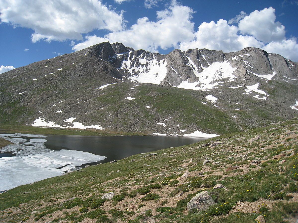
Photo by Boilerinbtown
The mountain is also the subject in one of Bierstadt’s best known paintings: A Storm in the Rocky Mountains, Mt. Rosalie.
The Mount Evans Scenic Byway/Mount Evans Highway is part of a larger network of roads that allow visitors to tour this scenery. A plan for the tourist road was instigated at the beginning of the 20th Century but only finally finished in 1930. It is the highest paved road in North America and gains almost 2,750 m (9,000 ft), finishing 40 m (140 ft) shy of the true summit.
Building progress was slow for a number of reasons.
In 1916, the newly appointed commissioner stopped work on the road, saying: “it is a road that starts nowhere, ends nowhere and never gets there”. Other set backs included a lack of funding, failed attempts to get the area designated a National Park (it became a Wilderness Area in 1980) and some unusual difficulties of building at altitude (which apparently includes horse suicide!)
GEOGRAPHY OF MOUNT EVANS
Located 96.5 km (60 miles) west of Denver, Mount Evans is the closest Colorado 14er to the city. With a driveable summit and a range of hiking routes available, it is undeniably popular among locals and tourists alike.
Mount Evans is the highest point in the Chicago Peaks massif. This massif is part of the Front Range, the chain of mountains that marks the eastern edge of the Continental Divide and the Rocky Mountains. Mount Evans can reportedly be seen to the east across the Great Plains for up to 161 km (100 miles), presumably on a very clear day.
The Chicago Peaks
This massif contains six other peaks besides Mount Evans. Such is the size of the Chicago Peaks that it is said to create its own, violent weather patterns. These are hurled towards Denver and the eastern plains daily throughout summer; a warning to climb the mountain with regular cautious glances towards the sky.
The six Chicago Peaks are all within 4 km (2.5 miles) of Mount Evans, mostly to the north and west of its summit.
These summits are:
• Mount Bierstadt – 4,286 m (14,060 ft)
• Mount Spalding – 4,219 m (13,842 ft)
• Gray Wolf Mountain – 4,146 m (13,602 ft)
• The Sawtooth – 4,202 m (13,786 ft)
• Mount Warren – 4,056 m (13,307 ft)
• Rogers Peak – 4,056 m (13,307 ft)
The Sawtooth is a ridgeline that connects Mount Evans to Mount Bierstadt. In the centre is a jagged arête that resembles the teeth of a saw. And here is where you best witness the large granite rocks precariously balancing above this broken, scattered rocky terrain.
Summit Lake
Summit Lake, north-west of the summit, is the largest and closest of a number of deep cirques that are located around Mount Evans. This mountain has the deepest cirques (bowl-shaped indentations that were carved out by glaciers) in all of Colorado’s Rocky Mountains.
Summit Lake lies at the head of Bear Creek and is a popular fishing destination. It was the first designated National Natural Landmark in Colorado and is the highest city park in North America!
Mount Evans also hosts examples of the small arctic tundras that are scattered across the massif. Unlike tundras elsewhere in Colorado, which tend to be dry and brittle, these retain pools of water after ice has melted and are located around cirques such as Summit Lake.
Mount Evans Wilderness Area
Mount Evans sits in the Mount Evans Wilderness Area. This is a protected area covering 301 sq km (116 sq miles), designated part-by-part between 1955 and 1980. The other 14er in the Chicago Peaks, Mount Bierstadt, also lies within this Wilderness Area.
The Mount Evans Scenic Byway, runs through a non-wilderness corridor that cuts through the park, (obviously, it is hard for a road to maintain the conditions of wilderness!) This creates obvious similarities with another Colorado mountain that allows you to drive to its top: Pikes Peak.
WILDLIFE OF MOUNT EVANS
Flora.
In the lower montane zones, spruce, douglas fir, and ponderosa and lodgepole pines dominate the often wet, forested valleys. Willow trees are also found in Hells Hole, to the north of the summit, featuring with very little love in many hikers’ accounts (they have to be bush-whacked through).
As you climb towards the tree line and the alpine region, the trees get older and more misshapen, varying between 2,000-year-old Bristlecone pines and twisted krummholz trees.
Above the tree line to the summit are various types of alpine-adapted plants and grass, which cover the tundra areas outside of winter. Some of the more extraordinary live near Summit Lake, and can be found only here and within the Arctic Circle.
One popular bloom, native to Colorado, is the Queen’s Crown (also known as the rose crown). This perennial herb grows up to 4 inches tall, often with many grouped close together. It has distinctive pink star-shaped flowers and is a popular feature of springtime photographs at the lake.
Fauna.
The elk found around Mount Evans are the Rocky Mountain elk, which have the largest antlers of all elks sub-species. These are grown and shed annually only by the males and are a prized trophy for hunters.
Mule deer numbers are on the decrease in this area and across Colorado State as a whole. They are the prey of mountain lions and black bears whose populations are growing, and are common victims of traffic accidents on the nearby scenic road system leading out of Denver.
In the autumn, moose also come and visit the lush lowlands as they make the most of the rich vegetation before winter sets in. This is also when the elk come down to mate, revealing their glorious antlers that have been covered in a protective skin as they’ve grown throughout the rest of the year.
Above the treeline, the quintessential climber the mountain goat is found in good numbers across the massif. Bighorn sheep, whose horns are substantially larger than the mountain goats, can also be seen scaling the rocky terrain. They mainly reside lower down the slopes than the mountain goats.
These two creatures are featured in countless images from the higher zones of the peak, surrounded by large boulders and the impressive view out over the Colorado wilderness.
FIRST ASCENT OF MOUNT EVANS
The first ascent of Mount Evans is disputed.
The first claim is from Albert Bierstadt and his guide, Williams Newton Byers, in 1863. It was Bierstadt who was responsible for initially naming this peak (see above), and also had nearby Mount Bierstadt and Bierstadt Lake named after him.
He sketched the mountain from Chicago Lakes before summiting via Summit Lake.
But a second claim came in 1872 by Judge Lunt and William Henry Jackson. They took photographs of the peak from near Summit Lake and so claimed to have clearer evidence for their ascent. However, in their claim they did refer to the peak by Bierstadt’s name, Mount Rosalie, so didn’t try to also claim the right to rename it.
HIKING & CLIMBING GUIDE FOR MOUNT EVANS
Routes up Mount Evans vary more than most, with ratings varying from class I-V (perhaps the drive up could be considered a class 0!) Many climbers will also bag Mount Bierstadt, which is a short traverse over the Sawtooth Ridge, or Mount Spalding.
Trailheads
Trailheads surround the peak, making all the different adventures to the summit of Mount Evans easily accessible. Heading clockwise around the peak, the Mount Evans trailheads are:
• Echo Lake (north): at the south-west corner of the lake, this gives access to Mount Warren and Rogers Peak and some of the longer summit hikes for Mount Evans.
• West Chicago Creek/ Hells Hole (north-north-west): gives access to the north of the massif, including Gray Wolf Mountain.
• Summit Lake (north-west of and closest to the summit): the best known trailhead, found close to the Mount Evans Byway.
• Guanella Pass (west): a very popular trailhead, giving access to many routes up Mounts Evans and Bierstadt.
• Scot Gomer Creek (south-west): nearer the Highway, gives access to the popular campsite of Abyss Lake, as well as the mountains beyond.
• Deer Creek (south-east): Has some of the best ordered trails, giving access to the southern and eastern peaks and Wilderness Area.
• Cub Creek (east): Also popular, giving access to the southern peaks of the massif and several lakes.
• Bear Creek (east-north-east): Used by hikers, fishermen and campers, giving access to the east of the Wilderness Area.
Mount Evans Hiking Routes
There are many routes on this mountain, with trails all around the peak. Here is a varied list of popular adventure options:
• Sawtooth Ridge: The popular ridgeline crossing, best accessed from Guanella Pass, involves some class III scrambling.
Best hiked from Mount Bierstadt to Mount Evans, this route first crosses an easier section, dropping to 4,058 m (13,315 ft) before climbing up to the ‘Sawtooth Peak’. Beyond, you find the talus flats that lead to the West Ridge of Mount Evans.
With the narrowness of the ridgeline, it is recommended to take this challenge on in dry conditions.
Descent is via the west slopes over grassy tundra and talus towards Summit Lake. There is some less pleasant bush-whacking required at the lower levels past the lake, but you could also arrange transport or head down back down the road.
• Snave II: The toughest climbing route on the mountain.
A class IV climb up the North Face of Mount Evans that becomes a class V in drier conditions. This is considered one of the more rewarding routes for those looking for a genuine climbing challenge.
Accessed from Summit Lake, the Snave is a large notch in the North Face. It begins with a 274 m (900 ft) scramble over scree followed by a 152 m (500 ft) wall. The route is not always marked but clearly grooved and easy to follow.
Cresting this wall you find the summit itself, so be ready for some gasps (and maybe even applause) from those stood by their cars. It is not recommended to use this as a descent route.
• West Chicago Creek: One of the longer and more solitary routes, allowing access to Gray Wolf Mountain and Mounts Spalding and Evans.
However, it is a route that gets mixed reviews, with inconsistencies between accounts leading to sections that become unnecessary and disatisfyingly difficult. This includes bush-whacking through willows on the north side of Hells Hole.
The route climbs up out of Hells Hole to gain the saddle between Gray Wolf and Point 12988, from where you can gain the three peaks mentioned.
• North Face Direct: Best climbed in winter.
A snow climb beginning from Echo Lake trailhead (a shorter alternative begins at Summit Lake). From Echo Lake, you climb towards the south ridge of Mount Warren to reach Summit Lake (around 7.25 km/ 4.5 miles). There are three possible routes, varying from the difficult cliffs that lead straight to the summit, a simpler gully to the west of it or the walk-up snowfield further west of this.
This snowfield, that can be used for a ski descent, leads to a notch on Mount Evans’ West Ridge. Find a route to the top of the ridge from here and then gain the summit that’ll be up to the east of you. Descend via an alternate route as none of these are particularly safe without decent kit.
Another snow climb is the Crystal Route, rated at class III, which can be used as an alternative descent option.
• Mount Evans Loop: Despite being only 8 km (5 miles) this route is still considered a challenging hike, beginning from Summit Lake. It gains 587 m (1,926 ft) and is seen as a good first 14er route to attempt, also bagging the 13er Mount Spalding.
INFORMATION ON TREKKING AROUND MOUNT EVANS
There are a few options for a Summit Lake Hike, including a traverse from Echo Lake along the Chicago Lake Trail or the Summit Lake Trail which begins from the opposite side of the mountain.
Due to the fragility of the tundra environment on the massif, stick to the paths. There aren’t many arctic tundra sites like this in the USA, so its up to all of us hikers to protect it for the future.
Other lake routes include the Abyss Lake Trail, heading from the Scot Gomer trailhead in the south-west or the Mount Bierstadt trail in the west.
To the east of the mountain are a lattice of trails, taking in the varied creeks in the late afternoon shadow of the mountain. This makes the Wilderness Area very simple to navigate, with many trailheads also located close to paved access roads.
For more ideas about the surrounding area, also take a look at our article on Mount Bierstadt.
For anyone more inclined to head up on two wheels rather than two feet, you could take on the Mount Evans Hill Climb. It has run (almost) annually since 1962 and was renamed after five-time winner Bob Cook, who died of cancer at just 23 years-old, in 1981.