
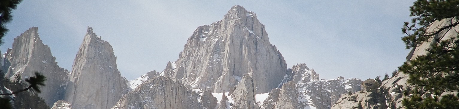
Standing in a landscape of extremes and record breakers, Mount Whitney is an American icon comparable to Half Dome, El Capitan and Yellowstone. A jagged, dark-grey mountain peak reaching out of the lush green grasslands and forests, it is the highest peak in the USA, south of Alaska.
Name: Mount Whitney
Height: 4421m (14,505ft)
Location: East edge of the Sierra Nevada range in California, USA.
First Climbed: 18th August 1873 by three local fishermen.
Climb Time: 15-18 hours via the Mount Whitney Trail.
Best Time to Climb: July - September
Introduction to Mt. Whitney.
Surrounded by National Park and forest, Mount Whitney rises above the world’s tallest trees and a sprawling wilderness of lakes, rivers and grasslands. Less than 150km south-east is the lowest point in the USA (Badwater Basin in Death Valley (-86m/ -282ft)).
Add the sheer eastern face of jagged granite that will challenge the best climbers, and the gentle western face that’s accessible by all, and the ‘very old man’ of the Sierra Nevada is an all-American adventure waiting to be explored.
Jump to Climbing or Hiking Guide
History of the mountain.
There was an estimated population of 133,000 American Indians when missionaries first arrived in California in 1770. The largest of these groups, the Yokut, inhabited the San Joaquin valley, which lies west of Mount Whitney. Although population has declined massively, (dropping by 95% by early 20th Century), California has long been an important area for aboriginal communities.
The Southern Paiute Indians call Mount Whitney, “Too-man-i-goo-yah” meaning “the very old man”. They believe that Mount Whitney has a great spirit living in it that presides over the destiny of the local peoples.
As America’s highest peak south of Alaska, you’d think that a mountain’s height was a stable thing. But not so with Mount Whitney.
The true height of Mount Whitney has long been the source of debate. It is continually reassessed as new technology claims to reveal the true measurements of the mountain. Differences in heights have varied by up to 10m over the past century, and it certainly isn’t because the mountain has grown that much! It is widely agreed that the current height of 4421m (14,505ft) is correct (for now!)

No excuses... there's a big road going there.
The mountain was named after Josiah Whitney in July 1864, the then State Geologist of California. Whitney is perhaps best known for his disagreement with John Muir, another influential geologist of the time.
Whitney believed, wrongly, that Yosemite valley was formed similarly to Mount Whitney, with land in the valley having fallen away from the higher ground. John Muir then proved that it was carved out by the actions of ancient glaciers, but Whitney is said never to have accepted this theory. He’s even said to have called Muir a “mere sheepherder” and “ignoramus”!
The first people to ascend the peak actually called it Fisherman’s Peak, in respect of them all being fishermen. This name was clearly never formally adopted however. That was also the case when there was a challenge after World War II to rename the mountain after Winston Churchill.
Despite Churchill’s heroics, Mount Whitney has endured.
Geography of Mount Whitney.
Mount Whitney dominates this wide west coast skyline. It’s the highest point of the Great Basin Divide, the Sierra Nevada and the contiguous United States, (excluding Alaska and Hawaii). It’s also the southernmost summit in US, with the nearest comparable peak 2649km (1646miles) away.
Mount Whitney is the highest part of the Sierra Nevada batholith – a vast area of granite, some of which has been exposed, along a massive fault-line. Several other famous peaks are part of this same rock formation, including Half Dome and El Capitan in Yosemite.
Mount Whitney has one gentle sloping face (west) and one sheer face (east). This dramatic difference is the result of a ‘normal fault block’: caused when tectonic plates extend or move away from one another. This results in the lower valley falling away from the higher section, leading to an appearance like a trapdoor being lifted ajar.
The granite on the summit of Mount Whitney is the same as found in the Alabama Hills to the East. All this granite was formed by volcanic activity from 90 million years ago under the Earth’s crust. More recently, it was pushed to the surface, (between ten and two million years ago), while much of the rock it’s connected to remains hidden underground. Natural erosion, including the action of now absent glaciers, wore away the softer sedimentary rock on top, revealing the signature jaggy outlines that are its signature.
To the West is Sequoia National Park, accessed from the summit by San Joaquin Valley. Beyond this is a vast area of wilderness including the rest of the Sierra Nevada: a great sweeping chain of mountains in the shape of a boot that stretches along two-thirds of California’s east.
To the East is the Inyo National Forest. It begins with a sudden drop into the arid Owens Valley (3285m/ 10,778ft) which runs north-west to south-east from Mono Lake to Owens Lake. To the North-east are the Inyo Mountains that lead down into Death Valley – the hottest, driest and lowest of all the National Parks.
- Read about other important US & North American mountains in our Mountain Info Page
- Read our Introduction to the Colorado 14ers
Wildlife of Mount Whitney.
Fauna:
Given the rocky terrain, most animal life on Mount Whitney is transient above the tree-line. One regular inhabitant is the gray-crowned rosy finch. Used to the colder climate of Alaska, Canada and northern Montana, this little bird lives in open country year-round. It is identified by the grey covering of the top of its head that looks like a hat or, indeed, crown.
Small mammals such as marmots, mice and squirrels can be found running through the forests and grasslands of the lower slopes. Mostly herbivorous, these creatures hibernate through the challenges of winter so you’ll likely only see them during the summer months. Marmots in particular feature in many accounts of adventures around the mountain, some hikers even sounding fed up of seeing them scamper by!
One inhabitant you might wish to see only at a great distance is the black bear.
More common in Sequoia National Park, these huge creatures are well-known to cause damage to vehicles, tents and cabins in search of food. If you’re heading out, follow the guidelines of park rangers, keeping food in specially designed bear-proof lockers where provided and, if they’re not available, keep food far from your tent.
Flora:
While there are far more impressive trees to the north and west in the neighbouring national parks, Mount Whitney’s forests are a uniform display of pine forests. These provide the habitat to most of the wildlife on the mountain’s slopes, and break up the shades of grey and blue that make up much of the landscape.
The density of the pine forests varies greatly. On the east side of Mount Whitney the forest ends abruptly at the tree line around 700m (2297ft) as the challenge of sudden elevation is too great. In the west the distribution is more patchy as while the elevation rises more slowly the ground is generally more unpredictable.
One high flying plant is the Sky pilot - a cushion plant that grows over 3000m (9843ft). With a head of bright purple flowers and a distinctive musky smell, this plant is a highly prized find for wildflowers enthusiasts. Endemic to the Sierra Nevada, it’s often found growing amongst the scree on the higher slopes.
The scientific name for a Snow plant (Sarcodes sanguine Torr.) roughly translates as”the bloody flesh-like thing”. It is a squat, red plants growing amongst rocks, and derives nutrients not from the sun but from fungi underneath he soil. Snow plants are more often confused with chunks of meat, though hopefully not by bears!
The dramatically named Pacific Bleeding Heart plants is named after its small pink/red flowers that hang in the shape of a heart. It has been used for pain relief and to calm nervousness and panic. Found in the lowland pine forests and grasslands, the plants spread with the help of ants. They carry the plant’s seeds to their ant hills and eat the tasty white appendages to the seeds. The discarded seed then sprouts from the ants’ refuse pile.
Description of first climb of Mount Whitney.
Now the most frequently climbed peak in the Sierra Nevada, the first successful ascent happened on the 18th August 1873. Charles Begole, AH Johnson, John Lucas were the three men who successfully completed the challenge.
But these men weren’t the type of intrepid and experienced explorers that claimed many first ascents around the world. They were local men from nearby Lone Pine, and all three were fishermen.
But it is a story of failure rather than success that is worth telling: the story of Clarence King.
In 1864, during the expedition when Mount Whitney was named, King attempted to climb to the summit via the gentler western slopes but he came up just short. In 1871, he believed he had achieved the first ascent, and held onto this belief for two full years.
But in 1873, he discovered that he had in fact reached the summit of nearby Mount Langley. He finally reached the summit of Mount Whitney later that year – a matter of weeks after the first successful summit by the local fishermen.
Climbing guide to Mount Whitney.
However you approach Mount Whitney, be ready for loose rocks, boulders and switchbacks. Also be prepared for the effects of altitude sickness and, if in doubt, head back down the mountain if symptoms persist.
The Mount Whitney Trail (35km/ 22mile return) begins 21km west of Lone Pine at Whitney Portal (2550m/ 8360ft). Normally takes two days, staying at Outpost or Trail camps, but can be achieved within a day (15-18hours of walking). It is considered a strenuous, occasionally steep, but not technically challenging route.
Beginning at the Whitney Portal Store, you ascend passed Lone Pine Lake (2871m/ 9420ft) to Outpost Camp (3158m/ 10,360ft). Head from here to the eastern end of Mirror Lake (3188m/ 10,460ft), then follow the southern edge into switchbacks through woodland to the Trailside Meadow (3473m/ 11,395ft). In summer this is a meadow full of granite rocks, in winter a snow field.
Follow the north side through Trail Camp (3669m/ 12,039ft) to Trail Crest (4199m/ 13,777ft) and the entry into Sequoia National Park. This section represents the hardest part of the climb. Head down to the John Muir Trail Junction (4109m/ 13,480ft), taking the right hand route to follow the back of Mount Muir and the needles up to the summit (4421m/ 14,505ft), which will be visible from quite a distance. The views in this section are stunning and worth the effort of the climb.
Permits from the National Park Service are required year-round, with a limited number available by lottery from May to November. One day permits are easier to obtain, probably because fewer people feel the desire to take on such a long one-day challenge. In summer, this route can be achieved with virtually no hiking equipment, even in trainers, though ice axes and crampons are needed in winter.
The Mountaineer’s Route is a faster and quieter route that can also be climbed year-round. Again, permits are required so apply in plenty of time, and again allow for two days, with camping at Iceberg Lake (1878m/ 6160ft).
Taking the same starting point as the Mount Whitney Trail, the first section is a hike over to Iceberg Lake (4-6hours). From the lake, head up to Mount Whitney’s North Ridge over loose rock and sand. Cut west along a traverse that brings you to the base of the summit plateau, which you ascend to the east.
Although not an overly technical route, there are some challenges with sections of scree, scrambling and exposed ledges. In winter, extra care should be taken near the summit where ice patches on the slopes can lead to unintended fast accelerations back down the way you came. With fatalities most years, particularly in winter, ensure you take this challenge prepared.
The East Face and the East Buttress routes offer excellent technical climbing opportunities.
Both have routes that are graded from class 3/4 upward, meaning that free and rope climbing will be needed during a climb. It also suggests that the danger posed by this route could lead to a fatal fall. No climbing route should be under-estimated or attempted without sufficient expertise or enlisting the support of an adventure guide, and these are no exceptions to that rule.
There are a series of needles, or minor summits on the East face, which present some of the best climbing challenges in the High Sierra. One of these ‘needles’, Crooks Peak, was named after Hulda Crooks who hiked the mountain annually until her mid-nineties.
A sign, if needed, of the life-long health benefits of mountain adventures!
HIking around Mount Whitney.
The John Muir Trail is a very long trekking route from Yosemite National Park to Mount Whitney. It stretches north to south over 346km (215miles). It is usually divided into 30 easy-going day-long sections. Highlights include Half Dome, multiple crystal clear lakes and endlessly inspiring views.
- Read our guide to the Top Long Distance Hikes in USA & Canada
- Find the book you need about for the Sierra Nevada; including hiking guides, climbing guides and fishing guides
- What to take on a hike
Mount Whitney is the end point of this long hike, which enters Sequoia National Park from the north via the Forester Pass (4011m/ 13,160ft, the highest pass on the trail), and cuts east before Whitney Creek to ascend Mount Whitney via the Trail Crest (part of the Mount Whitney Trail).
Coming from the West is another multi-day hike and it was the first sierra trail built exclusively for recreational challenges, (completed in 1934). The High Sierra Trail is a 79km (49mile) west to east traverse of the Sierra Nevada.
Beginning in Crescent Meadow (1981m/ 6449ft) it passes through the lowest pass in the Great Western Divide, (Kaweah Gap (3261m/ 10,699ft)) to arrive at the the point where the John Muir Trail cuts east towards Mount Whitney. An easy path, allow 4-6 days to complete this adventure.
Head north to walk among giants. Sequoia trees are the biggest in the world, and the mightiest of all are found in California within a few hours drive of Mount Whitney. A place for gazing up and enjoy gentler walks, this is a picturesque option for an adventure with a little less physical challenge.
Moro Rock, a granite dome on the border of Sequoia and Kings Canyon National Park, has a short staircase to panoramic views of the Great Western Divide and the surrounding giant trees.
The Badwater Ultramarathon a 217km (135mile) race that finishes at Mount Whitney. Starting at Badwater Basin in Death Valley, this is a run from the lowest to the highest points in the United States. This was first completed in 1969 and has been an official race since 1987. The fastest time is just under 22 hours, set on 20th July 2016.