

By garrulus
Separating the Iberian Peninsula from the rest of mainland Europe, the Pyrenees Mountain range is a haven for adventure, stretching from the Atlantic Ocean in the West to the Mediterranean Sea in the East.
Names: The Pyrenees, (Pirneos (Sp) / Pyrénées (Fr) / Pireneus (Catalan)
Highest Point: Aneto Peak (Pico de Aneto (Sp) / 3,404m (11,168ft).
Length of Range: 270 miles (435km)
Maximum Width: 80 miles (130km)
Location: Runs along the border between north-east Spain and south-west France. Bay of Biscay (west, Atlantic Ocean) to Cap de Creus (east, Mediterranean Sea).
First Ascent of highest peak (Aneto): 20th July 1842 by Count Albert de Franqueville, Platon de Tchihatcheff, two local guides and two Isard hunters.
Introduction to the Pyrenees
Separating the Iberian Peninsula (primarily Spain and Portugal) from the rest of mainland Europe, the Pyrenees stretch from the Atlantic Ocean in the West to the Mediterranean Sea in the East. The French / Spanish border winds through the range and the tiny principality of Andorra is entirely contained within it.
The Pyrenees is a place for a range of adventures and challenges. It hosts three of the great long walks of Europe: the GR10 along the French side, the GR11 along the Spanish side and down the middle is the HRP. It is also a place visited annually by cyclists on Tour de France, and contains some of Europe’s premier ski and snowboard locations.
Jump to Walking and Climbing Route Guide
There is a great variety of wildlife found in the Pyrenees thanks to its diversity of terrain and weather. The dry South and East areas contrast with the wet North and West, giving rise to ideal habitats for over 3,000 plant species and vibrant animal and bird populations.
- Browse a list of guidebooks for the Pyrenees
- Browse a list of the top Long Distance Walks in Europe including the HRP.
The Pyrenees is also known for its cuisine and history. Evidence can be found of human settlements along this range from prehistory, through the great empires of Europe to modern day, where multiple cultures give rise to a plethora of linguistic and culinary experiences that few ranges around the world can boast. And it has therapeutic waters too, according to hundreds of years of tradition, giving rise to plenty of spas to ease tired bodies through their toughest challenges.
A Note About Language.
The Pyrenees stretch along the entire border dividing France and Spain. On the Spanish side, it passes through the culturally and linguistically diverse regions of Catalonia, Aragon, Navarra and the eastern edge of Basque Country. As such, there are often three or more translations of names or terms: English, Spanish, French and local dialects such as Basque (West) or Catalan (East).
Throughout this article, I will refer to the English, or preferred, name. However, at its first mention I follow it with the relevant equivalents in other local languages, for reasons of both interest and information.
Geography of the Pyrenees.
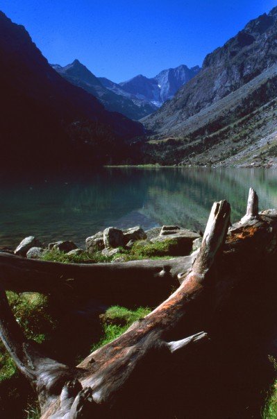
The Armchair Mountaineer at Lac de Gaube, Pyrenees.
Given that the range marks the border between two countries, (mostly along the high-point or watershed), it’ll come as no surprise that the Pyrenees are divided in two: the French Pyrenees (north) and the Spanish Pyrenees (south).
Typically, the French Pyrenees are wetter, greener and stepper and contain the great torrents known as gaves and the natural amphitheatres or cirques. The Spanish Pyrenees are much dryer, more barren and have a steppe-like geography.
West to East there are further sub-divisions: the range runs through six French regions and four Spanish regions, (Catalonia divided further still into three discrete provinces, including Barcelona, Spain’s second biggest city).
The highest of the range’s mountains are found in the Central Pyrenees (Midi-Pyrênêes (Fr)). This area contains the enormous Parc National des Pyrénées in France and the Parque Nacional de Ordesa y Monte Perdido and Parque Nactural Posets-Maladeta in Spain. There is an average snow-line in the Pyrenees around 2,700m (8858ft), though some areas have a permanent snow-line as low as 1830m (604feet).
The Western Pyrenees rise gradually from the Atlantic and Basque country and contain some of the most well-known passes, including the “Napoleon route’ of the pilgrimage Camino de Santiago, which runs from St-Jean to Roncesvalles in Navarre. The Eastern Pyrenees, from Andorra to the Mediterranean, is more uniform in height. Pic du Canigou is the last significant peak at 2785m (9137ft) before the range descends to the Cap de Creus. Andorra’s capital, Andorra la Vella, is the highest in Europe at 1023m (3356ft).
The Pyrenees are very old, older actually than that other great European range the Alps. They were formed over the course of around 100million years, with the last major activity around 40million years ago, as the land we know as Spain pushed itself into France. The mountains are predominantly granite, a tough rock which is highly resistant to erosion, and so are relatively unworn. However, the lowlands in the western area are flanked by limestone which is more easily eroded. The minerals iron, lead, silver and cobalt are also all found in the Pyrenees.
Currently the Pyrenees has few significant glaciers, most of which are predicted to disappear by 2050, but the deep valleys show that this has not always been the case. The valley of Ordesa in Aragon is an example of this history - a valley 1,000m deep once carved out by a huge glacier.
A number of significant rivers surge out of the mountains. The Aude, Ariège, Garonne and Adour run north into France, along with numerous gaves in the western region of the Pyrenees-Atlantic (Pyrénées-Altantique). The Ter, Sègre, Cinca, Aragón and Gállego run south into Spain.
Wildlife of the Pyrenees.
Fauna:
The Pyrenees is rich in animal life. Mammals of all sizes, birds as well as insects and butterflies line the mountain slopes.
Particularly found in the Ordesa valley, the Pyrenean Chamois (Isard (Fr) / Sario (Sp)) is a goat or antelope-like animal found bounding across ridges and up near-vertical mountain ascents. Recognised by its curved horns, white tail and dark brown stripe from muzzle to ears, these adventurous animals travel in herds of up to 100 individuals. Once in decline, with only 1300 left in 1967, they now have a strong population of around 5000 individuals.
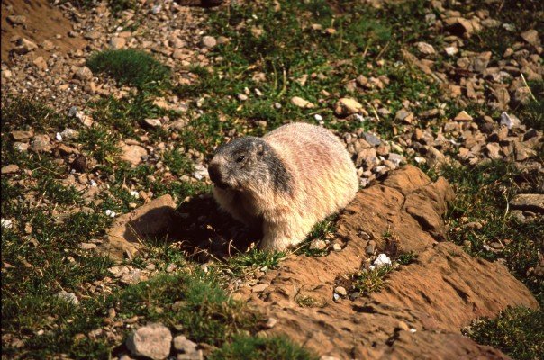
Marmot looking at The Armchair Mountaineer.
Found at both sub-alpine and higher elevations, the Alpine Marmot was successfully reintroduced to the Pyrenees after their disappearance in the last ice age. Seen in summer, these large, herbivores rodents are absent in winter as they have a long hibernation.
Unfortunately not all human interventions are so successful. The challenge of improving the dwindling numbers of European Brown Bears was attempted in 1996, but suffered the loss of one of the two breeding females a year later. The smallest in the brown bear family, they came near extinction after excessive hunting in the 1980s, however, since their re-introduction (from Slovenia) in 2005 they have been making somewhat of a comeback. Recent reports say there are 30 bears (largely in Catalonia). The Cantabrian Brown or Eurasian Brown bear found in the Cantabrian Mountains in North Western Spain is more numerous.
Other animals that can be found here include Red Squirrels, Pine Martens, Red Foxes, Badgers and soaring overhead you might be able to spot a majestic Griffon Vulture, Egyptian Vulture or the mighty Lammergeier.
Flora:
The ‘Flower Garden of Europe’, the Pyrenees is a place that blossoms into an array of colour in the late Spring months of June and July. The best of the blooms can be found in the greener French Pyrenees and in the Central region.
There are over 3000 species of plant found in the Pyrenees, 180 of which are endemic. These include:
- Trumpet Gentiane, which has a deep blue trumpet shaped flower,
- English Iris, a blue flowering plant growing up to 40cm tall,
- Numerous orchids including the burnt, black vanilla and pyramid varieties, and
- Pyrenean Buttercup, a pink bloom that can flower even before the snow has disappeared!
Trees are also varied and populous in the Pyrenees. The tree-line reaches as high as 2,600m (on the southern slopes of the Neouvielle Massif), where the Pyrenean Mountain Pine are found. Descending the mountains from this point are Black Pines (up to 2100m), Scots Pine, Beech, Silver Fir, Birch and Poplar (over 1000m) and in the lowlands you’ll find Maple, Hornbeam, Sweet Chestnuts and Oaks.
Walking and Climbing in the Pyrenees.
Key Mountains:
Extraordinarily, even thought the highest mountain is only 3404m, there are 129 Three-Thousanders in the Pyrenees, (mountains between 3000m and 4000m above sea level). The range as a whole is divided into 11 discrete zones (to add yet more sub-divisions to this range!), but the majority of the highest mountains are found in the Central region of the Pyrenees,.
The five highest mountains, followed by the zones they are found in, are:
- Aneto Peak (Pic d’Aneto (Fr) / Pico d’Aneto (Sp)) – 3404m (11,168ft) in Maladeta-Aneto, Spain,
- Posets Peak (Pico Posets (Sp)) – 3375m (11,073ft) in Posets-Eristé, Spain,
- Monte Perdido (Mont Perdu (Fr)) – 3355m (11,007ft) in Monte Perdido, Spain.
(This Massif contains three peaks known as the Three Sisters (Las Tres Sorores (Sp)) consisting of Monte Peridido, Cilindro de Marboré – 3335m (10,942ft) and Soum de Ramond – 3254m (10,676ft)), - Espadas Peak (Pico Espadas (Sp)) – 3332m (10,932ft) in Posets-Eristé, Spain,
- The Vignemale (Pique Longue (Fr)) – 3298m (10,820ft) in Vignemale, France – the highest mountain in the French Pyrenees.
- Pic du Taillon (3144m (10315 ft) on the border of France and Spain, through the Brèche de Roland.
Key Trekking routes:
The Pyrenees are home to three of the great hiking challenges of Europe: the GR10, GR11 and HRP.
GR is the term applied to the main hiking routes through Europe, translating as the Grande Randonnées in French and Gran Recorrido in Spanish. The HRP, which follows the highest elevations along the mountains, is the Haute Route or Haute Randonnées Pyrénéenne.
- Browse this list of guidebooks to the GR10, GR11 and Haute Route.
- Browse a list of the top Long Distance Walks in Europe including the HRP.
In the French Pyrenees, the GR10 runs for 866km from Hendaye (west) to Banjuls (east). First compiled as a route in 1964, the GR10 takes around seven weeks to complete. During this time you walk though rolling hills, pass mountain lakes and shepherds cabins, as well as witness the gaves and cirques for which the French Pyrenees are famous.
As the valleys run perpendicular to the route, the challenge of the GR10 is the up-and-down nature of the adventure (exceeding 49,000m gained and lost in total). Given the regularity of villages and less steep (if more numerous!) climbs, this is a route that is widely rated as non-expert.
GR11 (or Sendero Pirenaico (Sp)) runs through the drier and more barren Spanish Pyrenees on the south side. Starting at Hondarribia (west), the adventure takes you through the mountains of Navarra, Aragon and Catalonia to the Cap De Creus in Girona. Its 840km route is divided into 46 day-long sections, each beginning and ending in a campsite, town, refuge or hostel. The route passes through far fewer villages than on the GR10, so you’ll need to be more self-sufficient.
Generally considered a harder route than the GR10, the GR11 has changes in elevation of up to 1600m per day and passes above 2500m in the Central Pyrenees. At the eastern end, the presence of peoples from prehistory onwards are easy to see, with megalithic monuments (Mores Altes I and II), Roman and Greek vineyards and olive groves and Benedictine Monasteries dating from before 1000AD.
There are a number of passes with which to switch between the GR10 and GR11. Given the drastic differences in weather and terrain, this is an option that is well-worth considering when planning your adventure.
The HRP follows the high passes and cols and criss-crosses the border between France and Spain. Dramatic ridge-lines, high passes and variable weather are trademarks of the tough challenge posed by the HRP, requiring a good level of fitness and experience in order to attempt. More challenging than either of the Pyrenees’ GR’s, you’ll need to be largely self-sufficient during the HRP.

Take note that the HRP, unlike the well-marked GR’s, is not a formally marked trail. As such, way-marking can be variable at best. This does allow you to take more of your own route, making it more or less challenging or taking in unmissable places with detours along the way. The best months to take this adventure are July and August, when the passes are clearer and the weather is more predictable.
The Pyrenees are full of shorter multi-day adventures too:
- The Gavarnie-Ordesa circuit is a loop through the Haute Pyrénées which takes in the famous Cirque de Gavarnie and the 15km Ordesa Canyon.
- To the west is the French route of famous pilgrimage the Camino de Santiago, a 769km challenge that finishes in Santiago as Compostela, Galicia and crosses the Pyrenees between St.Jean and Roncesvalles via the Roncesvalles Pass.
- To the east is the history-laden Sentier Cathar, which winds through the foothills of the eastern French Pyrenees amongst its ‘Castles in the Sky’.
Summitting.
Many of the mountains along the Pyrenees can be summitted, either with the support of professional adventure guides or, with sufficient preparation, without them. As with all such adventures, ensure that you research each summit and route in detail and ensure that you are cautiously and thoroughly prepared for the challenge.
The highest mountain, Aneto Peak, is serviced by a number of adventure companies who can take you up. Alternatively, head-up without guides from the Refugio Renclusa early in the morning to achieve the summit and return within a day.
The highest on the French side, Grand Vignemale, is also a good challenge but still plenty doable. Using the Refuge Bayssellance as a starting point, the highest hut with guardians in the Pyrenees at 2651m, this summit can also be achieved within a day.
Other Adventure Sports.
For those searching for a challenge outside of hiking, there are plenty available throughout the Pyrenees. Skiing and snowboarding, as with most mountain ranges, is a sure bet, with numerous, highly-rated resorts along the range.
- Canyoning - Consisting of following the river downstream I whichever way you can, this adventure offers challenges like swimming, jumping, climbing and abseiling down the many canyons in the Pyrenees. There are numerous operators on either side offering canyoning holidays, which are obviously best taken during the warmer summer months!
- Kayaking – Perhaps you’d rather stay out of the water (to some extent!). If so kayaking, or rafting, is available along those same fast-moving waterways. Not to be underestimated, some routes offer the challenge of white water kayaking.
- Cycling – If it’s good enough for the Tour de France, it’s good enough for an adventure holiday! Cycling through the Pyrenees is a challenge taken on by many cyclists each year, following the route of the Tour, or taking their own direction. There’s plenty of advice, unmissable routes and information available for anyone keen for a two-wheeled adventure
Getting to the Pyrenees.
With a number of major towns and cities either side of the range, air and train travel can get you relatively close to the Pyrenees. To get into the mountains, however, road is your best bet.
The A64 (west of Toulouse) and A61 (east of Toulouse) run along the north of the range, serving the smaller roads which lead to the villages lining the bottom of the mountains as well as the numerous passes. On the Spanish side, major roads lie further from the range, so you’ll need to allow more time to get up to the mountains from this side.
The range itself is traversed by a number of roads (seven), of which some climb across high passes (four) and others use tunnels (three). In France the A63 (St.Jean) and the A9 (Perpignan) cross the Pyrenees at west and east ends respectively. They become the AP8 (Irun) and E-15 (Girona) as they cross the border. Two railway lines also cross the Pyrenees, one at either end of the range.
Trains in France fly south from Paris, making the trip from capital to slopes doable in a day. The TGV (Train aver Grande Vitesse) heads to Toulouse, from where you can catch an evening train or bus into the villages along the bottom of French Pyrenees. From Spain, trains are less well distributed along the range, though you can arrive from Barcelona in the village of Puigcerdà as one option.
Eleven large airports serve the mountains and Andorra, which is only accessible by road:
Airports in France:
Toulouse,
Carcassonne,
Perpignan,
Biarritz,
Pau, and
Tarbes-Lourdes.
Airports in Spain:
Barcelona,
Girona,
Pamplona,
Zaragoza, and
San Sebastien.

LATEST BLOG POSTS
I quit the rat-race to live a more adventurous life. This is my journey.