
The continent of South America is blessed with high mountain ranges, accessible peaks and a history of human ingenuity dating back hundreds, if not thousands, of years.
From the summit of Aconcagua and the steppes of Patagonia to the ruins of the Incas and a long walk down the spine of the Andes, South America hosts hikes that satisfy physical, historical and spiritual desires.
Here are five of the best South American multi-day and long distance hikes to get you excited about your next adventure.
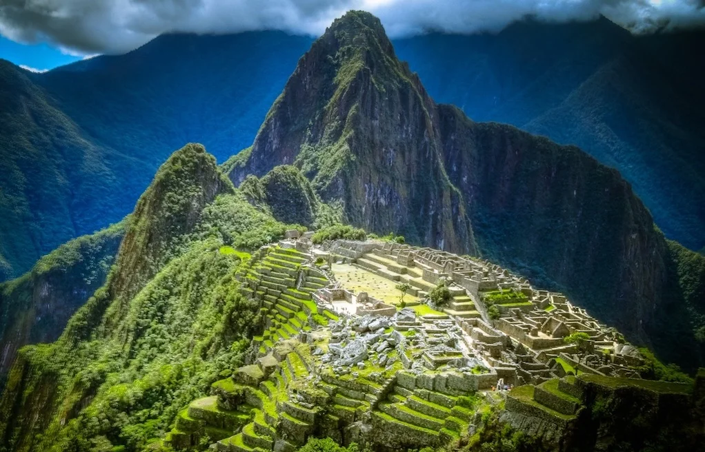
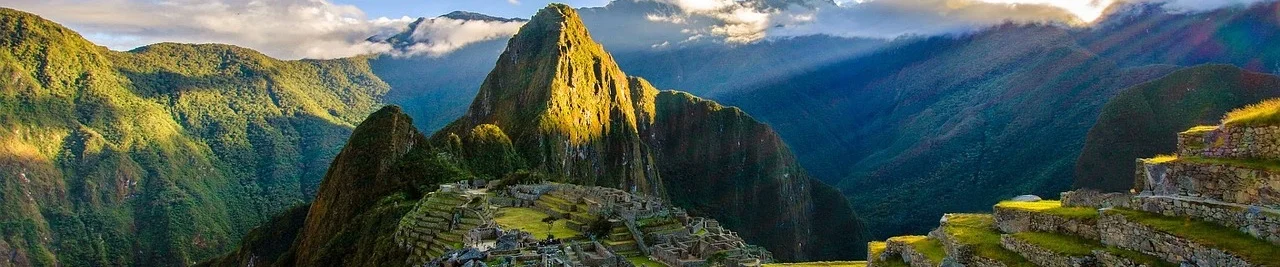
Inca Trail to Machu Picchu (Peru)
From/to: Km82-Machu Picchu
Distance: 45 km (28 miles)
Walk time: 4-5 days
When to walk: April-October, though possible year-round (except February)
Short description: One of the world’s great walks, this short multi-day hike takes in Inca ruins along a route of high passes, stone staircases and stunning history before revealing its crowning jewel: the city of Machu Picchu illuminated in the dawn light.
Among a network of 40,000 km (about 25,000 miles) of Inca trails, which connected the ancient South American empire, this 45 km (28-mile) section from Km82 to Machu Picchu is one of the more famous and, arguably, one for the world’s great walks.
The Incas built the largest pre-Colombian empire in the Americas along the mountainous west coast of South American during the 15th and 16th Century. It was an extraordinary political, militaristic and religious achievement, and the ruins that remain draw deservedly awed reactions.
This Inca Trail begins at the trailhead Km82 (2,600 m/ 8,530 ft, 82 km/ 51 miles by train from Cusco). Beginning by hiking north alongside the Cusichaca river, ascending and descending the valley. It passes an Inca hill fort before climbing to Wayllabamba (3,000 m/ 9,843 ft), the ‘Grassy Plain’.
The route undulates through two more days of strenuous but extraordinary hiking, following original Inca trails across passes, stone embankments, endless staircases and visiting ruins. The high point is Warmiwanusca Pass (4,200 m/ 13,780 ft).
The final day is a short 6 km (3.5 mile) ascent from the Trekkers Hostal. Begun at 4.30 am, most hikers take in the extraordinary view of the ruins of Machu Picchu (2,400 m/ 7,874 ft) in the dawn light (around 6 am).
Some of the highlights (there are too many to list) on this extraordinary trail include: Sayacmarca, the ‘Inaccessible Town’ protected by sheer cliffs on three sides; Phuyupatamarca, the ‘Town in the Clouds’ accessed by a thousand steep stairs; and the various passes with views of snow-capped peaks.
There are also a number of former ritual sites, where Incas washed and worshipped as they travelled to Machu Picchu. These ruins reflect the route’s historical importance, offering today’s hikers a sense of being a part of something that stretches back many hundreds of years.
The classic itinerary is four days from trailhead to the famous city, arriving there at sunrise of the last day. Around 90% of hikers opt for this. The promise of this final view is the best way to enjoy one of the wonders of the ancient world.
After the hike, most people stay an extra night in Agua Calientes, perhaps returning to the ruins during the following day, (though daytime Machu Picchu is decidedly more busy).
This route is very popular, with hundreds taking it each day in the peak season (June-August). So, book ahead and come prepared for an absence of solitude. Most hikers use local tour operators.
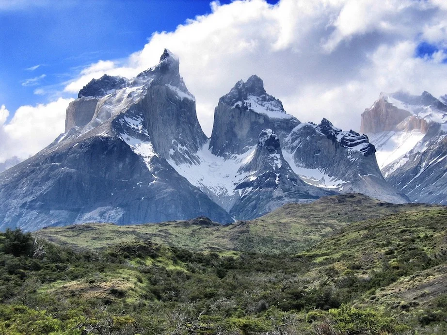
W-Trail & Paine/O Circuit, Torres del Paine (Chile)
From/to: Refugio Grey (W-Trail), Refugio Las Torres (Circuit)
Distance: W-Trail is 71 km (44 miles), Paine Circuit is 110 km (68 miles)
Walk time: W-Trail is 4-6 days, Circuit is 8-9 days.
When to walk: October-April
Short description: Two routes navigating around the narrow towers of Torres del Paine in northern Chile, winding in and out of the complex of peaks and getting up close to a glacier and crystal clear lakes.
This trek’s curious name is answered by a look at a trail map. One is a circuit (hence ‘O’) around the many rocky summits on the eastern edge of the national park, the other is a W-shaped route winding into and out of their valleys.
The walks wind around a giant massif that contains some 24 summits. The eponymous peaks are the three narrow towers in the north-east of the massif: Torre Norte (2,248 m/ 7,375 ft), Torre Central (2,800 m/ 9,186 ft) and Torre Sur (2,850 m/ 9,350 ft). Yet the highest peak is on the opposite side: Cumbre Principal (3,050 m/ 10,007 ft).
This walk takes place in the Torres del Paine National Park in Patagonia. The national park was voted the fifth most beautiful in the world by Natonal Geographic and has been a UNESCO Biosphere Reserve since 1978.
The jagged towers dominate a largely forested landscape that is dotted by glacial lakes, waterfalls, and smaller snow-capped, ice-wrapped peaks.
To the north-west is the giant southern Patagonian ice field, the second largest extrapolar ice field and the source for these lakes. Extending close to the western side of the peaks is the Grey glacier, a 28 km (17-mile) ice river ending at Lago Grey.
Both hikes are strenuous and challenging but non-technical. The circuit takes around nine days while the W-Trail takes from four to six.
The W-trail typically begins on the western side, from the foot of the Grey glacier. It begins with the easiest of the walking passing along the shore of Lago Grey.
The trail then wraps around the south-west of the massif before crossing Rio Francés and walking alongside the glacier and waterfalls up Valle Francés . The end of the valley offers views of Los Cuernos and Las Torres.
Backtracking to the valley entrance, you continue along the south-east of the massif to the last section. This is an hour-long scramble over boulders in the valley of the Rio Ascensio to the Mirador base to view the three towers of the Torres Del Paine.
The circuit is basically a simple circumference route that continues this route up around the north of the massif (though normally the two valley walks from the W-Trail are not included). Typically begun at Refugio Las Torres, the sections along the eastern and northern sides follow the Rio Paine as it leads thorough the glacial lakes: Lago Dickson and Lago Paine.
Along both routes are various refuges and campsites, though peak season requires early booking.

Lost City Trek (Columbia)
From/to: A circuit from Machete.
Distance: 46.6 km (29 miles)
Walk time: 4-5 days
When to walk: Year-round, though December-March and July-August are drier.
Short description: A rainforest hike to Columbia’s Lost City, discovering a landscape and history that stretches back over a thousand years.
La Ciudad Perdida, Columbia’s Lost City, is an adventure through the rainforests, valleys and the Sierra Nevada Mountains in the north of the country. The unexpectedly extensive final destination, which was known as Teyuna, was the capital city of the former civilisation, the Tayrona.
The route is largely a dirt and rock track through rainforests, with the occasional river crossing (Rio Buritaca) and regular opens to reveal expansive views across the lush landscape. On day one of four, you cross the river in a cage operated by an ageing pulley system!
All treks begin and end at the trailhead in Machete, though they really begin 45 minutes drive away in Santa Marta. Supplies on the trail are carried by mules and horses, so meeting these regularly is probably a good sign that your campsites will be well stocked. Mostly itineraries are four days, though you can opt for five and take a bit more time.
The approach to the Lost City occurs on day three, and consists of 1,200-1,800 stone steps (accounts vary). This is no easy climb, and given the age of the stones they can be uneven and slippery, so some scrambling may be required, or preferable.
During the route there are a couple of stone structures, where this guide advises his hiking clients to “let go of our impurities, our negative thoughts and emotions”.
Arriving at the lower chambers of Teyuna, you walk into a place that was built 600 years before the Inca’s built their empire. From 800 AD until the arrival of the Spanish in the 16th Century, the Tayuna people occupied this city. Fleeing it rather than letting the Spanish find it, it was consumed by the jungle for the next few centuries, known only to local shaman.
In the 1970s it was ‘re-discovered’ by the western world, and after a short but devastating period of looting (leaving the details of Tayrona people a mystery), the site is now a cherished part of north Colombian cultural heritage.
From the lower terraces, you walk up through the upper terraces, which look like elevated golf greens surrounded by stone structures. After your visit you turn around and head back along the track to the start, where the custom is to offer your walking stick to new trekkers back near the start.
One clear connection to the traditional culture is the indigenous people who often act as guides for hikers.
Using a Wiwa guide, one of four local peoples believed to be Tayrona descendants, gives you insight into the trail beyond the stunning nature, delving into the why’s and what-for’s of the various monuments and structures encountered during the trek.
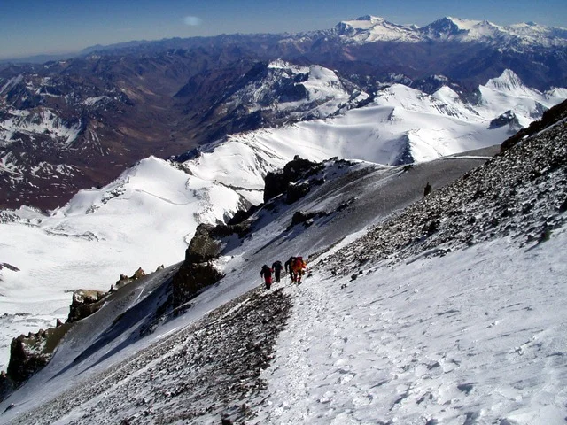
Aconcagua Ascent (Argentina)
From/to: Puenta del Inca to summit of Aconcagua (6,959 m/ 22,831 ft)
Distance: 41 km (25.5 miles)
Walk time: 10-14 days
When to walk: December-March
Short description: Stand above every continent except Asia on the summit of the Seven Summits 2nd highest mountain.
Beyond the mighty ranges of Asia, no other peak reaches higher. And yet, the South American giant, Aconcagua, offers a non-technical ascent that, in a little under a fortnight, could have you standing on top of South America, the Andes and the second most prominent peak in the world (after Mount Everest).
There a few different routes up to the summit of Aconcagua. For a long time, it was believed to be a volcano, as many other peaks along the spine of South America and the Argentina/Chile border are. This logic would be supported given the gradual incline of some of its slopes, and yet it is a mountain, simply pushed up from the action of tectonic plates.
The Normal Route, which heads up the North-west Ridge, is the most popular. It is, unofficially, the highest non-technical ascent in the world. True to this, altitude the primary danger on this hike, making acclimatisation the main preparation required.
With at least four camps to reach, stock and move on from, and a total elevation gain of 4,219 m (13,842 ft) from the start of the approach at Puenta del Inca, this trek requires around two weeks to complete. Though non-technical, not all summit attempts are successful; around two-thirds fail to reach the pinnacle.
Other routes include the Polish Glacier Route, which climbs from the North-east. Unsurprisingly, this technical route requires ice climbing and hiking, given that the majority of the route follows the long Polish glacier. As such it is a route, which includes a very long summit day, that is reserved for more experienced mountain climbers.
Three other routes—a variant of the Polish Glacier Route and two that ascend the more heavily glaciated southern slopes—are considered significantly more technical and are rarely attempted.
Hiking up the Normal Route and summitting the second highest of the Seven Summits is a real possibility.
While not the longest hike you may take in South America, it certainly is a unique offering in the world of long distance hiking, comparable only to the walk-up ascents offered by a number of volcanoes around the world, such as Mount Fuji in Japan.
Greater Patagonian Trail (Chile/Argentina)
From/to: Randal (Chile) to Villa Rivaderia (Argentina)
Distance: 1,407 km (874 miles)
Walk time: 90-120 days
When to walk: December-March
Short description: South America’s longest trail is an unofficial route down the spine of western Patagonia, winding across the range, its rivers and high passes.
Travelling through the heart of the Patagonian Andes, the Greater Patagonian Trail (GPT) explores a diverse landscape that includes volcanic fields, lush forests and snow-capped peaks. An unofficial trail, this hike is more a guide, as you cut your own route through the South American wilderness.
Good planning, endurance and navigation skills are key to a successful GPT. But the rewards are enormous for the well-prepared. From river crossings to cutting a new trail when the ‘existing’ one is no more are all part of the challenge of this magnificent walk.
The route is typically taken southbound from Radal near Curico, Molina in Chile. The 18 stages, as defined by the German who first cut the route, Jan Dudeck, culminate in Villa Rivadavia in Argentina.
During the route, you mainly walk along the Chilean side of the border. In the south, as the border climbs more into the centre of the mountain range, there are points where you cross into Argentina, including at the very end.
The majority of the path will be shared with only herdsman, horses and other hikers, as 88% of the route navigates remote dirt tracks and unpaved roads, now only navigable on foot.
Many of the hiking trails are maintained by local herdsmen, used to guide their livestock through remote valleys and mountain passes.
This all shows you the solitude and remoteness that this, the longest trail in South America, offers you; perhaps comparable to only a few other trails in the world. In fact, around 111 km (69 miles) of the trail is still unmapped by GPS and almost the entire route is unmarked.
To complete the whole trail, you’ll need 90-120 days. Leaving in December uses the favourable summer season. However, even in this season, storms, heavy rain and even snowfall can halt an adventure, often arriving with a alarming suddenness. Noting suitably sheltered camping spots along the route is a recommended practice for all attempting the GPT. Learning a little Spanish would also be wise, as most herdsmen won’t speak more than a smattering of English.
One of the major challenges faced on the trail is the multiple crossings of rivers, which swell early in the hiking season with the snowmelt. The zig-zagging line of the altitude profile that swings between sea level and 2,750 m (9,022 ft) also suggests this will test even the fittest of walkers.
Given the remoteness, the unmarked route and sudden weather changes, there’ll be no shortage of ‘opportunities for learning’ on this adventure! But the rewards exceed, and include, these challenges.

LATEST BLOG POSTS
I quit the rat-race to live a more adventurous life. This is my journey.