
Photo by Doc Searls from Santa Barbara, USA.
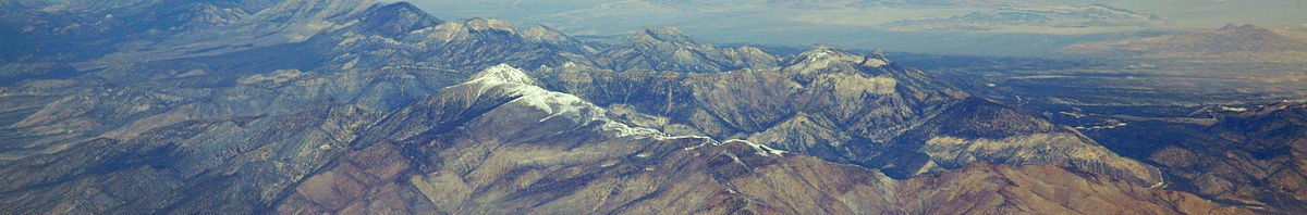
Mount Charleston stands out as the most prominent mountain in Nevada, USA. Located in its own wilderness area, this sky island is rich in wildlife and views out to the glitzy city of Las Vegas in the east and the jagged silhouettes of the Sierra Nevada Mountains in the west.
Name: Mount Charleston
Height: 3,632 m (11,918 ft)
Location: Spring Mountains, Nevada, USA
First Climbed: 1845 by JC Fremont
Climb Time: 8-12 hours
Best Time to Climb: June to October.
INTRODUCTION TO MOUNT CHARLESTON.
There are plentiful hiking and climbing opportunities, making this a mountain that will tempt everyone from the total beginner to the absolute expert to its slopes. Many visitors do come each year, often to escape the soaring heat of the desert valleys, finding relief in the forests of Mount Charleston.
Close to Red Rock Canyon, the Sisters Peaks and part of the Spring Mountains, which lead to the Californian border, Mount Charleston is a popular centrepoint for adventure, (or just a wholesome break from the casino!)
HISTORY OF MOUNT CHARLESTON.
Mount Charleston is only the common usage name for this mountain. It’s officially registered as Charleston Peak.
It was named after the town of Charleston in South Carolina, one of the US’ oldest settler towns, in 1869. This was the home of a member of the US Army Corps of Engineers who passed the mountain as part of a surveying trip to prepare the area for railroad construction.
It was also at this time that the indigenous Paiute tribe, specifically the Southern Paiute, were moved from their native lands to a reservation south of the Mount Charleston area. These would have been the indigenous population around the mountain for many centuries before this. They were probably descendants of the Paleo-Indians who first populated the Red Rock Canyon to the south-east.
In the previous decade, there had been conflict between the different Paiute tribes and the settlers. The settlers were drawn o the area by the precious metals the Nevada earth held within it. The culmination of this conflict was the Pyramid Lake War of the 1860s. This followed the decimation of the Paiute population by the Spanish in the century before, an all-too-common story told across the Americas.
In modern history, Mount Charleston was the site of a plane crash in 1955, as all hikers of the mountain will know (see the South Loop Trail below). This plane crash was shrouded in mystery for decades, part of a Cold War story, as the plane contained secrets that the US needed to keep quiet.
At the nearby Area 51, an airforce base infamous for housing unexplained goings on, a top secret spy plane was being developed. This was to be used to spy on Russia, as they supposedly developed their arsenal. The spy plane was named U-2, and those on the commuter plane that crashed were CIA officials and aircraft engineers who were working on the project.
The mystery was created when the mountain was closed of by military for a time, without any explanation as to why. It wasn’t until 1998 that the files were declassified and the world got to know just who it was that had crashed on Mount Charleston. In total, 14 people died that day, memorialised by a small monument on the peak today.
Today, as a way of supporting the mountain’s conservation, the state of Nevada issues vehicle license plates that bear the peak’s image and name. All proceeds go towards conservation grants, so if you live in Nevada and fancy a change of plates, why not give your money to a mountain (or buy one as a souvenir!)?
GEOGRAPHY OF MOUNT CHARLESTON.
With a prominence of 2,512 m (8,241 ft), Mount Charleston qualifies as an ultra-prominent peak. It is the eight most prominent in the US. It stands near the southern tip of Nevada, 35 km (22 miles) from the Californian border within the Mount Charleston Wilderness.
The mountain lies 50 km (31 miles) north-west of the truly unnatural world of Las Vegas. Its snow-capped summit is even visible to the west from certain places along the world famous Las Vegas Strip (if you can see past all the lights that is!)
As the wilderness area around Mount Charleston is often up to 17ºC cooler than the valley in which the metropolis lies, the mountain becomes a popular summer destination for sweating city dwellers.
Spring Mountains.
From its lofty vantage point, Mount Charleston gazes out over the remainder of the Spring Mountains. This range stretches along the western edge of Las Vegas to the border with California. The area in which the range sits is known as the Spring Mountains Recreation Area and resides within the Humboldt-Toiyabe National Forest.
The Spring Mountains are so named because of the many springs that lie within the range. The highest concentration of these are found on the eastern side of the mountains.
The mountains tend towards a moderately jagged appearance, particularly towards the southern end. Spring Mountains also display some of striation that is displayed more famously in the Badlands National Park.
Other notable Spring Mountains include:
• Potosi Mountain – 2,596 m (8,517 ft), also known as Double Up Mountain.
• Griffith Peak – 3,372 m (11,064 ft), south-east of Mount Charleston.
• Mummy Mountain – 3,515 m (11,533 ft), features on the North Loop Trail (see below)
• Mount Wilson – 2,155 m (7,071 ft), near the south of the range.
Sister peaks and Red Rocks.
To the north of Mount Charleston and the Spring Mountains are the Sisters. This massif consists of three peaks. The Middle Sister is the highest at 3,108 m (10,197 ft), while the North Sister is considered the most striking, but is visited less often as it is the most isolated of the three. In the saddle between the Middle and South Sister, you can find a grove of ancient Bristlecone Pines.
The Sisters are regular hiking destination, comparable to the Three Sisters which lie close to Mount Bachelor.
Between Las Vegas and the southern end of the Spring Mountains is the very popular Red Rock Canyon. This area displays fascinating geological rock formations up to 914 m (3,000 ft) high, formed over millions of years with vertical walls and coloured deep red.
Red Rock Canyon is believed to have been inhabited by Native Americans as far back as 11,000 BC (part of the first migration south through the continent).
WILDLIFE OF MOUNT CHARLESTON.
Flora.
There is extraordinary shifts of landscape as you climb this peak. From the desert floor and vertical canyon walls and cliffs nearby, to the forest of the lower slopes, the ancient forest of the ridgelines and the barren rocky summit. It is for this reason that it is classified as a sky island.
There is plentiful plant life on this mountain. Low down the slopes are open stands of ponderosa and pinyon pines, Joshua trees, mountain mahogany and white fir, among others. Fast-growing quaking aspen are found in the many avalanche chutes and gullies around the peak.
Meanwhile, ancient bristlecone pine trees are found from the canyon ridgelines to the tree-line, as the other species named find this elevation too great.
Around the tree-line, some krummholz trees form crooked nightmarish shapes amid hardy grasses and shrubs. Eventually, the mountain becomes barren rock up to the summit.
Fauna.
Animals and humans alike seem to favour Mount Charleston as a place to get away from the heat of the valley floors. This area is home to the only herd of Rocky Mountain elk in the county, as well as mountain lions, mule deers and wild donkeys called burros.
A smaller inhabitant is the white-tailed antelope squirrel, which thrives in semi-arid landscapes and has white stripes running along its sides. Other small mammals include kit foxes, Palmer’s chipmunks and golden mantle ground squirrels.
Up above and amid the trees, rock wrens, lovely blue-feathered Stella jays, mountain chickadees, white-throated nuthatches and broad-tailed hummingbirds can be spotted by a careful eye. The main aerial predator is the red-tailed hawk, which soars in search of small mammal prey, scampering around below.
FIRST ASCENT OF MOUNT CHARLESTON.
The first ascent of Mount Charleston is believed to have been achieved by one of America’s early explorers and politicians, John C Fremont.
In the mid-1800s, he led a series of expeditions across the west coast to map out its vast and unknown geography. He produced maps of the Columbia River region, was the first settler to see Lake Tahoe and camped on the militarily significant Fremont Peak, which is named after him.
It is most likely that the first ascent of Mount Charleston occurred during his expedition of 1845, when he travelled through modern-day Las Vegas, the Great Basin and the Sierra Nevada. Why he didn’t proffer a name for this peak during this time is something of a mystery.
In 1856, Fremont became the first anti-slavery presidential candidate of the Republican Party, though his campaign was marred by an incident from the recent American-Mexican war, in which he killed three unarmed men in cold blood.
CLIMBING GUIDE FOR MOUNT CHARLESTON.
There are two main routes to reach the summit of Mount Charleston (when you search for routes to also try ‘Charleston Peak’). These are: the South Loop Trail and the North Loop Trail.
South Loop Trail
The South Loop Trail is the more popular trail, in which most of the elevation is conquered in the early stages. Over half the hike takes place over 3,050 m (10,000 ft). It is 13.5 km (8.3 miles) one-way and gains 1,316 m (4,318 ft), and an early morning start is essential.
The trailhead is east of the peak. It is accessible by road at the Cathedral Rock Picnic Area, around 45 minutes from Las Vegas. Parking at the car park 400 m before this is advisable, as the picnic area is locked from the evening to the morning.
- Top long-distance hikes in North America.
- Browse a list of books about the Sierra Nevada.
- What to take on a hike.
Once on the trail, the first half is gruelling, gaining most of the hike’s elevation in the early kilometres. Heading first towards Echo Canyon, you quickly hit switchbacks that take you up to the southern ridge, passing north of Griffith Peak en route. Gaining this ridge takes around 6.5 km (4 miles) and 915 m (3,000 ft) of elevation.
After this, you can enjoy a 3 km (2 miles) section of alpine meadows that very gently ascends and will feel like a great reward for your early exertions.
Towards the tree-line, the route begins to gather steepness once more for the final summit push, marked also by the remains of the plane that crashed in 1955 (see above). Amid barren rock, the winds can really whip and the temperature can really bite. So be prepared for this shifting experience.
Return via the same route or continue onto the North Loop Trail. This hike can be completed over the course of a long day with an early start. Alternatively, make it a two-day adventure, with good camping options all along the ridgeline.
North Loop Trail
More commonly, the North Loop Trail is used as the descent of the South Loop Trail. If ascending via this route, all the elevation is gained in the second half, in contrast to the trail above. This means it is hard work at the end and lacks the views early on, though you do get views of Las Vegas.
The trailhead is north-east of the peak and the trail passes between Mummy Mountain and Fletcher Peak (3,121 m/ 10,240 ft). There trail has two options that present about halfway through, the shorter version being preferable. This is still 13.5 km (8.5 miles) and gains at least 1,347 m (4,418 ft) and is said to be “painful enough”!
The elevation gain above is an estimate, as the routes undulates much more than the South Loop Trail. The first section through forest is interrupted by switchbacks that gain a small summit. Descend into a bristlecone forest takes you towards the foot of Mummy Mountain.
Heading on towards Trail Canyon, at 6.5 km (4 miles) you’ll reach a junction with the Trail Canyon Trail. Take this (left) to avoid the extra 3 km (2-mile) North Loop Trail and head into Kyle Canyon for 3 km (2 miles). Switchbacks, some of which barely cling to the mountain like ledges, signal the last push to the summit.
If descending via this route from the South Loop Trail ascent, when you reach the end of this trail you’ll have an additional 1.6 km (1 miles) hike back to your car along tarmac roads. Think of it as your cool down.
Expert climbers only!
There is also some major, if “controversial”, rock climbing available on Mount Charleston. Most routes are rated as expert, but if hard limestone climbing, including routes in caves, is something you fancy, have a read of the climbing options on Mount Charleston.
INFORMATION ON TREKKING AROUND MOUNT CHARLESTON.
While it is often possible to hike up Mount Charleston year-round, during the winter months (November-March), there is a regular risk of avalanche. So if you decide to head up during the winter, check with local park authorities for the latest safety information and proceed with utmost caution.
Four campgrounds are dotted across the area, should you wish to take on a multi-day adventure. These are: Mahogany Grove Campground; Hilltop Campground; McWilliams Campground; and Fletcher View Campground.
It is also possible to wild camp, but ensure you register with the park authorities beforehand, especially if you intend to camp away from the campsites. No permits are required.
The surrounding area is also full of hiking options, so here’s a quick run down of some of the adventures you can choose from:
• Cathedral Rock Trail – A short 5 km (3-mile) route. Only open in the summer because of a high avalanche risk, this route includes a triumvirate of waterfalls that become a single trickle later in the season. Switchbacks greet the final summit ascent, from where you stare down the vertical walls into Kyle Canyon.
• Fletcher Canyon Trail – Another short day hike, this one includes a descent and scramble over large rocks in the streambed of the canyon. It begins with an easy ascent to the canyon ridge through the pine and mahogany forests that are typical of the Mount Charleston Wilderness.
• Other short hiking trails available in the area include: the Mary Jane Falls Trail, the Trail Canyon Trail and the Robbers Roost Loop Trail.
• One longer trail option is the Bonanza Trail. From Cold Creek, this trail swings passed Pahrump Valley, McFarland Peak (3,275 m/ 10,745 ft) and the Two Sister Peaks, as well as Bonanza Peak (3,169 m/ 10,397 ft) of course. It also passes through ancient Bristlecone forest and is a route shared by mountain bikers and horse riders, so can get pretty busy in peak summer season.