

Photo by Mark J. Miller
Name: Sierra Nevada
Highest Point: Mount Whitney, 4421m (14,505ft)
Length of range: 644km (400miles)
Maximum width: 130km (81miles)
Location: The eastern edge of California, USA.
Introduction to the Sierra Nevada.
The Sierra Nevada mountain range is full of superlatives. It contains the tallest mountain in contiguous United States, some of the country’s best known peaks, not to mention the tallest trees in the world. Views of the range from the east gives clues to its name, which translates as ‘snowy mountains’, as they appear as a barrier of bright white from valleys of brown and red rock.
Jump to Hiking and Climbing Guide in Sierra Nevada
El Capitan (2308m/ 7573ft), Half Dome (2695m/ 8842ft) and Mount Whitney (4421m/ 14,505ft) are definitely stars of this range. But there’s plenty more than impressive rock to attract visitors to these mountains. In fact, some would say the real treasure of the region lies, or perhaps lay, underground.
The Sierra Nevada was central to the gold rush in the 19th Century, when Americans sought their riches by digging down into the rock. In January 1848, gold nuggets were discovered in the American River (near Placerville). Within two years townships were being constructed to support the 50,000 working gold miners, and the serenity and wilderness were gone forever.
Gold mining, along with logging and modern tourism, have done much to change this environment. Any rapid economic development impacts the environment, but rarely so suddenly and dramatically as in this region. With the mines dug, the forests cut down and the rivers controlled, the Sierra Nevada is an example of the power of human interference with the natural world.
Yet in recent years, much has been done to conserve and protect the environment of the Sierra Nevada. This history perhaps adds to the intrigue around a range that’s easily accessed, rich in biodiversity and lists more than a few record breakers!
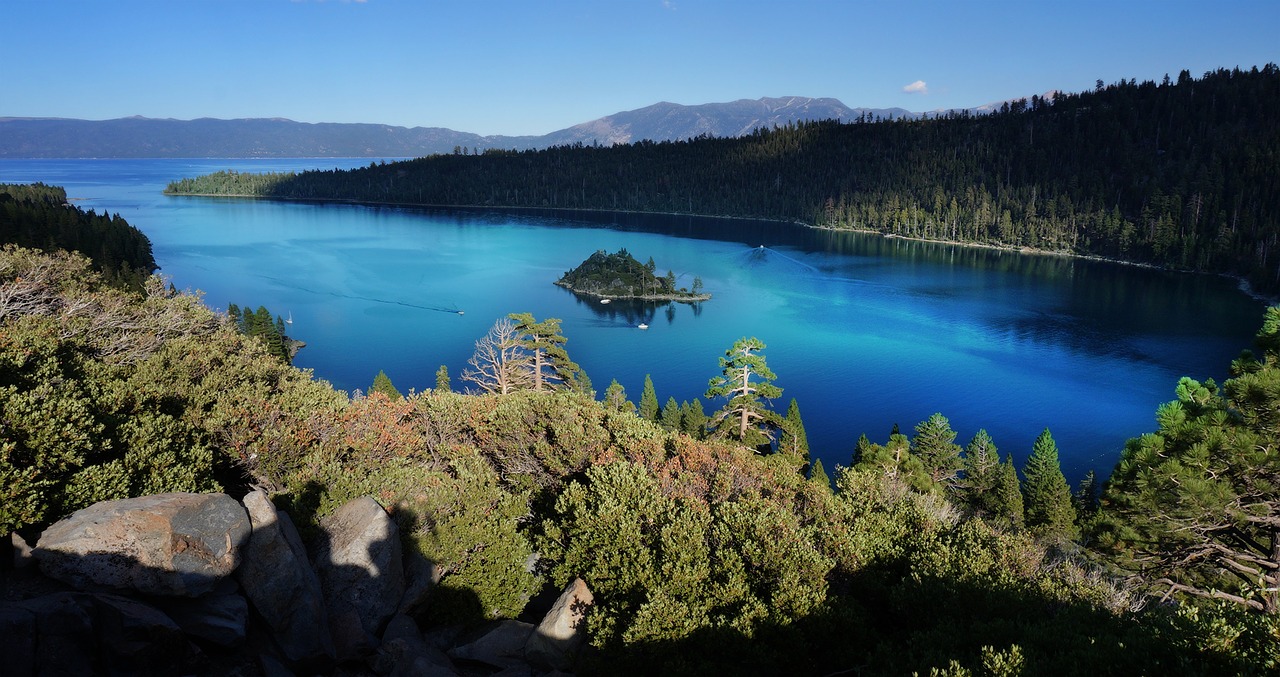
Lake Tahoe in Sierra Nevada.
Geography of the Sierra Nevada.
Located on the eastern edge of California, the Sierra Nevada range stretches 644km (400miles) north from the Mojave Desert. Up to 130km (81miles) wide, near Lake Tahoe, the Sierra Nevada Mountains are located between the expansive plains of the Great Basin to the east and the lush Sacramento and San Joaquin valleys to the west.
The mountains pass through the eastern edges of a number of national parks, including Yosemite, Sequoia and Kings Canyon. They pass through several national forests too, including the Sierra National Forest in the middle of the range and the Inyo National Forest along much of the eastern flank.
The granite that makes up most of the mountains was formed by intense volcanic activity 90 million years ago below the Earth’s crust. Towards the northern end is newer volcanic igneous rock, which is far less tough than granite.
Recent research suggests that the range itself was only formed over the last three million years, and continues to grow around one or two millimetres per year.
The process that has caused the most dramatic growth causes part of this young growth. The Sierra Nevada is an example of a ‘normal fault block’.
The eastern tectonic plate is moving away from the western plate in a process known as tectonic extension. This causes the land to the east to drop and the land to the west to rise, leading to sheer cliffs such as seen on the East Face of Mount Whitney. This also leads to the asymmetric appearance of the mountain range, with the taller peaks along the eastern side.
Although there are no glaciers in the range, once it was heavily glaciated. In fact, during the Pleistocene Epoch, which ended 11,700 years ago, over half of the range was concealed under an ice cap.
The glaciers that formed this mass of ice carved out the deep river valleys that can be seen today on either side of the range. These include Yosemite Valley, Kings Canyon, Kern Canyon and Hetch Hetchy Valley. Thousands of Alpine and subalpine glacial lakes, huge cirques and moraines (accumulations of rock debris) dotted though the range are other remnants of ancient glaciers.
The Sierra Nevada is bordered by some well-known lakes. Lake Tahoe is the largest and deepest Alpine lake in the world. It covers close to 518 sq km (200 sq miles) and plumbs depths of up to 500m (1640ft).
The majority of rivers that flow off the mountains do so to the west. Water from precipitation and snow melt makes its way down the gentle western slopes, through rivers such as the American, Yuba, Mokelumne, Stanislaus and Merced.
All lead to one of two main rivers: the Sacramento River in the north and the San Joaquin in the south. The water then feeds down to its final destination: the Pacific Ocean.
Wildlife of the Sierra Nevada.
Fauna:
The populations of larger wildlife in these mountains has decreased over the last century as the human population increased.

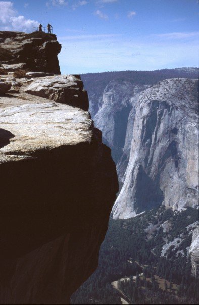
El Capitan in Yosemite National Park.
One of the animals most affected by this shift of inhabitant has been the mountain lion. Hunted first for money, then sport, since 1990 they have thankfully been protected under Proposition 117 throughout California. Today, there are around 5000 mountain lions in California, a number that continues to increase steadily.
Black bears, roaming over huge areas can be seen along the length of the Sierra Nevada. They are the most timid of all North American bears and often travel at night to avoid human contact. However, if you leave food out, you might just get a visit from one, though this is far from recommended.
Up above, the western goshawk, with its red tail, can be seen preying on other birds.
Meanwhile, the white-toed woodpecker can be seen – or heard! – at the upper reaches of the tree-line. In the timber zone, the area used for logging, the mountain chickadee, spotted owl and band-tailed pigeon have adapted to the regularly disturbed environment.
The pine grosbeak are the most southerly of their type, with most living in the northern states, Alaska and Canada. They are some of the largest winter finches and have a distinctive rose-coloured chest.
An inhabitant made famous by a Warner Bro.s cartoon is the roadrunner, found in the foothills. As its name suggests, it prefers to run rather than fly, and can reach speeds in excess of 28kph (18mph). Coyotes do eat it – so this part the cartoon was right about, but less the beep-beeping!
In the rivers, native trout species, breeding salmon and steelhead all make a good meal for the bears and other wildlife – local anglers included.
Flora:
The Sierra Nevada contains 400 endemic plant species, 200 rare species and half of California’s vascular plant life. Along the length of the range, the Sierra Nevada flora changes significantly, as well as the local variations with elevation.
Among its star inhabitants are the Sugar Pine trees – the world’s tallest pine tree. These can grow up to 61m (200ft) tall and have a seed to match! The Pinus lambertiana has a longer pinecone than any other conifer.
Yet these huge trees are dwarfed by the biggest of all – the Giant Sequoias. Growing up to 275ft tall, 36ft in diameter, the oldest of these trees is estimated to be more than 3500 years old. The biggest of the biggest is named General Sherman, and can be found in Sequoia National Park, not far from the trailhead of the High Sierra Trail.
Yet some other plants are best avoided. The Poison Oak, Poodle Dog Brush and more familiar stinging nettle all cause itchy reactions on the skin. Poison Oak is particularly nasty, with reactions to its oil often occurring long after contact and lasting up to 30 days. A good mantra for recognising, and avoiding, it is: “leaves of three, let it be”.
Other notable flora include the endemic, high-flying Sky pilot, the Snow plant, a “bloody flesh-like thing” and the medicinal Pacific Bleeding Heart plant. These can all be seen in our guide to Mount Whitney.
HIKING and Climbing in the Sierra Nevada.
Mount Whitney, at 4421m (14,505ft), is the highest mountain in the Sierra Nevada and in the entirety of the contiguous United States. It’s also one of the most frequently climbed mountains in this range.
Yet when it comes to fame, it’s two of the smaller peaks that are probably closer to the tip of the most people’s tongue: El Capitan and Half Dome.
- Find the book you need about for the Sierra Nevada; including hiking guides, climbing guides and fishing guides.
- What to take on a hike?
While significantly shorter than the four-thousanders that dominate the southern end of the Sierra Nevada, the curious curve and sheer face of Half Dome and the ultimate climbing challenge posed by El Capitan have helped to embed these Yosemite peaks at the front of public consciousness.
Following Mount Whitney, the next highest peaks in the Sierra Nevada are:
- Mount Williamson, 4382m (14,377ft),
- North Palisade, 4343m (14,249ft),
- Mount Sill, 4314m (14,154ft),
- Mount Russell, 4294m (14,088ft).
Key Trekking Routes:
The High Sierra Trail, when including the ascent of Mount Whitney, is a 105km (65mile) west to east traverse of the Sierra Nevada. It winds a route with many twist, turns and switchbacks, with regular elevation changes. Its low point is in Kern Canyon at 2073m (6801ft) and high point of 4421m (14,505ft) at Mount Whitney’s summit. Snow covers much of the trail in all but the height of summer.
The High Sierra Trail, when walked west to east begins in Crescent Meadow in the west of Sequoia National Park. Often difficult walking with steep elevations, the route passes numerous mountain glacial lakes; many route maps use these as way-markers. The Great Western Divide is crossed through the Kaweah Gap, followed by a walk up along the Kern Canyon, before turning east to aim for the top of Mount Whitney.
Allow up to seven days for this adventure. You’ll need permits, particularly for Mount Whitney, so allow time to organise these too. However, except for typical camping and hiking equipment, and a decent level of fitness to do five to seven days of hiking, you won’t need any other kit to walk this clearly marked path.
Alternatively, walk north to south, from Yosemite National Park to Mount Whitney, along the John Muir Trail. A 346km (215mile) hike that passes through Yosemite, Ansel Adams Wilderness, Sequoia and King’s Canyon National Parks and ends at the highest point of the Sierra Nevada.
This route will take anything from 24 to 30 days. You’ll camp along the way, and as with all multi-day adventures in these mountains, make sure you either carry bear-proof containers or stay at campsites with bear-proof lockers. Out there in the great American wilderness, the last thing you want is to draw a bear towards you while you’re sleeping!
There are also a number of day hikes worth exploring in the area.
Climbing up a steady incline, the route to Upper Yosemite Falls rewards you with frequent breath-taking views of the waterfall, the wooded valley below and, in the distance, Half Dome. Created over four years and completed in 1877, this well-constructed route is an 11.6km (7.2mile) return and poses only minor challenges to the fit and enthusiastic. There’s also a good chance of snow at the top as late as the end of spring.
For more of a challenge, try the ascent of Half Dome. Depending on the starting place you choose, this hike can be anything from 11-37km (7-23miles) long. The route is known for its cables, and as National Park hikes go, this certainly makes it one of the more adrenalised! Take your time on them, while well trodden, the steep climbs should never be taken too lightly.
A note to the organised: you’ll need a permit for the cables, so plan ahead a bit and try and head up at a time that avoids the crowd to prevent an irritating wait.
One guide page describes the value of the Half Dome experience succinctly:
“[It’s] the ultimate Yosemite day hike – the one you can’t die without doing, and the one you’re most likely to die while doing.”
As mentioned above, many of the mountains in the Sierra Nevada can be summitted without too much equipment or expertise. This includes the range’s high point, Mount Whitney, which is part of the High Sierra Trail.
The Armchair Mountaineer at Taft Point, Yosemite National Park
Other adventure sports.
Rock climbing:
With the sheer rock faces just asking to be climbed all along the east side of the Sierra Nevada mountains, it’ll be no surprise to find this region is perfect for those wanting to go more directly up the mountain!
Lining Yosemite Valley are some of the more famous, and populated, climbing spots including Elephant Rock, 9 o’clock wall and the Wall of Ages.
However, the pinnacle is surely El Capitan. While it offers many routes, few would be scalable without extensive prior experience. Part of the attraction of climbing El Capitan is that it marks you out as a serious climber.
If you’d rather not risk life and limb, you can ‘experience’ the climb from the comfort of your own home through Google’s latest (vertical) street map! But where’s the fun in that?
Canyoning or Canyoneering:
Heading down the mountain, through valleys and, yes, canyons anyway that you can. This adventure sport involves spending time in water, abseiling down rock face and waterfalls and hiking.
Following the line of the valley floor, the best place to do this in the Sierra Nevada is through Kings Canyon. This begins in the Sierra National Forest and continues through the National Park that carries its name.
BASE-jumping:
When you’ve gone up so directly, some may say why not go down even faster!
BASE-jumping is where the jumper leaps from the top of a vertical structure (like a sky scraper or a mountain) and quickly unfurls a parachute. Lasting a matter of seconds, this is adrenalised action at its most acute!
However there are a couple of barriers to actually leaping off a peak.
BASE-jumping requires a significant amount of training, built up first through skydiving. This training can take years. Then there is the genuine risk. BASE-jumping is simply one of the most dangerous sports you could engage in.
Finally, and most crucially here, BASE jumping is banned in all of America’s National Parks, with the threat of prison time. This hasn’t stopped those most dedicated from taking on this challenge, though this is not a choice we would condone anyone following.
Getting to the Sierra Nevada.
The main international airport near the Sierra Nevada is Sacramento, 142 km west of the range. To the east is Reno-Tahoe International Airport, situated at the northern tip of the range. Alternatively, Mammoth Yosemite Airport receives domestic connections and lands you right in the middle of the mountains.
The range has good road access though the distances between traverses, and the distance back to the roads running along the range, means planning your route carefully is pretty important. The main access roads north to south are Route 395 down the east side and Route 99 down the west side.
Smaller roads and other routes run off these main roads offering access and traverses at specified points along the Sierra Nevada. These usually related to National Park boundaries and leading to National Park controlled areas.

LATEST BLOG POSTS
I quit the rat-race to live a more adventurous life. This is my journey.