
Photo by Mr. Richard from Fair Oaks, USA.
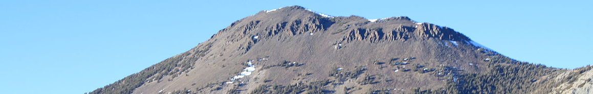
North-east of the mighty Lake Tahoe, Mount Rose (3,285 m/ 10,776 ft) rises above Washoe County on the western edge of Nevada.
Name: Mount Rose
Height: 3,285 m (10,776 ft)
Location: Part of the Carson Range in Washoe County, Nevada, USA.
First Climbed: 1 January 1895 by Dr J E Church (winter)
Climb Time: 4 to 8 hours
Best Time to Climb: May to November, possible year-round.
INTRODUCTION TO MOUNT ROSE.
From the summit of Mount Rose, panoramic views reveal the ‘vastness and sublimity’ of a surrounding landscape that includes Lake Tahoe and the long stretch of the Sierra Nevada Mountains.
A road passes close to the lower eastern edges of the mountain, and with several short walk-up hikes, this extinct volcano and its sublime views are extremely accessible. The paths are lined with wildflower meadows, making a summer hike up Mount Rose, or through its surrounding wilderness area, a real adventure treat.
Jump to Hiking and Climbing Guide
Should you need more convincing, then look no further than the eponymous poem we will quote throughout this article. Suffice it say, when John Brayshaw Kaye reached the summit of Mount Rose, he was somewhat impressed by what he discovered there:
“…What vastness and sublimity
Were spread before our eager gaze!
What wild and varied scenery!
What pictures for the poet’s lays!…”
from ‘Mount Rose’ by John Brayshaw Kaye.
HISTORY OF MOUNT ROSE.
Settler history began in the 1840s around Mount Rose, and boomed from 1859 onwards as silver ore deposits were located nearby. During this population boom, masses of timber was removed from the mountain, which was then covered by pine and scrub trees. This significant deforestation continued in earnest until the mid-20th Century, and as such very little old growth forest is found on the peak today.
There is conjecture as to the source of the mountain’s name. It was either named after an early settler, Jacob H Rose, who built a lumber mill (a little ironic given the damage he then caused the peak) or it was named after a friend of a local newspaper editor, Rose Hickman.
- Top Long Distance Hikes in North America.
- Read our guide to the Sierra Nevada.
- Find the book you need about for the Sierra Nevada; including hiking guides, climbing guides and fishing guides.
Sawmills and lumber mills were common in the area, and play an important role in Mount Rose’s history. This history is often short and dramatic, similar to many early American towns based on natural resource extraction. Many of Mount Rose’s small logging townships were destroyed by fires (apt for an extinct volcano)!
On 29 June 1905, Dr James Edward Church founded a high-altitude meteorological observatory on Mount Rose’s peak. It was one of America’s first such observatories and took advantage of the peak’s prominence to observe the weather patterns of the area.
The main focus of his work was to study snow, and it was here that he developed the modern science of snow survey. In respect of the important impact this man had on the peak, the mountain to the north of Mount Rose, 9also connected to it by a long saddle), is named after him (Church’s Peak (3,231 m/ 10,601 ft)).
Church was also the first white man to achieve a winter ascent. He climbed up on New Year's Day 1895, no doubt scouting a good spot for his observatory!
Like many mountains, Mount Rose has also featured in works of art. It seems they carry an aspiration quality, in which the American ideals are made manifest by such landscapes. One example if the poem ‘Mount Rose’ by John Brayshaw Kaye, sections of which are featured throughout this article.
GEOGRAPHY OF MOUNT ROSE.
Mount Rose is the highest Nevada mountain within the Sierra Nevada Range (the majority of which is found in California) and stands to the west some of the fastest expanding population centres in the state (Reno, Carson City and Truckee Meadows). The mountain is made accessible to these populations via the Nevada State Route 431, which traverses to the south-east of the peak’s summit.
Carson Range.
Mount Rose is the second highest peak in the Carson Range. This range is a spur of the Sierra Nevada, and is separated from the main range by the Lake Tahoe Basin.
The Carson Range runs for 80 km (50 miles) from along the eastern side of Lake Tahoe. Freel Peak is the high point, standing a little taller than Mount Rose at 3,318 m (10,886 ft). They are found at opposite ends of the Carson Range, with Freel Peak south-east of Lake Tahoe close to where it joins the main Sierra Nevada Range.
Mount Rose is one of the more prominent peaks in the area, with 1,106 m (3,630 ft) of clear slope between it and the next lofty mountain. It marks an eastern edge of the mountain range, draining predominantly towards the Washoe Valley in the east. Snow covers its summit from November/December until April, giving a shorter snow-capped season than other Sierra Nevada peaks to the west.
The mountain is a mixture of granite and metamorphic rock, indicating its largely volcanic formation.
Mountain Formation.
Mount Rose was formed within the past 30 million years through volcanic action. This makes it young in comparison with some sections of the Sierra Nevada Range, which are thought to have begun forming over 250 million years ago. Though this volcano is extinct, hydrothermal activity is still found less than 16 km (10 miles) east of the summit.
Mount Rose, and the Carson Range more generally, is the marking point of the transition zone that separates the Sierra Nevada in the west from the Great Basin in the east.
This whole area was lightly glaciated in the distant past. This has led to peaks of volcanic origin having a sharper appearance and deeper valleys than a volcanic formation would create alone. The proximity of lakes such as Tahoe and Washoe are also relics of the glaciation, though many other lakes have dried sufficiently to have become alpine meadows.
Mount Rose Wilderness.
The Mount Rose Wilderness is part of the Humboldt-Toiyabe National Forest. The wilderness area covers 31,320 acres and was designated by the US government in 1989. It lies entirely within the state of Nevada, meaning that Mount Rose is found towards its south-western edge.
As the area receives less rainfall (around half), and a shorter snow season, than the western edge of Lake Tahoe, this alpine wilderness is considered one of the more accessible options for visitors throughout the year. It is mainly accessed by the Hunter Lake jeep road, which splits the area unevenly in two (north and south) and its border nudges up to the edge of the city of Reno.
The wilderness area consists largely of the highlands of the Carson Range. While it is one of the most widely used wilderness areas in the USA, it still manages to retain some secrets and solitude. Within its interior are a few lakes and meadows that are rarely visited and are real prizes for those visiting in search of genuine wilderness.
WILDLIFE OF MOUNT ROSE.
Flora.
One of the best places to see the diverse wildflower population on Mount Rose is the Mount Rose Meadows Wildflower Viewing Area. It is located just off the New Mount Rose Summit Trail (see below) close to the waterfall. It stretches some way towards the summit from here, meaning you can enjoy a colourful hike if you go in the right season.
Here, you can see eclectic inhabitants such as the blue large-leaved lupine, the bright yellow bigelow sneezeweed or the white cones of the alpine gentian. These are best seen during the peak visiting season, mid-June to mid-August.
Being an ecological transition zone, the flora found around Mount Rose contains plants and trees found in both the Sierra Nevada to the west and the Great Basin to the east. This is significant because these landscapes are very different: thick pine, fir and hemlock forests, glacial lakes to the west; a semi-arid landscape in which sagebrush and pinion pine are the main inhabitants.
Fauna.
As with the flora, so the fauna. The animals and birds found here are comparable to those found across this whole area, including large mammals such as deer, black bears and mountain lions.
Some of the smaller animals include the American marten, the common raccoon, the snowshoe hare and the mountain beaver. But perhaps the pick of the small mammals found on the mountain is the striped skunk. So visit Mount Rose and you really could meet Pepe Le Pew!
The bird life on the mountain varies from small songbirds (orange-crowned warbler, townsend’s solitaire and the pygmy nuthatch) to birds of prey (northern goshawk, bald eagle and the turkey vulture).
FIRST ASCENT OF MOUNT ROSE.
There is no clear evidence of when the first ascent of Mount Rose occurred. Given the accessibility of this peak, and the long periods that it is without snow each year, we can only surmise that it was a peak that was summitted relatively early on by white settlers, and no doubt by the indigenous Native American population before them.
However, we do know that the first winter ascent was made by Dr James Edward Church on 1 January 1895. A university professor, he was also responsible for opening the first observatory on Mount Rose, which continues to make the mountain a valuable resource for the area (see History of Mount Rose, above).
CLIMBING & HIKING GUIDE FOR MOUNT ROSE.
“We reached the top – I scarce know how
And stood upon the mountain’s brow.
Our weary limbs and wasted strength
Are straightaway all forgotten now…”
from ‘Mount Rose’ by John Brayshaw Kaye.
Perhaps the poet Kaye was marvelling at the views down to the south-west, gazing across a zig-zagging ridgeline that guides the eye to the shimmering expanse of Lake Tahoe.
Or perhaps he was looking north to Lassen Peak (3,189 m/ 10,463 ft), a volcano whose last eruption lasted from 1914-1917. With panoramic views in all directions, reaching the summit via any of the four Mount Rose routes listed here promises to be an energising, breathtaking experience.
The New Mount Rose Summit Trail
The most popular summit hike is a fine day’s adventure at 16 km (10 miles) return. It gets very busy in the summer, particularly on weekends. For more solitude head up on a weekday (or choose one of the other trails).
- Top Long Distance Hikes in North America.
- Find the book you need about for the Sierra Nevada; including hiking guides, climbing guides and fishing guides.
- What to take on a hike.
The New Mount Rose Summit Trail is a well-marked and maintained path. It begins from the mountain’s main trailhead: a car park on the Nevada State Route 431 named (somewhat prematurely) ‘Mount Rose Summit’. Good information is provided here, though the stream of people and the stairs that mark its start make this a little obsolete most of the time.
The first half of the ascent is relatively level, walking passed the north of Tamarack Peak (3,017 m/ 9,897 ft). After the waterfall that is one of the route’s highlights, the majority of the hike’s elevation gain (around 518 m/ 1,700 ft) begins with great enthusiasm.
The first section sees you gain the saddle to the north-west of Mount Rose (joining it with Church’s Peak) then a second shorter but no less steep ascent carries you up to the summit.
You can also stop on this route (many do) after about 4 km (2.5 miles) when you come to the impressive waterfall that marks the start of the steep ascent. This makes for a lovely, unchallenging walk through open Nevada scenery, should avoiding “weary limbs and wasted strength” by a favoured option.
The Old Mount Rose Trail
The second route is arguably rightly less popular than its new counterpart. While it takes in a few of the ponds and open forest found to the south of the newer trail, it involves hiking along roads for the majority of the route until it joins the new trail higher up the mountain. For hiking purists, a road is a real deterrent.
However, it is a longer hike (19 km/ 12 miles), requires a little more elevation gain, and is perhaps a little quieter in the sections that are away from the new trail. For these reasons it may be favoured by some hikers.
South-east Ridge Route.
The shortest ascent begins in a dirt car park near Galena Creek, found several kilometres short of the trailhead previously mentioned. At this north-western edge of the state road, there is only 4.5 km (2.8 miles) to the summit, which will be almost directly due west of you.
The South-east Ridge Route is a steady climb from this trailhead to the summit, though the final climb has a definitive kick in it.
The trail begins by crossing a bridge over the creek, then heads along the trail to reach Point 10,005, an eastern shoulder of Mount Rose. This is where the official trail ends, and it is then a case of picking the most direct route up the ridge from here.
Spring and autumn are recommended for this route, as the summer has a higher possibility of unwelcome wildlife slithering across your path.
White Creek Loop Trail.
The closest route to Reno is the White Creek Loop Trail. It is the steepest of all the routes listed, gaining around 1,433 m (4,700 ft) over 8 km (5 miles). From the trailhead at the entrance of Galena Creek County Park, head up the Jones Creek Trail for 4.3 km (2.7 miles) until you reach Church’s Pond (2,527 m / 8,290 ft).
From here, cross to the right of the wooded hillside to meet a boulder field which presents views of the summit destination in the south-west. This boulder field leads you all the way to the summit. From Church’s Pond to the summit is around 3.2 km (2 miles) and gains nearly 792 m (2,600 ft).
INFORMATION ON TREKKING AROUND MOUNT ROSE.
Mount Rose Ski Tahoe is actually located on nearby Slide Mountain (2,956 m/ 6,417 ft) across the Nevada State Route 431. Their slogan promises much: “Treat Yourself to Really Good Snow”. Between December and late March each year it offers just this, weaving exciting runs down tree-lined slopes.
The nearby Tahoe Rim Trail is one of America’s great walks. Accessible for hikers, mountain bikers and horse riders alike, the many trailheads provide a variety of choices for enjoying a day hike or thru-hike around this stunning lake (and the numerous alpine lakes that surround it).
Closer still is the Mount Rose Wilderness, which stretches to the north of the summit. This is a special area for hikers and nature lovers alike, with a varied landscape and a large number of adventure options.
All trailheads within the Mount Rose Wilderness are within 10 to 45 minutes of downtown Reno and new trail developments are underway to add around 32 km (20 miles) of extra tracks.
Other peaks that lie within the wilderness area include Mount Houghton (3,197 m/ 10,490 ft), Tamarack Peak, Relay Peak (3,150 m/ 10,335 ft) and Snowflower Mountain (3,122 m/ 10,243 ft). But this network also offers non-summit routes that include beautiful walks that pass through wildflower meadows.